

Photo: elminium, Wikimedia Commons (CC BY 2.0) — Mt. Buko from the north, with the terraced quarry face above the fields of Chichibu (May 2014)

Mt. Buko Hiking Guide: Chichibu's Quarry-Cut Peak from Yokoze, the 52-Chōme Trail, Taxi and Laview Access, and Late-Autumn Cautions (2026)
An English guide to Mt. Buko (武甲山, 1,304 m), the limestone mountain that towers over the Chichibu basin in Saitama. Covers the Laview limited express from Ikebukuro to Yokoze, the taxi or two-hour walk to the Ichi-no-torii trailhead, parking, the Omotesando trail marked by 52 chōme stones, the loop down via Shirajikubo, the closed Hashidate course, the summit toilet's winter closure, bears, phone signal, and how short November days change your plan.
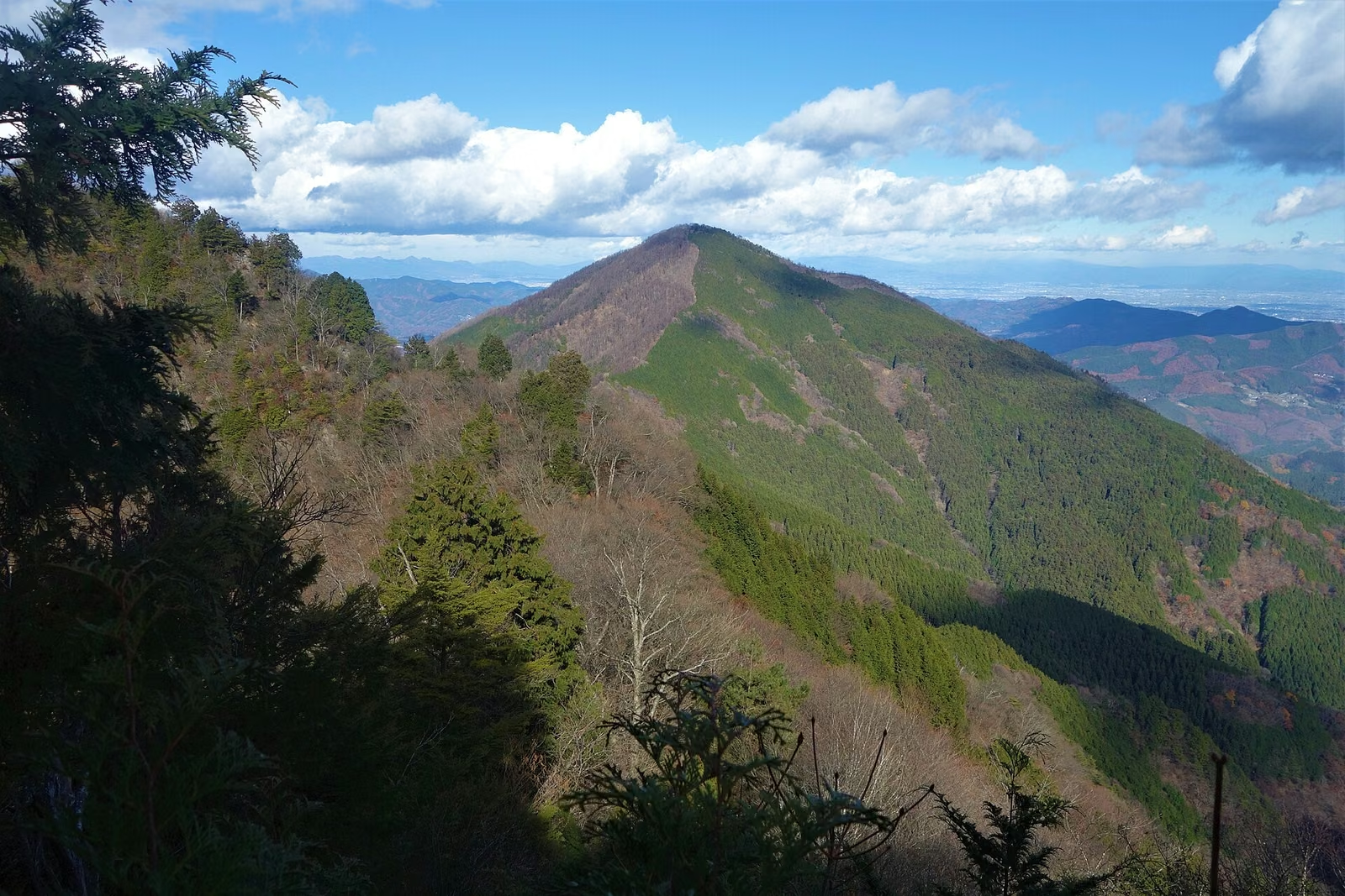
If you have ever ridden the Seibu Line into Chichibu, you have seen Mt. Buko (武甲山, Bukō-san). It fills the window as the train nears Yokoze: a big, dark, triangular mountain whose north face has been cut into grey terraces by limestone quarrying. It is the symbol of the Chichibu basin and one of the 200 Famous Japanese Mountains (Nihon Nihyaku-meizan).
The quarry face makes it look harsh from town, but the hiking trail climbs the forested eastern side and stays well away from the quarry until you look down on it from the summit. You walk up through tall cedar and mixed broadleaf forest, past a small waterfall shrine and a giant cedar, to a summit shrine with an observation deck that looks straight down on Chichibu. It is a proper mountain day, not a stroll, but it needs no special skills and can be done as a day trip from Tokyo by train.
This guide is written for travellers and residents who do not read Japanese signs easily. It covers the train and taxi, the trail, the times, the facilities, what is closed, and what changes in late autumn, when the days are short and the summit toilet shuts for winter.
Mt. Buko at a Glance
| Item | Details |
|---|---|
| Elevation | 1,304 m at the summit (the triangulation point is 1,295 m) |
| Location | Yokoze Town and Chichibu City, Saitama Prefecture |
| Nearest station | Yokoze (Seibu Chichibu Line) |
| Main trailhead | Ichi-no-torii (一の鳥居, "first shrine gate"), on the Ubukawa side, about 518 m |
| Standard route | Omotesando (Ubukawa) trail up; down the same way, or loop via Shirajikubo |
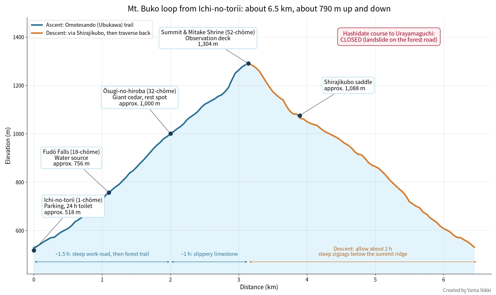
| Loop distance / climb | About 6.5 km, about 790 m up and down |
| Walking time | About 2.5 h up, about 2 h down, plus breaks |
| Water on the trail | Fudō Falls at the 18th chōme marker (treat as a backup, not your main supply) |
| Toilets | Ichi-no-torii (open 24 hours); summit (rainwater type, closed in winter) |
| Closed route | Hashidate course down to Urayamaguchi Station (landslide on the forest road) |
| Tourist information | Yokoze Town "Bukō-san" Tourist Information Office, tel. 0494-25-0450 |
The name has an old legend attached. Seibu Railway's hiking page retells it: Prince Yamato Takeru was so moved by the mountain's shape that he laid his armour (kabuto) here, and the mountain became "Bukō", the armour mountain. Quarrying has since changed its outline, but it is still the mountain everyone in Chichibu looks up to.
Why Go in Late Autumn, and What Changes
Late October to mid-November is one of the best times on Mt. Buko. The broadleaf trees above the cedar plantations turn yellow and red, the air is clear, and from the summit you can see across the basin to the mountains of western Gunma. Our 15 autumn-leaves day hikes from Tokyo puts Mt. Buko in the late-October to mid-November window.


Three things make a November visit different from a summer one:
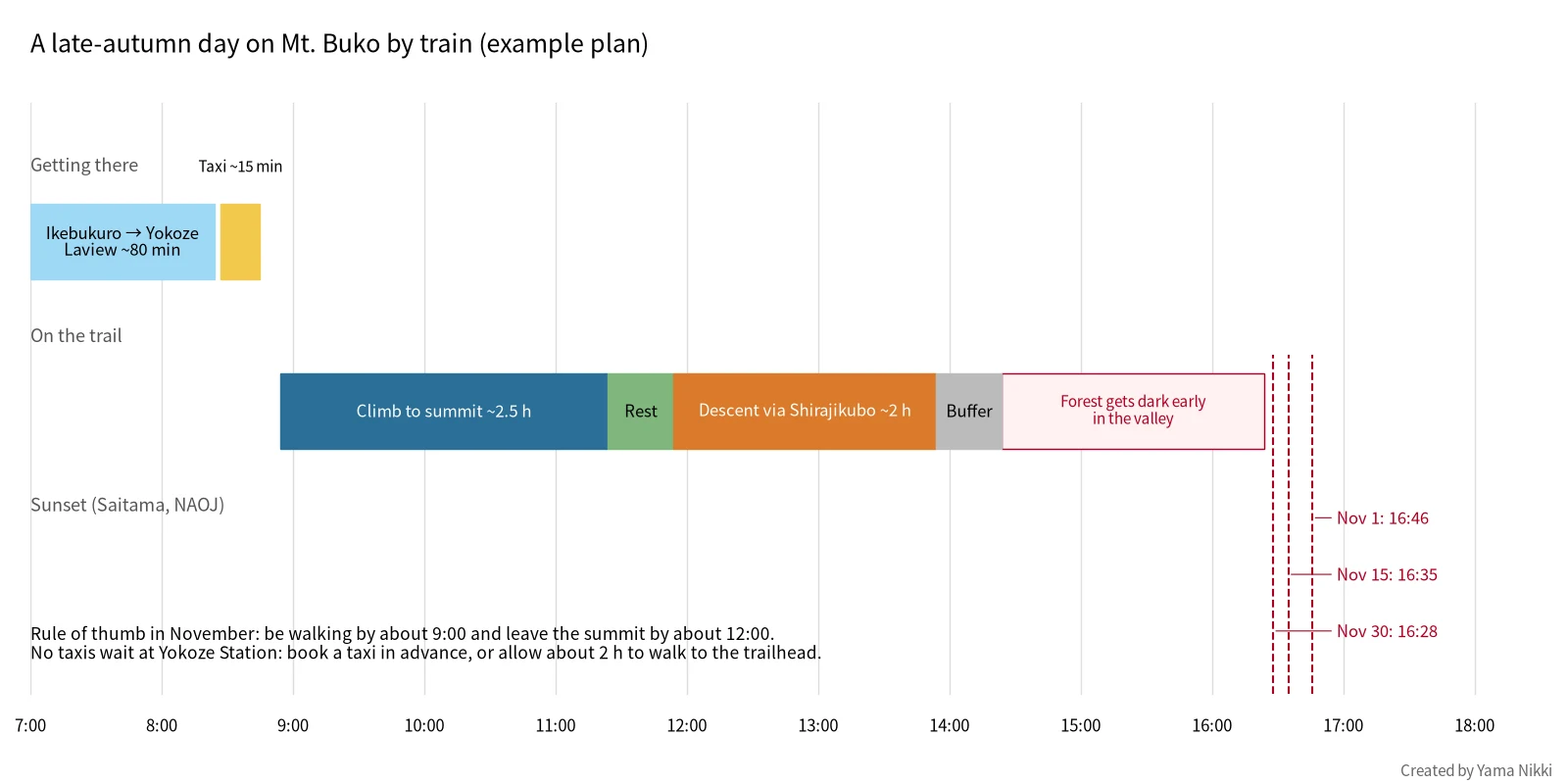
- Short days. According to the National Astronomical Observatory of Japan (NAOJ), sunset in Saitama is at 16:46 on November 1, 16:35 on November 15 and 16:28 on November 30. The trail is in deep cedar forest on the east side of the mountain, so it gets dark under the trees well before the official sunset.
- The summit toilet closes for winter. It runs on rainwater and is shut to stop the pipes freezing. Last year Yokoze Town closed it from November 28 and reopened it on April 30. Yokoze Town announces each year's closing date on its Mt. Buko page, so check it before a late-November hike and carry a portable toilet bag either way.
- Hunting season. In most of Honshu the general hunting season starts on November 15. Wear something bright, stay on the main trail, and see our hunting-season guide for what to look out for.
For a wider look at what shuts down across Japan's mountains at this time of year, see Late-Autumn Mountain Facility Closures.
Getting There by Train: Laview to Yokoze
Mt. Buko is one of the easiest 1,300 m peaks to reach from central Tokyo without a car. The nearest station is Yokoze, one stop before Seibu-Chichibu.
Seibu Laview limited express
The fastest option is Seibu's Laview limited express "Chichibu" from Ikebukuro. It stops at Ikebukuro, Tokorozawa, Irumashi, Hannō, Yokoze and Seibu-Chichibu, so you do not need to change trains. Ikebukuro to Yokoze takes roughly 75–80 minutes.
| Item | Ikebukuro → Yokoze |
|---|---|
| Limited express charge (Laview) | ¥900 adult, ¥450 child |
| If you board without a limited express ticket | ¥200 extra (on-board purchase) |
| Regular fare | ¥790 ticket / ¥781 IC card (Suica, PASMO), after Seibu's March 2026 fare revision |
| Total with Laview | About ¥1,690 one way |
| Ticket sales | From 7:00, one month before travel; ticketless booking with Seibu's "Smooz" service |
All Laview seats are reserved. On autumn weekends the morning trains to Chichibu are popular, so book in advance if you can. You can also take ordinary trains for the regular fare alone; you will usually change at Hannō, and the trip takes about 1 hour 45 minutes.
Sources: Laview limited express (Seibu Railway), Seibu fare search (Seibu Railway)
From Yokoze Station to the trailhead
The trail starts at Ichi-no-torii, the first shrine gate on the Ubukawa side of the mountain. It is about 6 km from Yokoze Station, past the cement works and up the Ubukawa valley road.
- On foot: about 2 hours each way, according to Yokoze Town and the Bukō-zan Museum. That turns a 4.5-hour hike into an 8.5-hour day, which does not fit well with November daylight.
- By taxi: about 15 minutes. No taxis wait at Yokoze Station, so you must book. Yokoze Town's tourist site lists Chichibu Hire (秩父ハイヤー, free dial 0120-118-184). The fare to Ichi-no-torii is roughly ¥2,300. If you board at the "Chichibu Hire" taxi stand in front of Yokoze Station there is no pick-up charge; if the taxi has to come and get you, add about ¥500.
For the return, phone signal at Ichi-no-torii can be weak (see below), so it is safest to agree a pick-up time with the taxi company in the morning, or call from higher up the trail where you have signal.
Sources: Mt. Buko information (Yokoze Town Tourism), Chichibu Hire (Yokoze Town Tourism), Mt. Buko hiking course (Bukō-zan Museum)
By car
If you drive, there are two places to park near the trailhead:
| Parking | Capacity | Notes |
|---|---|---|
| Ichi-no-torii parking | About 30 cars | Next to the trailhead; flush toilet open 24 hours |
| Mt. Buko hikers' parking (武甲山登山駐車場) | About 50 cars | Free; on the Ubukawa riverbed about 200 m before Ichi-no-torii; opened in April 2024; unpaved, and cannot be used in heavy rain |
Large buses cannot get up the road. In winter the road can be icy; Yokoze Town has warned against driving it on normal tyres. Ichi-no-torii fills early on fine weekends in autumn.
Source: Mt. Buko hikers' parking (Yokoze Town)
The Route: Omotesando Trail and the Shirajikubo Loop
There are several ways up Mt. Buko, but for a first visit there is one clear choice: climb the Omotesando (表参道, "main approach") trail from Ichi-no-torii. It is the historic pilgrims' path to the summit shrine, it is the best marked, and it is the route Yokoze Town and Seibu Railway present as the standard course.
You can go back down the same way, or make a loop by heading south along the ridge to the Shirajikubo saddle and traversing back to the Omotesando lower down. The loop adds variety and only a little time.
What the chōme stones mean
The Omotesando is measured in chōme (丁目), an old Japanese unit of distance used on pilgrim paths. Ichi-no-torii is the 1st chōme and the summit shrine is the 52nd. Small stone markers with the number carved on them stand beside the trail all the way up. They are the easiest way to judge your progress: if you reach the 32nd marker at Ōsugi-no-hiroba, you have done most of the distance but still have the steepest, rockiest part ahead.


Section 1: Ichi-no-torii to Ōsugi-no-hiroba (about 1.5 hours)
From the gate, the first part follows a steep paved work road for about 30 minutes to around the 15th chōme. It is not pretty, but it gains height fast. The real trail then enters the cedar forest.
At the 18th chōme you reach Fudō Falls (不動滝), a small waterfall with a tiny shrine. This is the only water source on the route. You will probably see plastic bottles left here: they are for a local custom. The summit toilet runs on collected rainwater, and Yokoze Town asks hikers who can manage it to fill a bottle here and pour it into the tank at the summit. It is entirely voluntary, but it helps keep the toilet open.
Above the falls the path climbs steadily in zigzags through the cedars. About an hour from the 15th chōme you reach Ōsugi-no-hiroba (大杉の広場, "Big Cedar Square") at the 32nd chōme, around 1,000 m. A huge old cedar stands here, and it is the natural place for a break.


Section 2: Ōsugi-no-hiroba to the summit (about 1 hour)
Above the big cedar the character of the trail changes. There is more limestone underfoot, and the Bukō-zan Museum specifically warns that it is slippery. Wet limestone, and limestone covered with fallen leaves in November, can be as slick as ice, especially on the way down. Take short steps and keep your weight over your feet.
The mixed broadleaf forest begins to replace the cedars here, which is where most of the autumn colour is. The trail reaches Mitake Shrine (御嶽神社) at the 52nd chōme. The observation deck is just behind the shrine, and the summit toilet is nearby.
In June 2026 Yokoze Town also warned that a broken branch near the summit was in danger of falling. Look up as well as down around the summit area, and do not linger under damaged trees on windy days.
At the summit
The view from the deck is the reason to come. You look straight down over the quarry terraces to the towns of Yokoze and Chichibu, with the mountains of Okuchichibu and western Gunma behind. Seibu Railway mentions Ryōkami-san and Jōmine-san among the peaks you can see. In spring the pink moss phlox of Hitsujiyama Park shows up in the town below. A fence keeps you away from the quarry edge; stay behind it.


On May 1 every year, a mountain-opening ceremony is held at Mitake Shrine and the summit gets busy. In late autumn it is usually quieter, but the deck is small, so on a fine November weekend you may have to wait your turn for photos.
Section 3: The loop down via Shirajikubo (about 2 hours)
Going back down the Omotesando is the simplest choice and is fine for a first visit. If you want the loop, follow the signs south from the summit toward Shirajikubo (シラジクボ). The trail drops off the summit ridge in steep zigzags with loose stones and roots. This is the part of the day where most slips happen, so go slowly.
Shirajikubo is a saddle at about 1,088 m between Mt. Buko and Mt. Komochi. From here, turn left (east) and follow the trail that traverses back across the slope and down to the Omotesando and Ichi-no-torii. Straight on along the ridge leads to Mt. Komochi and Mt. Ōmochi, which is a much longer and rockier day.


Do not plan to descend to Urayamaguchi
Older guidebooks and the Bukō-zan Museum's own course description show a route down the far side of the mountain via the Hashidate course to Hashidate Cave and Urayamaguchi Station on the Chichibu Railway. That route is closed. Chichibu City reported in February 2026 that the Hashidate course remains closed because of a landslide on the forest road, and Seibu Railway's hiking page also says you cannot descend to Urayamaguchi. Until the city announces a reopening, plan to come back down to Ichi-no-torii.
Sources: Hashidate course closure (Chichibu City tourism blog), Mt. Buko course (Seibu Railway hiking guide)
Longer option: the Ōmochi and Komochi ridge
Experienced hikers sometimes link Mt. Buko with Mt. Komochi (小持山, 1,273 m) and Mt. Ōmochi (大持山, 1,294 m) to the south, returning by the Tsumasaka Pass trail. It is a fine ridge, but it has rocky sections and a much longer walking time, and in August 2026 Yokoze Town reported a bear-like animal seen near Mt. Ōmochi. Leave it for a long day in spring or early autumn, after you know the area.

Times and Difficulty
| Section | Time (guide) |
|---|---|
| Ichi-no-torii → 15th chōme (work road) | About 30 min |
| 15th chōme → Fudō Falls (18th) → Ōsugi-no-hiroba (32nd) | About 1 h |
| Ōsugi-no-hiroba → summit (52nd) | About 1 h |
| Summit → Shirajikubo → Ichi-no-torii | About 2 h |
| Total walking (loop) | About 4.5 h, plus breaks |
The ascent times come from the Bukō-zan Museum's course guide. The descent time is a typical planning figure for the Shirajikubo loop. If you are not used to Japanese mountain trails, add 30–60 minutes to all of these.
In terms of effort, this is a solid half-day climb: nearly 800 m of height gain with little flat ground. There are no chains or ladders on the Omotesando, but the upper section is rocky and the descent is steep. If you can comfortably do the Mt. Takao Inariyama trail and want a step up, Mt. Buko is a good next mountain. It is a harder day than Mt. Mitake or Mt. Tsukuba, where cable cars do much of the climbing for you.
Facilities: Water, Toilets and Phone Signal
| Facility | Where | Notes |
|---|---|---|
| Toilet | Ichi-no-torii | Flush toilet, open 24 hours |
| Toilet | Summit | Rainwater type; after one use it takes 5–8 minutes for the tank to refill, so it cannot be used continuously. Closed in winter (last year from November 28) |
| Water | Fudō Falls (18th chōme) | Natural water; treat or boil before drinking, and carry your full day's supply from home |
| Shops | None on the trail | Buy food and drinks before Yokoze Station; there is nothing at Ichi-no-torii |
| Phone signal | Ichi-no-torii | In July 2026 Yokoze Town reported weak docomo signal at Ichi-no-torii; au works there, according to an earlier town notice |
Because the summit toilet depends on rain, it can also be closed when the tank runs dry. Plan to use the toilet at Ichi-no-torii before you start, and carry a portable toilet bag.
Source: Mt. Buko information (Yokoze Town Tourism)
Safety: Trail Markings, Bears and Planning
Do not follow pink ribbons blindly
In August 2026, Yokoze Town put out a warning that the pink ribbons tied to trees on Mt. Buko do not always mark the hiking trail. Some are left by forestry workers or surveyors. Follow the official signposts and the chōme stones, and check your position on a map app with the trail downloaded for offline use.
Bears
Asian black bears live in the Chichibu mountains. Yokoze Town has posted several sightings over the years, including one near the Enmeisui spring on the Ubukawa side in November 2022 and a bear-like animal near Mt. Ōmochi in August 2026. Bears are still active in November as they feed before winter. Carry a bell or talk as you walk, and see our guide to bear safety in Japan for what to do if you meet one.
What the town asks of hikers
Yokoze Town's safety notes ask hikers to plan within their fitness and experience, avoid hiking alone where possible, submit a climbing plan (tozan todoke) and tell family where they are going, carry something that makes noise for bears, and keep their phone's GPS switched on before entering the mountain. If you are new to these customs, our Japan hiking rules and basics explains them in English.
Emergencies
In an emergency, call 110 (police) or 119 (fire and ambulance). Tell them you are on Mt. Buko (Bukō-san) in Yokoze Town, Saitama, and give the nearest chōme number if you can see a marker. Those numbers make it much easier for rescuers to find you.
What to Bring in Late Autumn
- Proper hiking shoes with good grip, for wet limestone and leaf-covered slopes.
- Warm layers. On a calm November morning it can be comfortable at Yokoze but close to freezing at the summit, with wind on the deck. Bring a fleece or light insulated jacket and a windproof shell. Our layering guide has more detail.
- Gloves and a hat, especially from mid-November. See late-autumn hiking gloves.
- A headlamp, even if you plan to be down by 14:30. The cedar forest gets dark early.
- Water and food for the whole day: at least 1 litre of water, more in warm weather, plus snacks. There are no shops after Yokoze Station.
- A portable toilet bag, especially from late November when the summit toilet is closed.
- A bear bell and bright clothing for hunting season.
- Trekking poles are useful on the descent.
- Light chain spikes if you go after a cold snap in late November or December. Ice can form on the north- and east-facing parts of the trail; see frozen trails in late autumn.
- Cash for the taxi, in case card payment is not possible.
Sample Day Plan
- Early morning — An early Laview from Ikebukuro (book a seat in advance), arriving at Yokoze before 9:00. Check the current timetable on Seibu Railway's site.
- About 8:50 — Pre-booked taxi from the taxi stand in front of Yokoze Station to Ichi-no-torii. Toilet stop.
- About 9:00 — Start walking up the work road.
- About 10:30 — Fudō Falls and Ōsugi-no-hiroba; a short break.
- About 11:30 — Summit, Mitake Shrine and the observation deck. Lunch.
- By 12:00 — Leave the summit. Down via Shirajikubo, or the same way you came up.
- About 14:00 — Back at Ichi-no-torii. Taxi to Yokoze Station.
- Afternoon — Ride one stop on to Seibu-Chichibu for food and a hot bath at the station's hot-spring complex, or go straight back to Tokyo.
If you are slower than the guide times, the rule of thumb is simple: turn around at the time you set in the morning, wherever you are. In November, the summit at 12:00 leaves time for a slow descent and a delay or two before dark.
After the Hike
The Bukō-zan Museum (武甲山資料館) stands in Hitsujiyama Park in Chichibu City, a walk from Seibu-Chichibu Station. It is a small museum devoted to the mountain, and it also publishes a hiking course guide. On the way back, Seibu-Chichibu Station, one stop beyond Yokoze, has Matsuri no Yu, a day-use hot spring with Chichibu food and souvenirs right outside the station, which makes it easy to wash off the mountain before the train home.
Frequently Asked Questions
Can I climb Mt. Buko without a taxi?
Yes. Walk from Yokoze Station, about 6 km and 2 hours each way along the Ubukawa valley road. In November that makes a very long day, so start early and carry a headlamp.
Is Mt. Buko suitable for beginners?
It suits beginners who already have some fitness and have done a few shorter hikes. It is not technical, but it is a continuous 790 m climb with a slippery upper section. First-time hikers will be happier on Mt. Takao or Mt. Mitake first.
Can I see the quarry from the trail?
Not really. The trail is on the forested side of the mountain. You see the quarry from below (from the train and from town) and from the summit observation deck, which looks down on it.
Can I go down to Urayamaguchi Station?
Not at present. The Hashidate course to Urayamaguchi is closed because of a landslide on the forest road. Return to Ichi-no-torii.
Is the summit toilet open in November?
Usually until late November. Last year it closed on November 28 for winter. Check Yokoze Town's Mt. Buko page and carry a portable toilet bag in any case.
References
- Mt. Buko information and notices (Yokoze Town Tourism, in Japanese)
- Chichibu Hire taxi (Yokoze Town Tourism, in Japanese)
- Mt. Buko hikers' parking (Yokoze Town, in Japanese)
- Mt. Buko hiking course (Bukō-zan Museum, in Japanese)
- Mt. Buko course (Seibu Railway hiking guide, in Japanese)
- Laview limited express (Seibu Railway, in Japanese)
- Seibu fare search (Seibu Railway, in Japanese)
- Hashidate course closure (Chichibu City tourism blog, in Japanese)
- Sunrise and sunset, Saitama, November 2026 (National Astronomical Observatory of Japan, in Japanese)
- Matsuri no Yu, Seibu-Chichibu Station (Seibu Leisure, in Japanese)