

Photo: Mzaki, Wikimedia Commons (CC0). Mount Oyama and its south ridge seen from the fields of Kamiya, Isehara, April 8, 2026.

Mount Oyama Day Trip from Tokyo: Cable Car, Afuri Shrine, the Summit Loop, Freepass Math, and Late-Autumn Tips
A practical English guide to Mount Oyama (大山, 1,252 m) in Isehara, Kanagawa, organized by how much you want to climb. Covers the Odakyu Line from Shinjuku, the Kanachu bus to Oyama Cable, Oyama Cable Car fares and hours, Afuri Shrine Shimosha and Oyama-dera Temple, the classic summit loop with its chain sections, the quieter start from Yabitsu Pass, whether the Tanzawa-Oyama Freepass pays off, bears, autumn leaves, and an onsen stop at Tsurumaki.
This guide is built on the official pages of the Oyama Cable Car (Oyama Kanko Dentetsu), the Tanzawa-Oyama Area Navi course pages, Odakyu’s Tanzawa-Oyama Freepass page, the Kanagawa Prefectural Police, Kanagawa Prefecture’s bear information, and Hadano City. Fares and timetables change; open the linked pages on the morning you travel.
Mount Oyama (大山, Ōyama) is a pyramid-shaped peak that the cable car operator calls a landmark seen from across the Sagami Plain and even from the sea. The operator describes it as a 1,252 m mountain in the Tanzawa-Oyama Quasi-National Park, about two hours from central Tokyo, with Isehara City as its front door. Its other name, Afuri-yama (雨降山, “rain-falling mountain”), comes from the moist winds off Sagami Bay that bring rain to the peak. In the Edo period, pilgrimages here (Ōyama mairi, 大山詣り) were so popular that, according to the operator, around 200,000 people are said to have climbed in a single summer when the summit was open. The area was recognized as a Japan Heritage site in 2016.
What makes Oyama a good day trip is that it works at three very different effort levels — from a 6-minute cable car ride to a shrine with a famous view, all the way to a full ridge hike. This guide is organized around that choice.
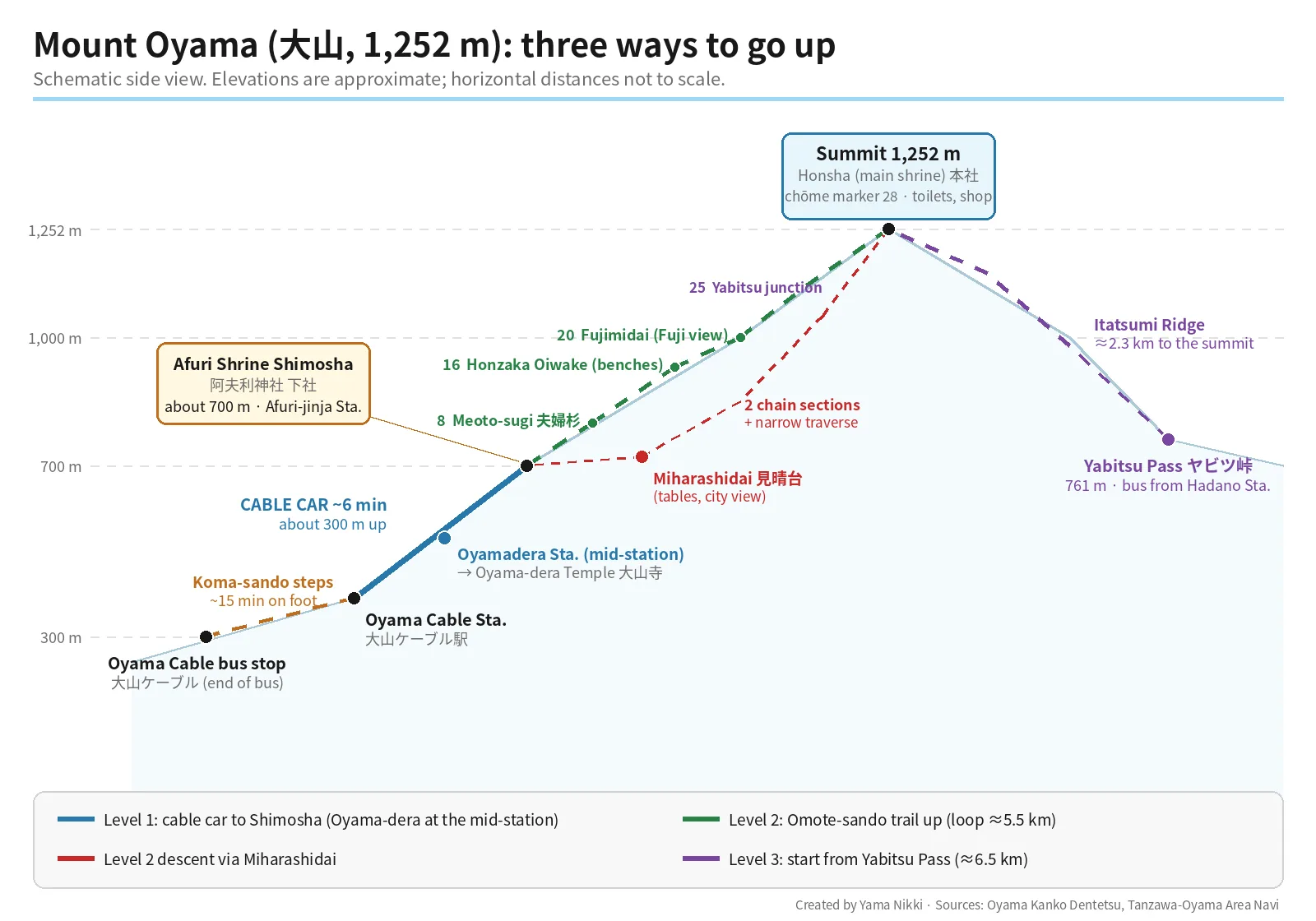
Pick your level
| Level 1: Shrine & temple | Level 2: Summit loop | Level 3: From Yabitsu Pass | |
|---|---|---|---|
| What you do | Cable car to Afuri Shrine Shimosha (阿夫利神社下社), stop at Oyama-dera Temple (大山寺) on the way | Cable car up, climb the Omote-sando trail (表参道) to the summit, descend via Miharashidai (見晴台) | Bus from Hadano to Yabitsu Pass (ヤビツ峠, 761 m), ridge walk to the summit, descend via Miharashidai |
| Walking | Stone steps around the shrine and temple, plus the Koma-sando steps from the bus stop | About 5.5 km, about 4 h 40 min including 1 h of rest | About 6.5 km, about 5 h 15 min including 1 h 15 min of rest |
| Trail notes | No mountain trail needed | Steep start, rocky steps, two chain sections and a narrow traverse on the way down | Some steep pitches and chains on the way up; quieter than the classic route |
| Good for | Families, shrine visitors, anyone short on time | First-time Oyama hikers with basic hiking shoes | Hikers who want a ridge walk and fewer people |
Walking distances and times for Levels 2 and 3 are from the Tanzawa-Oyama Area Navi pages for the Shimosha–Oyama route and the Yabitsu Pass–Oyama route.
Getting there: three legs
Leg 1 — Shinjuku → Isehara Station (Odakyu Line)
The operator’s access page gives about 60 minutes from Shinjuku (or about 30 minutes from Odawara) on the Odakyu Line to Isehara Station (伊勢原駅). If you want a reserved seat, Odakyu notes that you can add a limited express ticket and ride the Romancecar.
Leg 2 — Isehara Station → Oyama Cable bus stop (Kanachu bus)
- Go to the North Exit (北口) bus terminal, stop 4.
- Take a Kanagawa Chuo Kotsu (Kanachu, 神奈中) bus on route Isehara 10 (伊10) to “Oyama Cable” (大山ケーブル) or route Isehara 11 (伊11) “Oyama Cable (direct)”, and ride to the last stop.
- The ride is about 30 minutes. Area Navi lists the regular fare as 410 yen each way.
- Coming back, Area Navi says the Isehara 10 buses to Isehara Station North Exit run two to four times an hour.
There is a shoe brush and water tub near the information center by the bus stop for cleaning muddy boots before you board (Area Navi).
Leg 3 — Koma-sando on foot → Oyama Cable Station
From the bus stop it is about 15 minutes on foot up the Koma-sando (こま参道), a stepped lane of souvenir shops, tofu restaurants and workshops making Oyama koma spinning tops. The landings have tiles shaped like tops that count how many you have passed. Cars cannot drive up to the cable car station, and the operator warns that the lane is a long series of steps.
The Oyama Cable Car
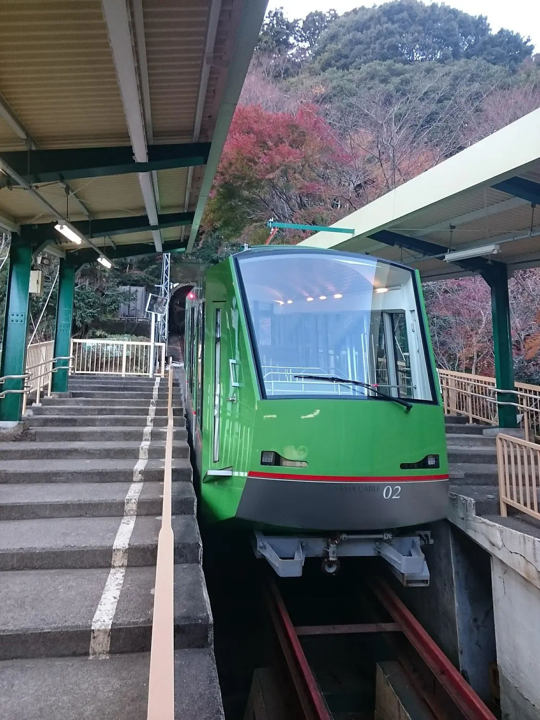

All figures below are from the operator’s timetable and fares page.
- Route: Oyama Cable Station (大山ケーブル駅) → Oyamadera Station (大山寺駅) → Afuri-jinja Station (阿夫利神社駅). End to end takes about 6 minutes; either end to Oyamadera takes about 2 minutes. The operator notes that Oyamadera is the only station in Japan’s cable cars built at the passing point where the two cars meet.
- Hours: weekdays 9:00–16:30, weekends and holidays 9:00–17:00. Cars leave both ends at :00, :20 and :40 past each hour (Oyamadera at :02, :22 and :42). The last weekday departure is at 16:30; on weekends and holidays extra cars run at 16:40 and 17:00. Extra cars are added when crowded, and hours are extended in the autumn-leaves season, New Year and Golden Week.
- Weather: service can be suspended in heavy rain, strong wind or lightning.
| Adult fares (child fares are half) | One way | Round trip |
|---|---|---|
| Oyama Cable ⇄ Afuri-jinja (stop at Oyamadera allowed) | 640 yen | 1,270 yen |
| Either end ⇄ Oyamadera (mid-station only) | 360 yen | 700 yen |
| One way with a Freepass B ticket | 580 yen | — |
Paying: at the ticket window you can use cash, credit cards, transit IC cards (Suica, PASMO and others) or PayPay. Tapping in at the gate works only with an EMot e-ticket or a contactless credit/debit card — transit IC cards cannot be tapped at the gate.
Level 1: Afuri Shrine Shimosha and Oyama-dera Temple
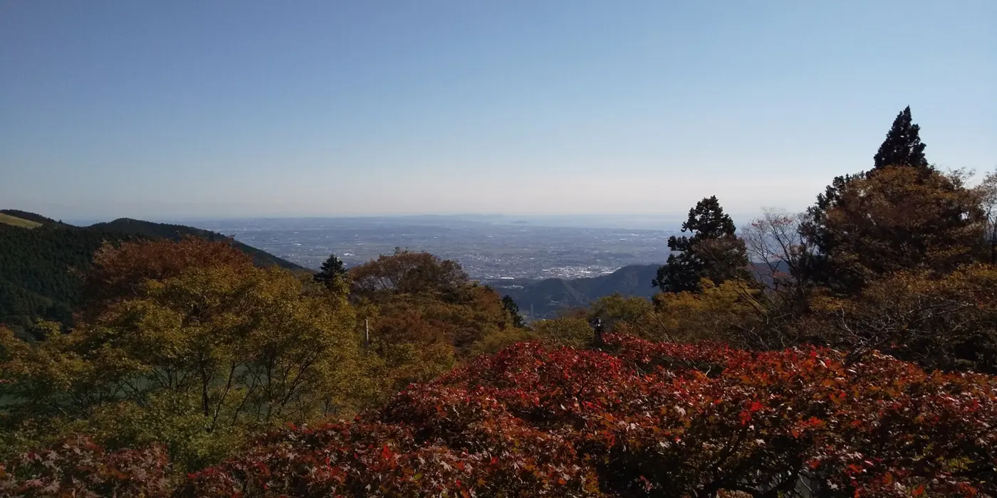

Afuri Shrine Shimosha (阿夫利神社 下社) is a short walk and a flight of stone steps from Afuri-jinja Station, at about 700 m. The shrine is said to have been founded over 2,200 years ago; the main shrine (Honsha) stands on the summit and the lower shrine (Shimosha) on the mountainside. The operator and Area Navi both point out that the view from the Shimosha — over the Sagami Plain to Sagami Bay, Enoshima and the Miura Peninsula, and on clear days the Boso Peninsula and Izu Oshima — is rated two stars in the Michelin Green Guide Japan. Spring water called Ōyama meisui (大山名水) flows from beneath the hall, and Area Navi suggests filling a bottle here before a hike.
Oyama-dera Temple (大山寺), at the mid-station, was founded in 755 and is affectionately called Ōyama no Fudō-san. The operator counts it among the three great Fudō temples of the Kanto region. Its iron statue of Fudō Myōō and two attendants, cast in the 13th century, is a national Important Cultural Property and is shown on the 8th, 18th and 28th of each month. Area Navi notes that you can walk from the Shimosha down to Oyama-dera by the Onna-zaka (女坂) path in about 20 minutes.
A gentle add-on that does not go to the summit: Area Navi’s Shimosha–Hinata Yakushi route passes the Nijū-no-taki waterfall (二重滝) and Miharashidai and then descends to Hinata Yakushi (日向薬師), about 6.6 km and 3 h 40 min, with very little climbing. From Hinata Yakushi, buses on route Isehara 20 (伊20) return to Isehara Station North Exit about once or twice an hour. It includes the same narrow traverse (under 1 m wide) between the waterfall and Miharashidai described below.
Level 2: The summit loop, marker by marker
Area Navi calls this the classic route for first-timers: up the Omote-sando from the Shimosha, down via Miharashidai. Stone markers called chōme (丁目) count the way: the Tohai-mon gate (登拝門) beside the Shimosha is No. 1, and the summit is No. 28.
| Marker | What you find there (Area Navi) |
|---|---|
| Tohai-mon (No. 1) | The trail starts left of the hall, past a purification spot, with over 100 steep stone steps |
| No. 8 — Meoto-sugi (夫婦杉) | Twin cedars, about 20 minutes up; tree roots and rocks follow |
| No. 16 — Honzaka Oiwake (本坂追分) | Halfway point with a wide space and benches — a good rest stop |
| No. 20 — Fujimidai (富士見台) | An open spot with a view of Mt. Fuji on clear days, about 30 minutes past No. 16. Big rocks and boardwalks can be slippery |
| No. 25 | Junction with the trail from Yabitsu Pass |
| No. 28 — Summit (1,252 m) | A torii gate, then the Honsha (main shrine), a shop, toilets and plenty of benches. The shop serves pork miso soup, mountain-vegetable soba and amazake on the days it is open |
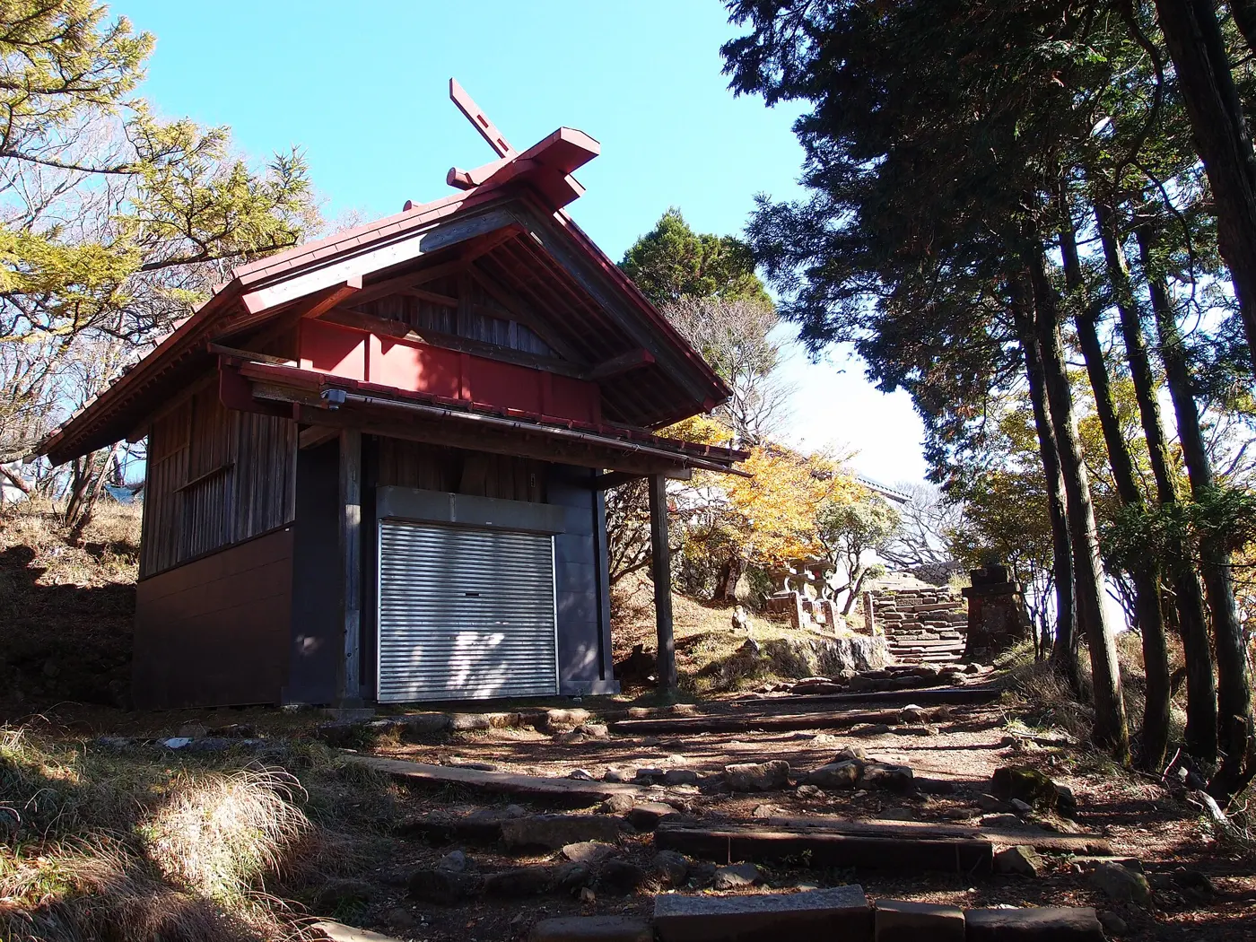

The way down: where to slow down
From the summit, follow the signs for “Miharashidai 2.2 km.” Area Navi describes the descent like this:
- Steps down to the Fudōjiri junction (不動尻分岐) — keep right.
- A narrow, gravelly section with chains and warning signs. There are two places with chains on bad footing. Area Navi’s advice: hold the chain with both hands, turn to face the slope, and climb down slowly.
- Miharashidai — tables, benches, and a view over central Tokyo and Yokohama.
- “Shimosha 1.4 km” — a narrow traverse under 1 m wide. Chains and ropes line the drop side, but Area Navi warns that they are not handrails, so don’t lean on them.
- You come out by the tea houses near the Shimosha, then take the cable car down — or walk down to Oyama-dera via the Onna-zaka.
If the chain sections sound like too much, you can come back down the Omote-sando the way you went up.
Level 3: Start high at Yabitsu Pass
Area Navi’s Yabitsu Pass route starts from Hadano Station (秦野駅), a few stops past Isehara on the Odakyu Line:
- From the North Exit, stop 4, take the Kanachu bus route Hadano 21 (秦21) to Yabitsu Pass, about 50 minutes. Climbing-plan forms and a submission box are next to the stop.
- Yabitsu Pass (761 m) has public toilets, a shop and a plan box. Area Navi notes there is no toilet for over an hour after that, until the summit.
- Follow the sign “Oyama 2.3 km” up the Itatsumi Ridge (イタツミ尾根), joining the Omote-sando at marker No. 25.
- Descend via Miharashidai (with the same chain sections as Level 2) to the Shimosha, then, as Area Navi suggests, walk the Onna-zaka down to Oyama-dera and ride the cable car from the mid-station.
Area Navi lists this route at about 6.5 km and 5 h 15 min including rest, and says it has fewer hikers than the classic route, a relatively gentle trail with steep pitches and chains in places, and many benches along the way. Check the Kanachu timetable for the Yabitsu Pass bus before you set out.
Does the Tanzawa-Oyama Freepass pay off?
Odakyu’s Tanzawa-Oyama Freepass is a 2-day pass from Shinjuku that includes a round trip on the Odakyu Line, unlimited rides on the Odakyu Line between Hon-Atsugi and Shibusawa, Kanachu buses in a set area, and — with the A ticket only — the Oyama Cable Car. The B ticket leaves out the cable car. Showing the pass also gets you discounts at more than 20 places in the area, including hot springs, shops and restaurants.
Area Navi works through the numbers for the classic summit loop from Shinjuku using regular fares:
| Item (adult, regular fare) | Yen |
|---|---|
| Odakyu Line, Shinjuku → Isehara | 610 |
| Kanachu bus, Isehara Sta. → Oyama Cable | 410 |
| Oyama Cable Car, round trip | 1,270 |
| Kanachu bus, Oyama Cable → Isehara Sta. | 410 |
| Odakyu Line, Isehara → Shinjuku | 610 |
| Total at regular fares | 3,310 |
| Tanzawa-Oyama Freepass A ticket | 2,520 |
That is 790 yen less with the A ticket for this exact trip (Area Navi). The math changes if you start from somewhere other than Shinjuku, so compare with your own route. Odakyu lists the child price as 920 yen, and the pass can be bought online as an EMot e-ticket.
For the Yabitsu Pass route, which uses the cable car only for the ride down from the Oyamadera mid-station, Area Navi pairs the cheaper B ticket (1,560 yen) with that 360-yen fare. B-ticket holders also get the 580-yen one-way fare for the full cable car line.
Late autumn on Oyama
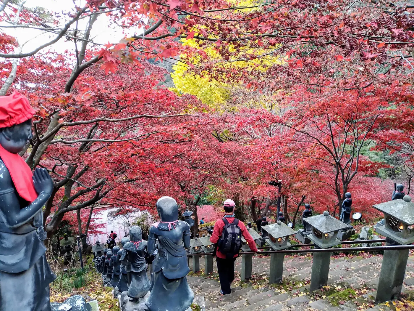

- Leaves: Area Navi says the autumn color starts near the summit and works its way down. At Oyama-dera, red maples cover the stone steps in front of the main hall, and the operator says they are usually at their best around mid-to-late November, when an evening light-up is held, with special night runs of the cable car. Dates for 2026 are announced by the operator and Area Navi; check their notices before planning an evening visit.
- Crowds and parking: The operator warns that the terrain leaves little room for parking and asks visitors to come by public transport. The two municipal lots near the bus stop hold 84 cars (Lot 1, 600 yen a day) and 44 cars (Lot 2, 1,000 yen a day).
- Short days: The operator asks everyone to carry a light even on a daytime hike, and to use one on the trail after sunset. Work backward from the last cable car (16:30 on weekdays, 17:00 on weekends and holidays, unless extended).
- Bears: Kanagawa Prefecture says the Tanzawa Mountains are Japanese black bear habitat and you could meet a bear anywhere in them. Its fiscal 2026 list of sightings, updated on October 13, 2026, includes repeated reports from the Oyama and Hinata districts of Isehara City. The prefecture advises avoiding early morning, evening and fog, hiking in pairs or groups, and carrying a bell, whistle or radio; if you meet a bear, don’t run, don’t shout or throw things, and back away slowly while facing it (Kanagawa Prefecture). See also our bear safety guide.
After the hike: a soak at Tsurumaki Onsen
On the way back to Tokyo, Tsurumaki-Onsen Station (鶴巻温泉駅) is between Isehara and Hadano on the Odakyu Line, inside the Freepass free-ride section. Kōbō-no-Sato-yu (弘法の里湯), a city-run day spa, is 2 minutes on foot from the station. According to Hadano City:
- Open 10:00–21:00 (last entry 20:00). Closed Mondays (the next weekday if Monday is a holiday) and December 31.
- Adults: 2 hours 1,000 yen on weekends and holidays; on weekdays 800 yen for 2 hours or 1,000 yen for the day. Children of elementary and junior-high age pay half; preschoolers are free.
- 200 yen off if you show the Tanzawa-Oyama Freepass at reception.
- Two hot-spring sources: the outdoor bath and the indoor bath use different springs.
Before you go
- Footwear: Area Navi describes the summit trails as rocky with many steep steps. The operator recommends sturdy-soled hiking shoes, a spare shirt and warm layer, and rain gear because the weather changes quickly.
- Climbing plan (登山計画書): The operator lists plan boxes at the Isehara Station police box, the Oyama tourist information center and Oyama Cable Station. The Kanagawa Prefectural Police also explain how to submit a plan online through Compass (Kanagawa Police).
- Toilets: The toilets inside Oyama Cable Station are only open during cable car hours (operator). There are toilets at the summit.
- Leave no trace: Don’t pick or damage plants, don’t feed wild animals, and carry your trash home (operator).
- Basics for visitors: Japan hiking rules basics covers emergency numbers, rescue costs and insurance.
How Oyama compares with other Tokyo day trips
- Mt. Takao day trip from Tokyo — closer and gentler, reached directly from Shinjuku on the Keio Line.
- Mt. Mitake day trip from Tokyo — another cable car and shrine village, in western Tokyo.
- Mount Tsukuba day trip from Tokyo — twin peaks and a ropeway, northeast of Tokyo.
- Mt. Daibosatsu day hike from Tokyo — a higher ridge in Yamanashi for more experienced hikers.
Oyama sits in between: the cable car makes the shrine easy, but the summit is a real climb of about 550 m from the Shimosha, with chains on the way down.
Japanese-language guides on this site (useful for kanji names): 大山 登山ガイド and, for the wider Tanzawa range, 丹沢山登山ガイド.
References
- Oyama Kanko Dentetsu — Oyama Cable Car (top page)
- Oyama Cable Car — Timetable and fares
- Oyama Cable Car — Access (train, bus, Koma-sando, parking)
- Oyama Cable Car — Walking and hiking map, safety advice
- Oyama Cable Car — About Oyama (Oyama-dera, Afuri Shrine)
- Tanzawa-Oyama Area Navi — Shimosha–Oyama route
- Tanzawa-Oyama Area Navi — Yabitsu Pass–Oyama route
- Tanzawa-Oyama Area Navi — Shimosha–Hinata Yakushi route
- Tanzawa-Oyama Area Navi — News and events
- Odakyu — Tanzawa-Oyama Freepass (English)
- Kanagawa Chuo Kotsu (Kanachu bus)
- Oyama-dera Temple (official site, Japanese)
- Kanagawa Prefecture — Japanese black bear information
- Kanagawa Prefectural Police — Mountain safety and climbing plans
- Hadano City — Kōbō-no-Sato-yu