
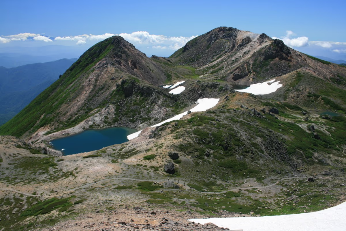
Photo: Alpsdake, Wikimedia Commons (CC BY-SA 3.0)

Mt. Hakusan Hiking Guide: Climbing One of Japan's Three Sacred Mountains via the Sabo Shindo Trail and Alpine Flower Meadows
Complete hiking guide to Mt. Hakusan (Gozenmine, 2,702 m) on the Ishikawa–Gifu border. Covers the classic Sabo Shindo and Kanko Shindo trails from Betto Deai, alpine wildflowers across Midagahara, the Oike-meguri crater-lake circuit, private car restrictions at Ichinose, and access from Kanazawa and Kansai.
Overview: One of Japan's Three Sacred Mountains and a Botanical Treasure House
Rising to 2,702 meters on the border of Ishikawa and Gifu Prefectures, Mt. Hakusan (Haku-san) is revered alongside Mt. Fuji and Mt. Tateyama as one of Japan's Three Sacred Mountains (Nihon Sanreizan) and is a centerpiece of the 100 Famous Japanese Mountains (Nihon Hyakumeizan). Its broad volcanic crown consists of three main peaks—Gozenmine (2,702 m), Onanjimine (2,684 m), and Kengamine (2,677 m)—ringing a cluster of emerald crater lakes known as the Oike ponds.
Mt. Hakusan is also celebrated across Japan for the sheer diversity of its alpine flora. Heavy winter snows brought by Sea of Japan winds melt slowly through early summer, feeding sprawling alpine meadows at Midagahara and Nanryugababa. So many alpine plant species were first documented here that over twenty Japanese botanical names begin with Hakusan-—including Hakusan-kozakura (Primula cuneifolia var. hakusanensis), Hakusan-ichige, and Hakusan-fuuro, alongside famous colonies of dark purple kuroyuri (chocolate lilies, Fritillaria camschatcensis).
Quick Facts
| Item | Details |
|---|---|
| Location | Hakusan City, Ishikawa Prefecture / Shirakawa Village, Ono District, Gifu Prefecture |
| Highest Peak | Gozenmine (2,702 m) |
| Designations | Hakusan National Park, 100 Famous Japanese Mountains, Three Sacred Mountains |
| Difficulty | Intermediate (well-maintained trail, but ~1,440 m elevation gain and 14+ km round trip) |
| Round-Trip Time | Approx. 7 to 9 hours via the Sabo Shindo Trail from Betto Deai |
| Main Trailhead | Betto Deai (1,260 m, Ishikawa side) |
| Access & Regulations | Private car restrictions apply on weekends/holidays and peak summer dates between Ichinose and Betto Deai (park at Ichinose and take shuttle bus) |
| Restrooms | Betto Deai, Nakahanba, Jinnosuke Shelter Hut, Murodo Visitor Center |
| Mountain Huts | Hakusan Murodo (2,450 m, reservation required; open roughly July–mid-October), Nanryu Sanso |


Essential Planning Points Before You Climb
1. Over 1,440 Meters of Elevation Gain
Starting from Betto Deai (1,260 m) and climbing to Gozenmine (2,702 m) requires 1,442 meters of vertical gain over a round-trip distance of roughly 14 km (7 to 9 hours of walking). Unlike ropeway-assisted alpine peaks such as Mt. Kisokomagatake or Mt. Norikura, every meter above Betto Deai is climbed on foot. If you plan to hike Mt. Hakusan as a single-day push, start walking by 04:00–05:00 AM; otherwise, reserve an overnight stay at Hakusan Murodo (2,450 m) to enjoy sunset, sunrise, and the crater-lake loop at a relaxed pace.
2. Private Car Restrictions Between Ichinose and Betto Deai
During the main summer and autumn climbing season (typically weekends, public holidays, and peak Obon periods from July through early October), Prefectural Route 33 between Ichinose and Betto Deai is closed to private vehicles to prevent severe congestion.
- When restrictions are in effect, park at the large free parking lot near Ichinose Visitor Center and ride the connecting shuttle bus to Betto Deai (approx. 15–20 minutes).
- Because restriction dates and first-bus times are updated each season, always verify the official schedule on the Hakusan City Official Website or Ishikawa Prefecture Hakusan Page.
3. Active Volcano Information (JMA Alert Level 1)
Mt. Hakusan is an active volcano monitored by the Japan Meteorological Agency. Check current volcanic activity notices before departure.
4. Best Season: Early July to Mid-October
Heavy snow lingers in gullies through June. The standard summer hiking season without snow gear runs from early July (after the July 1 Natsuyama Kaizan opening) through mid-October, with alpine wildflowers peaking from mid-July to early August and autumn foliage coloring the slopes from late September to early October.
Recommended Routes from Betto Deai
Route 1: Sabo Shindo Round Trip (Most Popular & Beginner-Friendly)
Betto Deai (1,260 m) → Nakahanba (1,550 m) → Jinnosuke Shelter Hut (1,970 m) → Nanryu Junction → Kuroboko Iwa (2,320 m) → Midagahara → Murodo (2,450 m) → Gozenmine Summit (2,702 m) → Return via same route
- Walking Time: Approx. 7 to 9 hours round trip
- Distance: Approx. 14 km round trip
- Cumulative Elevation Gain: Approx. 1,500 m
| Waypoint | Elevation | Segment Time |
|---|---|---|
| Betto Deai Trailhead | 1,260 m | Start |
| Nakahanba Rest Area | ~1,550 m | ~60 min |
| Jinnosuke Shelter Hut | ~1,970 m | ~70 min |
| Nanryu Trail Junction | ~2,100 m | ~20 min |
| Kuroboko Iwa Rock | 2,320 m | ~20 min |
| Midagahara Boardwalks | ~2,380 m | ~15 min |
| Murodo (Hakusan Murodo Visitor Center) | 2,450 m | ~20 min |
| Gozenmine Summit | 2,702 m | ~50 min |
| Murodo | 2,450 m | ~35 min (descent) |
| Jinnosuke Shelter Hut | ~1,970 m | ~50 min |
| Betto Deai Trailhead | 1,260 m | ~100 min |
After crossing the dramatic suspension bridge at Betto Deai, the Sabo Shindo Trail climbs steadily through beech forest and stone steps to the Nakahanba and Jinnosuke Shelter Hut rest stops (both equipped with restrooms). Above Jinnosuke, the view opens up as you switchback up to Kuroboko Iwa (2,320 m), the gateway to the alpine plateau.
Crossing the level boardwalks of Midagahara brings you to Murodo (2,450 m), home to the visitor center, mountain lodge, and Shirayamahime Shrine prayer hall. From Murodo, a final 50-minute climb up stone-paved alpine switchbacks leads to the summit of Gozenmine (2,702 m).
Route 2: Sabo Shindo Ascent & Kanko Shindo Descent Loop
Betto Deai → [Sabo Shindo] → Murodo → Gozenmine (2,702 m) → Murodo → Kuroboko Iwa → [Kanko Shindo via Tonogaike Shelter Hut] → Betto Deai
- Walking Time: Approx. 8 to 10 hours
- Distance: Approx. 15–16 km
The Kanko Shindo Trail follows an open ridge between Kuroboko Iwa and Betto Deai, offering wider views and abundant alpine flowers around the Horse's Mane (Uma-no-tategami) ridge. However, its lower section features steep, rocky steps with no water sources, making it best used as a fair-weather descent route after ascending the Sabo Shindo, or by hikers staying overnight at Murodo.
The Oike-Meguri Crater-Lake Circuit and Highlights
1. Oike-Meguri (Crater-Lake Circuit) and Midorigaike
Just below the summit of Gozenmine lies a volcanic landscape dotted with snowmelt ponds, including emerald-green Midorigaike, iron-tinged Chinoike, and snow-filled Senjagaike. Extending your walk from Gozenmine around the lakes and optionally up Onanjimine (2,684 m) back to Murodo adds roughly 1 to 1.5 hours.


2. Midagahara Alpine Flower Meadows and Kuroyuri
From mid-July through August, the wet meadows around Midagahara and Murodo bloom with pink Hakusan-kozakura, white chrysanthemum-like Hakusan-ichige, tall kobaikeiso, and clusters of dark-purple kuroyuri (chocolate lilies). Stepping off the boardwalks is strictly prohibited to protect the fragile alpine turf.


3. Shirayamahime Shrine Okumiya and 360-Degree Views
Atop Gozenmine stands the Okumiya (summit shrine) of Shirayamahime Shrine, marking over 1,300 years of sacred mountain worship. On clear mornings, the summit panorama spans the entire Northern Japanese Alps (Tateyama, Tsurugidake, Yarigatake, Hotakadake), Mt. Ontake, Mt. Norikura, the Sea of Japan, and the Noto Peninsula.


Clothing and Gear Checklist
At 2,702 meters, summer summit temperatures frequently drop to 10°C or lower, and afternoon thunderstorms or strong westerly winds from the Sea of Japan can arrive rapidly.
- Clothing (Layering Guide):
- Quick-dry base layer (the lower forest climb from Betto Deai is warm and humid in summer)
- Fleece or packable insulated jacket for Murodo and the summit ridge
- Waterproof breathable rain suit (essential wind and rain protection)
- Mid- or high-cut hiking boots with ankle support for the 1,440 m descent
- Sun hat, sunglasses, sunscreen, and gloves
- Essential Gear (Day-Hike Checklist):
- 1.5 to 2.0 L of water and high-calorie trail snacks
- Trekking poles (with rubber tip protectors so you do not damage wooden boardwalks)
- Headlamp with spare batteries (essential for early-morning starts)
- Offline GPS map and power bank
Access and Restrooms
- By Car: From the Hokuriku Expressway (Hakusan IC or Komatsu IC), follow Route 157 and Prefectural Route 33 to Ichinose (and on to Betto Deai on non-restricted weekdays). From Osaka or Kyoto, driving takes roughly 3.5 to 4 hours via the Meishin and Hokuriku Expressways.
- By Public Transit: Seasonal direct hiking buses (Hakusan Tozan Bus) operate between JR Kanazawa Station and Ichinose / Betto Deai during the summer climbing season. Check current operating dates and timetables via Hakusan City or the Urara Hakusanbito (Hakusan Tourism Association) website.
- Restrooms: Available at Betto Deai, Nakahanba, Jinnosuke Shelter Hut, and Murodo (none between Murodo and Gozenmine).