
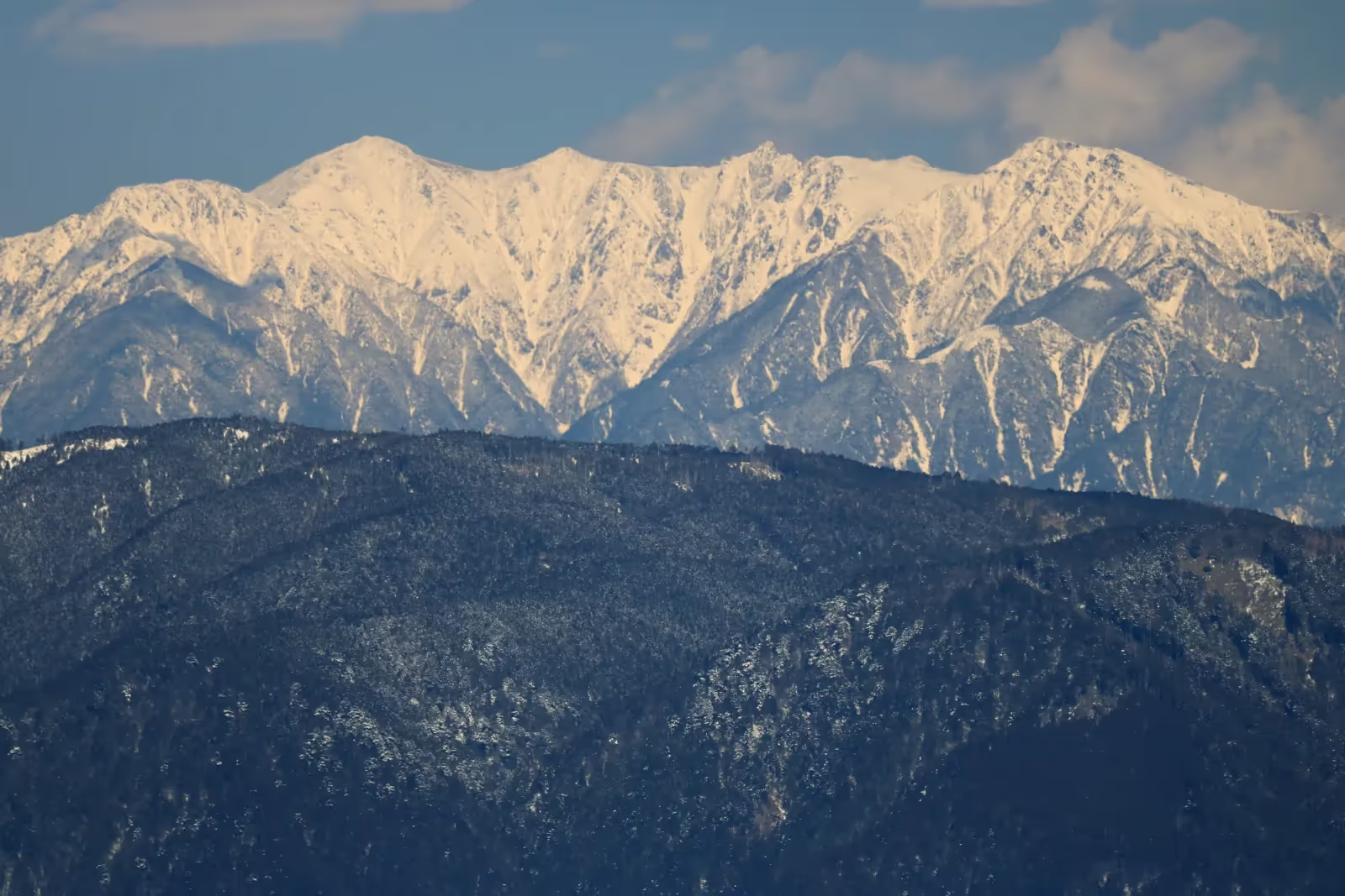
Photo: Alpsdake, Wikimedia Commons (CC BY-SA 3.0)

Mt. Kisokomagatake Hiking Guide: Ropeway Access to Senjojiki Cirque and the 2,956 m Central Alps Summit
Complete guide to hiking Mt. Kisokomagatake (2,956 m), the highest peak in the Central Alps (Kiso Mountains). Covers the bus and Komagatake Ropeway access to Senjojiki Station (2,612 m), the Hachobori slope, Nagano Prefecture difficulty grade, Suganodai parking fees, and seasonal gear.
Rising to 2,956 m in Nagano Prefecture, Mt. Kisokomagatake (木曽駒ヶ岳) is the highest peak of the Central Alps (Kiso Mountains) and one of the 100 Famous Japanese Mountains (Nihon Hyakumeizan).
What makes Mt. Kisokomagatake unique among Japan's near-3,000 m peaks is its access: by taking the route bus from Suganodai Bus Center (菅の台バスセンター) to Shirabidaira (しらび平) and riding the Komagatake Ropeway, you reach Senjojiki Station at 2,612 m (千畳敷駅)—the highest ropeway station in Japan—in roughly 40 minutes of transit time. From the station terrace, you step directly into the glacial amphitheater of Senjojiki Cirque (千畳敷カール), with only about 344 m of net elevation gain and 3.5 to 4 hours of round-trip walking to the 2,956 m summit.
Despite the short walking time, the trail climbs the steep, rocky headwall of Hachobori (八丁坂) and crosses wind-exposed alpine ridges nearly 3,000 m above sea level. In the Nagano Prefecture Trail Grading Matrix, the Senjojiki Station–Kisokomagatake round trip is rated Stamina Level 2 / Technical Difficulty B. This guide covers the verified route details, access, Suganodai parking rules, seasonal highlights, and high-altitude safety precautions.


Overview of Mt. Kisokomagatake
| Item | Details |
|---|---|
| Elevation | 2,956 m (Highest peak in the Central Alps / Kiso Mountains) |
| Location | Kiso Town, Agematsu Town, Miyada Village & Ina City, Nagano Prefecture |
| Starting Elevation | 2,612 m (Senjojiki Station, Komagatake Ropeway) |
| Net Elevation Gain | Approx. 344 m (Cumulative elevation gain approx. 450 m including Mt. Nakadake ups and downs) |
| Standard Walking Time | Approx. 3 hr 30 min – 4 hr round trip (Ascent ~2 hr / Descent ~1 hr 30 min) |
| Distance | Approx. 3.8 km round trip |
| Nagano Trail Grade | Stamina 2 / Technical Difficulty B (Senjojiki Station – Kisokomagatake round trip) |
| Best Summer/Autumn Season | Mid-July to Early October (July–August for alpine flowers; late September–early October for autumn foliage) |
| Restrooms | Senjojiki Station, Bugaike Junction (portable toilet booth area), Hojo Sanso / Chojo Sanso area (paid mountain toilets; bring 100 JPY coins) |
| Mountain Huts | Hotel Senjojiki, Komagatake Hojo Sanso, Komagatake Chojo Sanso, Chojo Kiso-goya, Tamakino-koya |
Why Hike Mt. Kisokomagatake?
1.Senjojiki Cirque — A Glacial Bowl Carved Out 20,000 Years Ago
Directly in front of Senjojiki Station spreads Senjojiki Cirque (千畳敷カール), a dramatic semicircular basin sculpted by glacial ice roughly 20,000 years ago during the last glacial period. Its name ("One Thousand Tatami Mats") comes from its vast, bowl-like floor, which transforms into one of Japan's premier alpine flower gardens in late July and August and blazes with red rowan and golden birch foliage in late September and early October. Looking up from the cirque floor at the rugged granite towers of Mt. Hoken (宝剣岳, 2,931 m) is an unforgettable alpine sight.

2. A 360-Degree Panorama of Japan's Major Mountain Ranges
From the broad, gravelly summit of Mt. Kisokomagatake (2,956 m), you stand at the top of the Central Alps with unobstructed views in every direction on clear days:
- East: The entire wall of the Southern Alps (Mt. Kitadake, Mt. Ainodake, Mt. Senjogatake, Mt. Kaikomagatake), the Yatsugatake range, and Mt. Fuji rising behind them
- North: The Northern Alps (the Hotaka range, Mt. Yarigatake, Mt. Norikuradake)
- West: Massive Mt. Ontake (3,067 m) across the Kiso Valley
- South: The long ridge of the Central Alps stretching toward Mt. Utsugidake (2,864 m)
3. Approachable 3,000 m Terrain Enabled by the Komagatake Ropeway
Climbing to nearly 3,000 m from a valley trailhead normally requires a multi-day trek or more than 1,500 m of vertical ascent. On Mt. Kisokomagatake, the combination of the mountain bus and the Komagatake Ropeway carries you across a 950 m vertical rise in just 7 minutes 30 seconds from Shirabidaira (1,662 m) to Senjojiki Station (2,612 m). That makes a day trip feasible for well-prepared hikers, provided you allow buffer time for ropeway queues.
Standard Route Guide: Senjojiki Station to Mt. Kisokomagatake Round Trip
Senjojiki Station (2,612 m)
  │ Approx. 50 min (cirque floor path + steep rocky steps of Hachobori)
  ▼
Bugaike Junction / Nokkoshi-jodo (2,858 m)
  │ Approx. 30 min (open ridgeline over Mt. Nakadake)
  ▼
Mt. Nakadake (2,925 m)
  │ Approx. 40 min (brief descent to saddle, then final climb to summit)
  ▼
Mt. Kisokomagatake Summit (2,956 m)
  │ Approx. 1 hr 30 min (retrace route back to Senjojiki Station)
  ▼
Senjojiki Station (2,612 m)
Section 1: Senjojiki Station to Nokkoshi-jodo (Bugaike Junction) — Approx. 50 min
Before stepping onto the trail from Senjojiki Station (2,612 m), submit your climbing plan at the station registration box (or ahead of time via Compass) and spend 15 to 30 minutes acclimatizing to the thin air at 2,600 m.
The path descends briefly onto the floor of Senjojiki Cirque, passing alpine meadows before reaching the foot of Hachobori (八丁坂)—the steepest and most demanding section of the entire climb. Hachobori is a rocky, zig-zagging stone-stepped path that climbs the headwall of the cirque with roughly 250 m of vertical gain.


Key Tips for Hachobori:
- Keep a slow, steady rhythm: You are already above 2,600 m; bounding up the steps right after leaving the ropeway is the fastest way to trigger shortness of breath or altitude sickness.
- Yield safely in narrow spots: On sunny summer and autumn weekends, Hachobori sees steady two-way traffic. Ascending hikers generally have priority, so wait at stable flat steps when passing.
- Avoid kicking loose stones: Step squarely on solid rocks and wear proper high-cut or mid-cut hiking boots.
Section 2: Nokkoshi-jodo to Mt. Nakadake (2,925 m) — Approx. 30 min
Topping out at the top of Hachobori brings you onto the windy saddle of Nokkoshi-jodo (乗越浄土, 2,858 m), where Hojo Sanso (宝剣山荘) and Tenguso (天狗荘) stand. Cold wind frequently funnels across this pass even when the cirque below felt calm and warm, so stop here to put on a windproof shell before continuing along the ridge.
(Note: Turning left at Nokkoshi-jodo leads toward Mt. Hoken (宝剣岳, 2,931 m), an exposed class-D rock scramble with chains and sheer drops where fatal falls occur; beginner and intermediate hikers should turn right toward Mt. Nakadake and Mt. Kisokomagatake.)
Turning right (north) from Nokkoshi-jodo, the broad granite trail climbs gently across open alpine terrain to the boulder-strewn top of Mt. Nakadake (中岳, 2,925 m).
Section 3: Mt. Nakadake to Mt. Kisokomagatake Summit (2,956 m) — Approx. 40 min
From Mt. Nakadake, the trail drops briefly into a saddle where Komagatake Chojo Sanso (駒ヶ岳頂上山荘) and its tent site sit, then climbs the final gravel-and-rock slope to the summit of Mt. Kisokomagatake (2,956 m).


At the spacious summit sit the Kiso-Komagatake Shrines (Ina and Kiso shrines) and the triangulation point, surrounded by 360-degree views of the Southern Alps, Mt. Fuji, the Northern Alps, and Mt. Ontake.
Section 4: Descent (Summit to Senjojiki Station) — Approx. 1 hr 30 min
Retrace your steps over Mt. Nakadake to Nokkoshi-jodo and descend Hachobori carefully. Most slips and twisted ankles on Mt. Kisokomagatake happen on the descent down Hachobori, when tired legs step down high rock risers. Use trekking poles with rubber tips to reduce knee impact, and keep plenty of margin before the final afternoon ropeway departure.
Access, Private Car Restrictions & Suganodai Parking
Because the mountain road beyond Kurokawa-daira (黒川平) up to Shirabidaira Ropeway Station (しらび平駅) is closed to private vehicles year-round to protect the alpine environment, all drivers and rail travelers transfer to the official route bus at Suganodai Bus Center (菅の台バスセンター).
By Car (via Chuo Expressway Komagane IC)
- Exit the Chuo Expressway at Komagane IC (
駒ヶ根IC) and drive approx. 3 minutes (about 2 km) west to Suganodai Bus Center (菅の台バスセンター). - Suganodai Bus Center Parking (Official Komagane City / Tourism Association figures):
- Capacity: 300 standard cars (plus overflow temporary lots opened during peak periods)
- Hours: Open 24 hours (automated payment gate; supports cash and credit/transit cards)
- Parking Fees (per 24 hours):
- Standard car (
普通車): 800 JPY - Mid-size vehicle (
中間車/ microbus): 1,000 JPY - Large bus (
大型車): 1,500 JPY - Motorcycle (
自動二輪): 200 JPY - (Note: Camper vans are charged as standard cars if under 5 m long, or mid-size if 5 m or longer.)
- Standard car (
- Walk to the adjacent ticket counter to buy a combined Bus + Ropeway Round-Trip Ticket, board the bus to Shirabidaira (approx. 30 min), and transfer to the Komagatake Ropeway (7 min 30 sec) to Senjojiki Station.
By Train and Bus
- Take the JR Iida Line to Komagane Station (
駒ヶ根駅) (or take an express highway bus from Shinjuku, Nagoya, or Osaka to Chuo-do Komagane IC (中央道駒ヶ根インター) or Komagane Bus Terminal). - Board the Ina Bus / Chuo Alps Kanko route bus bound for Shirabidaira (
しらび平) from Komagane Station (approx. 45 min; stops at Suganodai Bus Center after ~15 min), then ride the Komagatake Ropeway (7 min 30 sec) to Senjojiki Station.
Avoiding Peak Ropeway Waiting Times
During the summer alpine flower peak (late July to mid-August) and the autumn foliage peak (late September to early October), weekend waits for the bus and ropeway can reach 1 to 2+ hours each way:
- Arrive at Suganodai Bus Center around 5:00–6:00 AM on peak weekends, when extra early-morning buses and ropeway runs are often added.
- Avoid heading back to Senjojiki Station right at the 2:00–4:00 PM rush: Aim to finish your hike and reach Senjojiki Station by 12:30–1:00 PM so you can get a numbered boarding pass (
整理券) before afternoon queues build up.
Seasonal Highlights and Snow Warnings
Golden Week through June: Full Snow-Mountain Conditions (12-Point Crampons + Ice Axe Required)
Because the ropeway operates year-round, visitors sometimes assume Senjojiki Cirque is a spring walk in May or June. In reality, as the Komagane Tourism Association and Nagano Prefectural Police emphasize, Senjojiki Cirque and Hachobori remain buried under deep snow from November right through June. Climbing above the cirque in May or June requires 12-point crampons, an ice axe, a helmet, winter mountaineering boots, and snow-climbing skills. Without full winter gear, stay on the snow-groomed viewing area right by Senjojiki Station.
Mid-July to August: Peak Summer Season and Alpine Flowers
By mid-July, most snow disappears from the main trail (though small snow patches can linger in the cirque). Over 150 species of alpine plants—including Chinguruma (Aleutian avens), Koma-usuyukiso (Central Alps edelweiss), and Shinano-kinbai (trollius)—bloom across Senjojiki Cirque and the upper ridges. Afternoon thunderclouds build frequently in August, so aim to summit in the morning and return to the ropeway before early afternoon.
Late September to Early October: Autumn Foliage
From late September to early October, Senjojiki Cirque turns brilliant red, orange, and gold against white granite crags and blue autumn skies. Morning temperatures at 2,600–2,956 m already drop close to 0 °C, and frost or rime ice can form overnight.
Mid-October Onward: Early Snowfall and Winter Transition
First snow (初冠雪) on Mt. Kisokomagatake typically arrives around mid-October. Once new snow or ice coats the steep rock steps of Hachobori, three-season boots alone are no longer safe.
Essential Safety Points and Gear Checklist
1. Prevent Altitude Sickness After the Rapid 950 m Ropeway Ascent
The Komagatake Ropeway lifts you nearly 1,000 vertical meters in 7.5 minutes to 2,612 m, where atmospheric oxygen is roughly three-quarters of sea-level pressure:
- Rest and walk slowly around Senjojiki Station for 15–30 minutes before starting up the trail.
- Drink fluids proactively before and during the climb.
- Breathe deeply and pace yourself slowly on Hachobori. If headache, nausea, or dizziness develops and does not ease with rest, turn back immediately to Senjojiki Station and descend on the ropeway.
2. Dress for Sub-10 °C Winds Even in Midsummer
At nearly 3,000 m, ambient air temperature is roughly 18 °C cooler than in the valley, and every 1 m/s of wind lowers the felt temperature by roughly 1 °C. Even in July and August, a windy ridge at Nokkoshi-jodo or Mt. Nakadake can feel like 5 °C or colder:
- Footwear: Broken-in mid- or high-cut waterproof hiking boots (never sneakers or sandals)
- Outer shell: Waterproof, breathable rain jacket and rain pants (essential as a windbreaker on the ridge)
- Insulation: Fleece or packable down jacket + quick-dry base layer (avoid cotton)
- Accessories: Windproof gloves, warm hat, sun hat, high-UV sunglasses, sunscreen, headlamp (in case of fog or delays), mobile power bank, 1.5 L+ water, high-energy trail snacks, and 100 JPY coins for mountain toilets.
Summary
Mt. Kisokomagatake offers one of the most rewarding alpine experiences in Japan: stepping out of Japan's highest ropeway station at 2,612 m directly into Senjojiki Cirque and climbing to a 2,956 m Hyakumeizan summit in roughly 3.5 to 4 hours of walking. Respect the 3,000 m alpine weather, budget time for the Suganodai bus and ropeway transfers, and enjoy the sweeping views from the roof of the Central Alps.
Reference Links
- Komagane Tourism Association — Senjojiki Cirque Official Guide
- Komagane Tourism Association — Central Alps Climbing Information
- Komagane Tourism Association — Frequently Asked Questions (Suganodai Parking & Access)
- Komagane City Official Site — Mt. Kisokomagatake & Senjojiki Cirque
- Ina Bus Official Site — Komagatake Ropeway Line Bus
- Nagano Prefecture — Nagano Trail Grading System
- Nagano Prefecture — Trail Grading Matrix PDF
- Nagano Prefecture — Winter Mountain Safety Guidebook PDF
- Nagano Prefectural Police — Mountain Rescue Case File No. 7 (Central Alps)