

Photo: 9689tatsuya, Wikimedia Commons (CC BY 4.0). Mt. Nasu in autumn colors.

Mt. Nasu (Chausudake) Hiking Guide: With or Without the Ropeway, Asahidake, and Autumn Traffic in 2026
How to plan a day hike up Mt. Nasu (Chausudake, 1,915 m) in Tochigi. Compares the ropeway route and the walk from Toge-no-Chaya, adds Asahidake, and covers 2026 ropeway hours and fares, autumn traffic measures, parking, the bus, volcano status, and getting there from Tokyo, based on Nasu Town, the ropeway, Tochigi Prefecture and the Japan Meteorological Agency.
This guide is based on official pages from the Nasu Ropeway, Nasu Town, Tochigi Prefecture and the Japan Meteorological Agency (information as of October 2026). Ropeway operation, traffic measures and bus timetables can change, so check them again before you go.
Mt. Nasu (那須岳, Nasu-dake) is the name for the Nasu volcanic range in Tochigi Prefecture. Day hikers usually mean its main peak, Chausudake (茶臼岳, 1,915 m). A ropeway lifts you most of the way up, which makes it one of the easier peaks in Japan's "100 Famous Mountains" to plan. It is also a popular autumn foliage area, and on fine weekends in October the roads below the mountain can be badly jammed.
This guide first helps you choose a route, then covers the ropeway, the walk without it, Asahidake, parking and buses, and what to watch for on the mountain.
Which route should you choose?
| If you want to | Route | Walking time (official model course or sum of section times) | Start |
|---|---|---|---|
| Reach the summit quickly | Ropeway, then Chausudake round trip | 1 h 38 min including the 4-minute ropeway each way (Nasu Town model course) | Ropeway base station |
| See autumn color on the slopes | Ropeway summit station to Ubagadaira and back | 2 h 13 min including the ropeway (Nasu Town model course) | Ropeway base station |
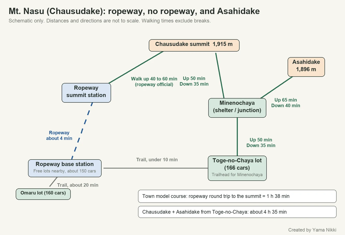
| Climb Chausudake without the ropeway | Toge-no-Chaya via Minenochaya | About 2 h 50 min (50 + 50 min up, 35 + 35 min down) | Toge-no-Chaya parking lot |
| Add Asahidake (1,896 m) | Toge-no-Chaya to Asahidake and back | 3 h 10 min (Nasu Town model course) | Toge-no-Chaya parking lot |
| Do both peaks in one day | Toge-no-Chaya, Chausudake and Asahidake | About 4 h 35 min (sum of section times) | Toge-no-Chaya parking lot |
All times are walking only. Nasu Town says its estimates are based on the average healthy adult man, so allow extra time for breaks and photos.
Getting there from Tokyo
Nasu Town's English course map gives these figures:
- Train: Tohoku Shinkansen (Nasuno or Yamabiko) from Tokyo to Nasushiobara, about 75 minutes. From Nasushiobara or Kuroiso station, take a local bus or taxi to Nasu Yumoto and the mountain.
- Car: From central Tokyo to Nasu IC, about 2 hours via the Tohoku Expressway.
- Highway bus: Shinjuku to Nasu Yumoto, about 4 hours.
Using the Nasu Ropeway
The ropeway connects the base station and the summit station in about 4 minutes. From the summit station, the ropeway's own climbing guide gives 40 to 60 minutes up and 30 to 45 minutes down to the summit, or about 2 to 2.5 hours in total with rests and photos.
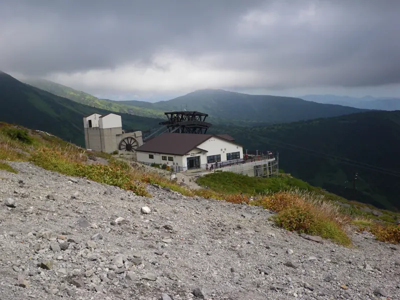

2026 operating details
| Item | Details |
|---|---|
| Season | March 20 to December 13, 2026 (may change for maintenance) |
| Hours | 8:30 to 16:30. Last ride up 16:00, last ride down 16:20 |
| Frequency | Every 20 minutes, at :00, :20 and :40 past the hour |
| Adult (junior high school age and over) | 2,000 yen round trip, 1,500 yen one way |
| Child (age 3 to elementary school) | 1,000 yen round trip, 750 yen one way |
| Pets | 1,000 yen per animal |
The ropeway may stop in bad weather. Because the last ride down is 16:20, a 2 to 2.5 hour round trip means you should start walking from the summit station by about 14:00 at the latest. If the ropeway stops for wind, you will have to walk down.
Climbing without the ropeway
Start from the Toge-no-Chaya parking lot (峠の茶屋駐車場). Nasu Town gives these section times:
| Section | Up | Down |
|---|---|---|
| Toge-no-Chaya lot and Minenochaya shelter (1.4 km) | 50 min | 35 min |
| Minenochaya shelter and Chausudake | 50 min | 35 min |
That is about 1 hour 40 minutes up and 1 hour 10 minutes down. According to the ropeway, the trail from the Toge-no-Chaya lot to the ropeway base station takes under 10 minutes, so you can also walk up and ride down. In that case plan around the one-way fare and the 16:20 last ride.
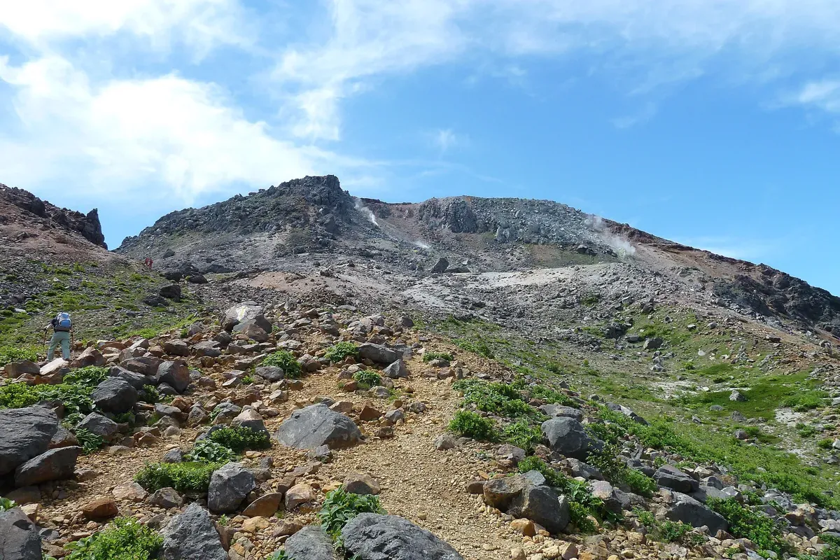

Adding Asahidake
Minenochaya is the junction. Nasu Town's Asahidake model course is a 4.6 km, 3 hour 10 minute round trip from the Toge-no-Chaya lot:
| Section | Time |
|---|---|
| Toge-no-Chaya lot to Minenochaya | 50 min |
| Minenochaya to Asahidake | 65 min |
| Asahidake to Minenochaya | 40 min |
| Minenochaya to Toge-no-Chaya lot | 35 min |
Adding Chausudake (50 minutes up, 35 minutes down from Minenochaya) brings the day to about 4 hours 35 minutes of walking. The ropeway's guide says wind can be strong on Chausudake, so first-timers may prefer the ropeway round trip to Chausudake and keep Asahidake for another visit.
Autumn color and the Ubagadaira walk
The model course to Ubagadaira (姥ヶ平) starts at the ropeway summit station, goes via Ushigakubi to Ubagadaira, and returns the same way. It is 3.2 km and 2 h 13 min including the ropeway: 30 min to Ushigakubi, 25 min on to Ubagadaira, then 40 min back to Ushigakubi and 30 min to the station.
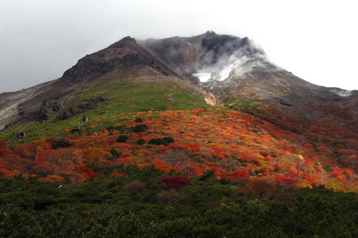

Color changes from day to day. For current conditions, check the Weathernews foliage page for Mt. Nasu (Japanese), which is provided by the Nasu Town Tourism Association.
Parking and autumn traffic in 2026
Nasu Town warns that Mt. Nasu and the area around Nasu IC suffer heavy traffic on weekends and holidays in the autumn color season (late September to late October). The Toge-no-Chaya lot is very crowded from early morning on fine days, so the town suggests the Omaru lot if you plan a long stay.
| Parking | Spaces | Notes |
|---|---|---|
| Lots near the ropeway base station (3 lots) | About 150 cars, free | Locked at set times on summer holiday weekends and autumn weekends and holidays to control traffic (Nasu Ropeway) |
| Toge-no-Chaya lot | 166 | Trailhead for Minenochaya and Asahidake. Under 10 minutes by trail to the ropeway base station |
| Omaru lot (prefectural) | 160 | About 20 minutes on foot to the ropeway base station |
Tochigi Prefecture says that traffic cones will be placed along the road shoulder between the Omaru lot and the Toge-no-Chaya lot to stop roadside parking, from September 26 to October 25, 2026 (planned). For the latest congestion measures and detour maps, see the Tochigi Prefecture page (Japanese) and its map PDFs. The prefecture also recommends taking detours and using the bus.
Bus from Nasushiobara and Kuroiso
Kanto Bus runs the Nasu line from JR Nasushiobara and Kuroiso stations toward Nasu Yumoto Onsen and the ropeway. In the timetable search on October 9, 2026, the buses from the ropeway toward Kuroiso and Nasushiobara left at 13 minutes past each hour from 9:13 to 15:13, with the last at 16:33. The last ride down the ropeway is 16:20, only a few minutes before the last bus, so a late descent can mean missing it. The summer timetable is valid until November 30. I could not re-check the timetable on October 10, so confirm it on the Kanto Bus timetable search (Japanese).
Safety on the mountain
- Wind: the ropeway warns that Chausudake has many wind channels and can become very windy. Turn back if the wind picks up.
- Active volcano: the Japan Meteorological Agency lists Mt. Nasu at Eruption Alert Level 1 ("active volcano, be aware"), with fumaroles and volcanic gas inside the crater area and a warning to be careful there. Check the JMA page (Japanese) before you go.
- No toilets or water: the ropeway says there is no water or toilet above 1,500 m, and the town's map says there are no toilets along the trails. Use the toilets at the lots or the base station first.
- Bears: the town's map says this is bear habitat and asks hikers to carry a bear bell or radio. See our bear safety guide.
- Climbing plan: the town asks hikers to file one on the Compass site (see Japan hiking basics).
- Late autumn: the ropeway runs until December 13, but frost and ice can appear on the trails in November. Plan to finish well before sunset.
The ropeway suggests sturdy walking shoes, a backpack that leaves both hands free, rain gear and warm clothing, drinking water, and a mobile phone. The town's map adds a headlamp, a map, emergency food, and a bear bell.
FAQ
Can I climb Chausudake without the ropeway? Yes. Start at the Toge-no-Chaya lot and walk via Minenochaya. The official section times add up to about 1 hour 40 minutes up and 1 hour 10 minutes down.
How long does it take with the ropeway? The ropeway takes about 4 minutes. From the summit station to the summit, the ropeway's guide says 40 to 60 minutes up, 30 to 45 minutes down, and about 2 to 2.5 hours in total with rests.
Can I do Chausudake and Asahidake in one day? About 4 hours 35 minutes of walking from the Toge-no-Chaya lot, based on the town's section times. Minenochaya is the junction, and you return to it between the two peaks.
Where can I get the course map? Nasu Town publishes a bilingual (Japanese and English) trekking course map as a PDF, with model courses, section times, parking and mobile coverage points.
Summary
- For a first visit, the ropeway round trip to Chausudake is the shortest option: 1 h 38 min in the town's model course.
- Without the ropeway, walk from Toge-no-Chaya via Minenochaya, about 2 h 50 min.
- Asahidake branches off at Minenochaya. With Chausudake, the day is about 4 h 35 min.
- On autumn weekends, arrive early or use the Omaru lot or the bus.
- Check the wind, the volcano status, the ropeway hours and the last bus before you go.
References
- Nasu Ropeway: Information (season, hours, fares) (Japanese)
- Nasu Ropeway: Access and parking (Japanese)
- Nasu Ropeway: For hikers (Japanese)
- Nasu Town: Trekking and hiking course map (PDF, Japanese and English)
- Nasu Town: Hiking guide (Japanese)
- Nasu Town: Avoid traffic jams and enjoy Nasu's autumn color (Japanese)
- Tochigi Prefecture: Autumn traffic measures in the Nasu Highlands, 2026 (Japanese)
- Japan Meteorological Agency: Mt. Nasu volcanic activity (Japanese)
- Kanto Bus: Timetable search for the Nasu Ropeway (Japanese)
- Weathernews: Mt. Nasu foliage (Nasu Town Tourism Association) (Japanese)
Pages marked Japanese are the official sources. Last checked October 10, 2026.
Related articles
- Japan Hiking Basics for Visitors: Climbing Plans, Emergency Numbers, Rescue Costs, Toilets and Trash
- Bear Safety for Hikers in Japan: Season, Where to Check Sightings, Bells, Spray, and What to Do If You Meet One
- Mt. Takao Day Trip from Tokyo: Getting There from Shinjuku, Cable Car Prices, Trails, and the 2026 Autumn Rules
- Kusatsu-Shirane's Yugama Crater Lake Reopens October 13, 2026: Hours, Free Parking, Rules, and What to Expect