
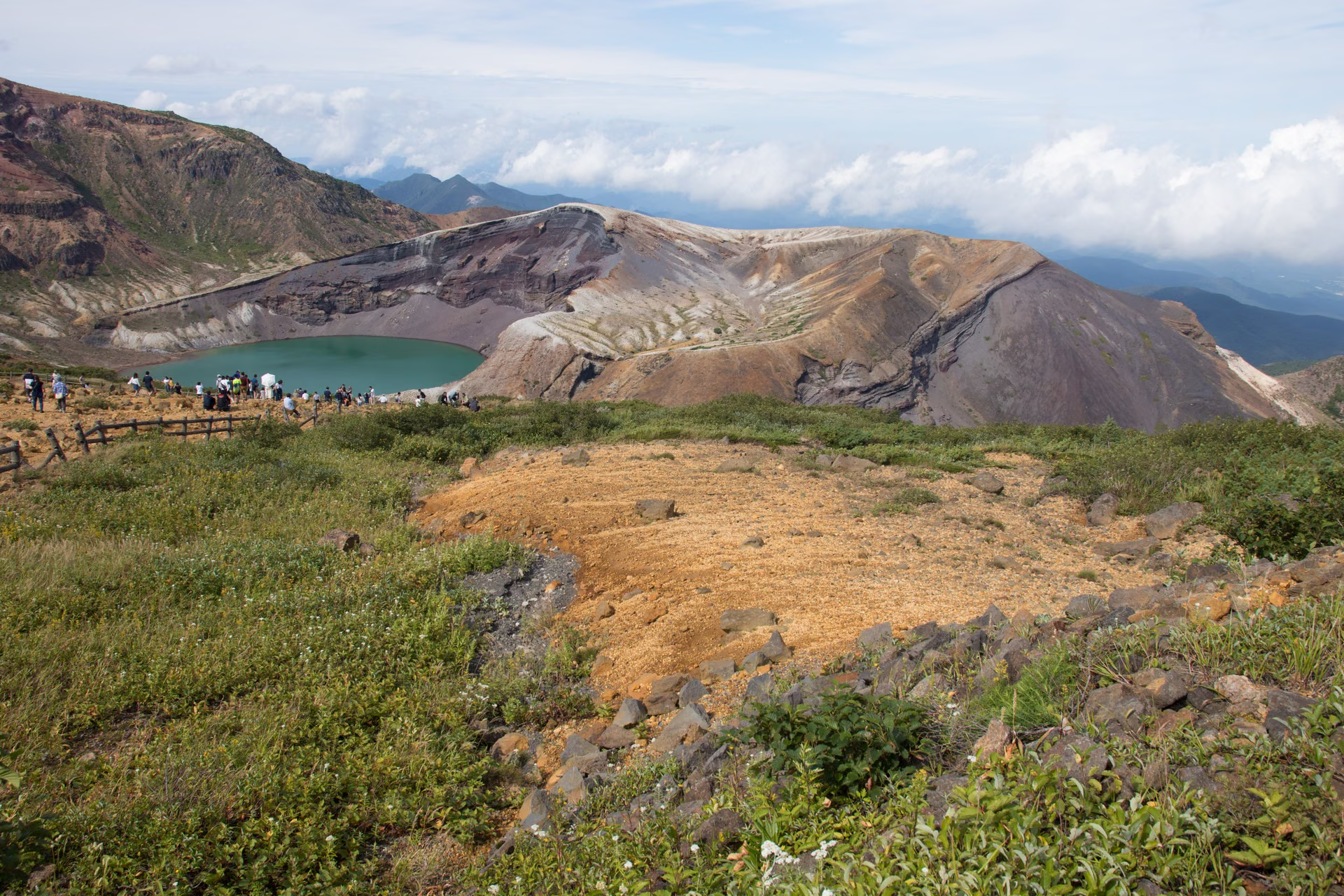
Photo: Σ64, Wikimedia Commons (CC BY 4.0) — Okama Crater Lake, Zao Mountains (August 2018)

Mt. Zao Hiking Guide: Okama Crater Lake, Kumanodake Ridge, Ropeway & Echo Line Closure (2026)
Complete hiking guide to Mt. Zao (Kumanodake, 1,841 m) on the Miyagi-Yamagata border. Compare Okama crater viewing via the Zao Highline and Katta Lift, the Jizodake-Kumanodake-Kattadake ridge trail, Zao Ropeway fares, and 2026 Zao Echo Line closure dates.
Information checked October 24, 2026 against official notices from Yamagata Mountain Portal (Yamagata-yama), Zao Ropeway, Zao Liza World (Katta Lift), Miyagi Kotsu, the Zao Town Tourism and Products Association, the Japan Meteorological Agency (JMA), and the Geospatial Information Authority of Japan (GSI).
Planning Depends on Whether You Visit Okama Only or Hike the Main Ridge
Zao is the collective name for a volcanic mountain range straddling Miyagi and Yamagata Prefectures. For the 100 Famous Japanese Mountains (Nihon Hyakumeizan), the highest peak of Mt. Zao listed by the Geospatial Information Authority of Japan (GSI) is Mt. Kumanodake (1,841 m), while Mt. Kattadake stands at 1,758 m. The emerald-green crater lake Okama (Goshikinuma) is the symbol of the range, where sightseeing and mountain hiking overlap.
Here are the main ways to plan your visit:
- Sightseeing at Okama only: Drive up the Zao Highline toll road to the summit parking lot and walk a few minutes to the viewing area, or take the Katta Lift from Katta Pass along the Zao Echo Line (about 7 minutes on the lift plus a 4-minute walk).
- Hiking the Hyakumeizan ridge: Walk the central ridge linking Mt. Jizodake – Mt. Kumanodake – Mt. Kattadake. Yamagata Prefecture's official mountain portal (Yamagata-yama) rates this traverse at 1 hour 30 minutes to 2 hours one-way, Stamina Level 2, and Technical Difficulty B.
- Starting from Zao Onsen (Yamagata side): Ride the Zao Ropeway up to Jizo Sancho Station (1,661 m) and step directly onto the ridge trail.
- Check road closures first: The Zao Echo Line is scheduled to close for winter at 17:00 on November 4, 2026, with daily nighttime closures in effect from mid-October.
Check the Roads First: Zao Echo Line & Zao Highline Closures
From mid-autumn onward, whether you can drive to the upper trailheads determines your entire plan. Even compared with other Tohoku volcanoes such as Mt. Bandai or Mt. Adatara, each mountain road has its own closing schedule.
According to the Zao Town Tourism and Products Association (updated October 23, 2026) and Miyagi Kotsu, the 2026 operating and closure schedule for the Zao Echo Line and Zao Highline is as follows:
| Road / Regulation | 2026 Schedule | Key Details |
|---|---|---|
| Zao Echo Line: Nighttime Closure | October 13 (evening) – November 4 (morning), 2026 | Closed daily 17:00 – 8:00 the next morning between the Bodaira Kogen Gate (Yamagata side) and Sainokawara Gate (Miyagi side) |
| Zao Echo Line: Winter Closure | November 4, 2026 at 17:00 – April 23, 2027 at 11:00 (scheduled) | Closed between Bodaira Kogen Gate and Sumikawa Gate; no access to Okama or the Katta Pass parking lot |
| Zao Highline (2.5 km toll road) | April 24 – early November 2026 (scheduled) | Regular hours 7:30–17:00; shortened in late autumn (8:00–16:00 per Miyagi Kotsu; Zao Town Tourism notes 8:00–16:30 with last entry at 16:00 through Nov 4). Standard car toll: 600 yen (cash only) |
During winter closure — or during temporary daytime closures caused by snow or icy road surfaces — you cannot reach the Katta Pass parking lot (Katta Lift base) or the Zao Highline summit parking lot. Rime ice (muhyo) was already recorded near the Zao Summit Rest House on October 22, 2026, and Miyagi Kotsu advises snow tires or tire chains from early October through early May.
Sources: Zao Echo Line & Highline Traffic Information (Zao Town Tourism and Products Association), Zao Highline Guide (Miyagi Kotsu)
For more on how late-autumn closures affect mountain transport and huts across Japan, see Late-Autumn Mountain Facility Closures.
Basic Information
| Item | Details |
|---|---|
| Highest Peak | Mt. Kumanodake: 1,841 m (GSI List of Major Mountains in Japan) |
| Mt. Kattadake | 1,758 m (GSI) |
| Location | Miyagi Prefecture (Zao Town, Kawasaki Town, etc.) & Yamagata Prefecture (Yamagata City, Kaminoyama City, etc.) |
| Designation | 100 Famous Japanese Mountains (Nihon Hyakumeizan), Zao Quasi-National Park |
| Classic Ridge Route | Mt. Jizodake – Mt. Kumanodake – Mt. Kattadake (1 hr 30 min – 2 hr one-way, Yamagata-yama) |
| Volcanic Alert Level | Level 1 (Forecast: Be mindful that this is an active volcano — check JMA updates before departure) |


How to View Okama Crater Lake: Zao Highline vs. Katta Lift
Okama is a volcanic crater lake nestled in the Zao range. As the Zao Town Tourism and Products Association notes, entry down to the lakeshore is prohibited; visitors view the crater from the designated upper observation areas.
Option 1: Zao Highline to the Summit Parking Lot
Turn off the Zao Echo Line onto the 2.5 km Zao Highline toll road (600 yen for standard cars, cash only; bicycles, pedestrians, and motorcycles 125 cc or under are not permitted) and drive to the Zao Katta Summit Parking Lot in front of the Summit Rest House. From the parking lot, the Okama viewing points are only a few minutes' walk away. On sunny weekends and during autumn foliage season, traffic congestion can build up at the toll gate and parking lot, so allow extra time. Note that Lot 1 is closed from 17:00 on the day before weekends/holidays until 7:30 the next morning for congestion control.
Option 2: Katta Pass to the Zao Katta Lift
Park at the free Katta Pass lot along the Zao Echo Line and ride the Katta Lift operated by Zao Liza World:
| Item | 2026 Official Details |
|---|---|
| Operating Season | From Saturday, April 25, 2026 (closes around early November; check official updates) |
| Operating Hours | 9:00 – 16:00 (9:00 – 16:30 from July 18 to August 30) |
| Last Uphill Boarding | 45 minutes before closing |
| Fares (tax included) | 1,000 yen round-trip / 600 yen one-way (ages 6 and over) |
| Duration | Approx. 7 minutes on the chairlift + approx. 4 minutes on foot to the Okama viewing area |
Sources: Katta Lift (Zao Liza World), Zao Highline (Miyagi Kotsu)
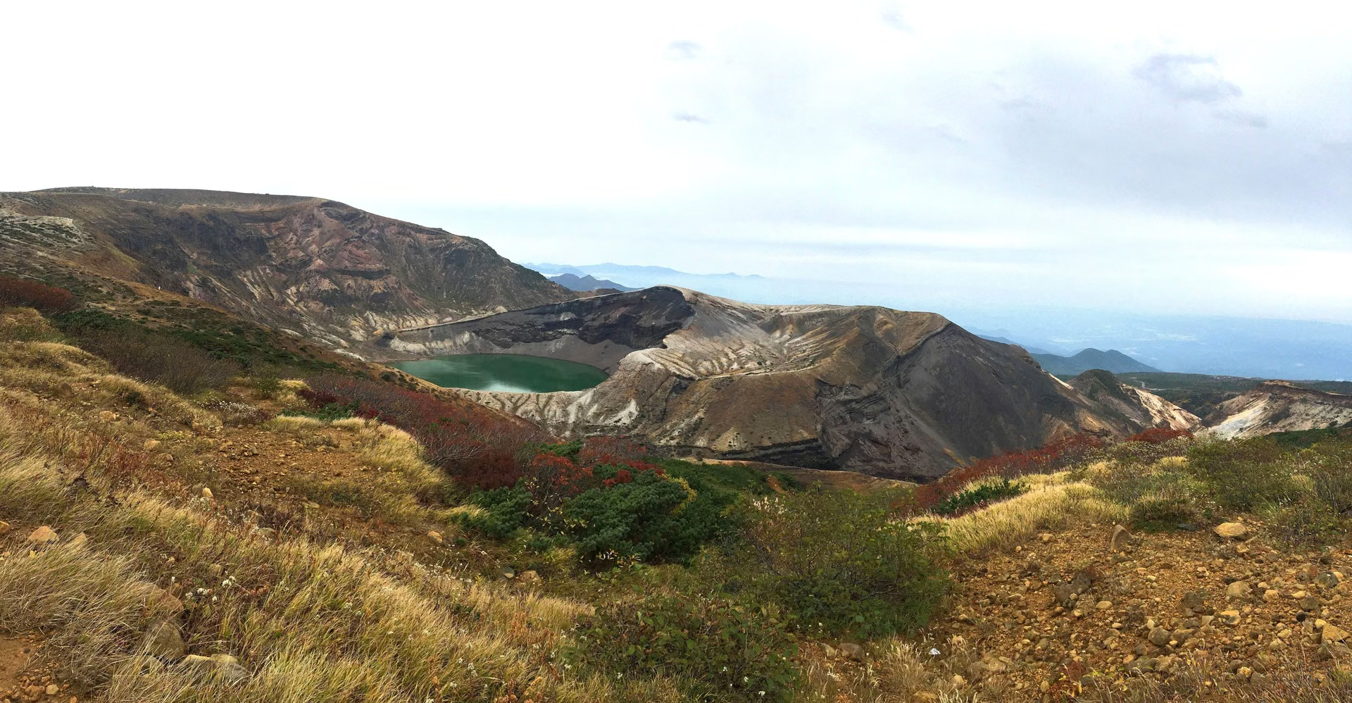

The Hyakumeizan Ridge Route: Jizodake – Kumanodake – Kattadake
Yamagata Prefecture's official mountain portal Yamagata-yama highlights the traverse linking Mt. Jizodake, Mt. Kumanodake, and Mt. Kattadake as the most popular hiking route across Central Zao:
- One-way walking time: 1 hour 30 minutes – 2 hours
- Stamina rating: Level 2
- Technical difficulty: Grade B
- Recommended season: June to October
Because the ridge has relatively gentle elevation changes once you are up high, Yamagata-yama notes that beginners can enjoy trekking here. However, the surface consists of loose volcanic gravel and scree, requiring sturdy footwear, and there is no shade along the ridge, making heatstroke prevention essential in summer and wind protection critical in autumn.
Hikers typically start from one of two bases:
- From the Kattadake / Okama side: Reach the summit area via the Zao Echo Line / Highline or Katta Lift, view Okama, and hike north along the馬の背 (Umanose, "Horse's Back") caldera rim to Mt. Kumanodake (and onward to Mt. Jizodake if desired).
- From the Jizodake / Zao Onsen side: Take the Zao Ropeway from Zao Onsen up to Jizo Sancho Station (1,661 m), climb over Mt. Jizodake (1,736 m) to Mt. Kumanodake (1,841 m), and continue to Mt. Kattadake and Okama.


Source: Mt. Zao — Jizodake & Kumanodake (Yamagata-yama)
Zao Ropeway (Yamagata / Zao Onsen Side)
Located in Zao Onsen (Yamagata City), the Zao Ropeway connects Zao Sanroku Station, Juhyo Kogen Station, and Jizo Sancho Station in two stages:
| Destination | Adult (One-Way / Round-Trip) | Child (One-Way / Round-Trip) |
|---|---|---|
| Jizo Sancho Station (1,661 m) | 2,200 yen / 4,400 yen | 1,100 yen / 2,200 yen |
| Juhyo Kogen Station (1,331 m) | 1,200 yen / 2,200 yen | 600 yen / 1,100 yen |
- Operating hours: Sanroku Line 8:30 – 17:00; Sancho Line 8:45 – 16:45 (subject to change)
- Last uphill boarding for a round trip to Jizo Sancho Station: Departs Zao Sanroku Station at 16:00
- Ride time: Approx. 7 minutes on the Sanroku Line + approx. 10 minutes on the Sancho Line
- Note: Operations may be suspended during strong winds or severe weather
Near Jizo Sancho Station stands the famous Zao Jizo statue, and the station serves as the primary trailhead for Mt. Jizodake, Mt. Kumanodake, and Mt. Kattadake from the Yamagata side. Keep in mind that once snow falls, the upper ridge becomes a full winter mountaineering environment requiring specialized winter gear and navigation skills.
Source: Zao Ropeway Fares & Operating Guide
Volcanic Alert Level & Crater Safety
The Japan Meteorological Agency (JMA) currently designates Mt. Zao at Volcanic Alert Level 1 (Forecast: Be mindful that this is an active volcano). The designated potential crater zone covers the Umanose Caldera, including Mt. Goshikidake and Okama crater lake.
JMA warns that fumaroles and volcanic gas emissions occur in the Maruyamasawa and Furikosawa valleys inside the Umanose Caldera, and advises hikers to move away from the caldera immediately if they notice any abnormalities. Always check the latest JMA status before setting out.
Source: JMA Volcanic Activity Status — Mt. Zao
Recommended Gear & Seasonal Notes


Even if you only visit the Okama viewpoint, you are above 1,700 m in an exposed volcanic saddle where strong winds drop the perceived temperature rapidly. For hiking the ridge to Mt. Kumanodake, prepare:
- Sturdy hiking footwear: Loose volcanic gravel covers much of the ridge. See How to Choose Hiking Boots.
- Windproof & waterproof outer shell: There is almost no tree cover on the ridge between Jizodake, Kumanodake, and Kattadake.
- Sun protection, water & electrolytes: Yamagata-yama specifically notes the lack of shade in summer.
- Warm layers & traction in autumn: In October, freezing winds and rime ice occur on the ridge. See Frozen Autumn Trails & Chain Spikes.
- Headlamp & map app: Essential in case fog rolls in or you are racing ropeway/lift closing times. See Planning Around Autumn Sunset & Headlamps.
- Bear precautions: Forested approaches in Tohoku inhabit Asian black bears. See Bear Bells for Hiking in Japan.
Access
By Car
- From the Miyagi side: Take the Tohoku Expressway to Murata IC or Shiroishi IC, then follow signs toward the Zao Echo Line entrance (Otorii gate; approx. 25 minutes from either interchange according to the Zao Town Tourism and Products Association).
- From the Yamagata side: Drive via Kaminoyama City / Zao Bodaira toward the Yamagata-side Echo Line gate near Zao Liza World, or head to Zao Onsen (229-3 Zao Onsen, Yamagata City) for the Zao Ropeway.
By Public Transport
- Miyagi side bus (Shiroishi-Zao Station – Zao Katta Summit): Miyagi Kotsu (Miyakoh Bus) operates a seasonal bus on weekends and public holidays from April 25 to early November 2026.
- Outbound: Departs JR Shiroishi-Zao Station at 9:38 -> Shiroishi Station 9:46 -> Togatta Onsen 10:23 -> Katta Pass 11:08 -> arrives Zao Katta Summit at 11:11
- Return: Departs Zao Katta Summit at 13:00 -> Katta Pass 13:05 -> arrives JR Shiroishi-Zao Station at 14:35
- Fare: 2,100 yen one-way between Shiroishi-Zao Station and Zao Katta Summit (IC transit cards such as Suica, PASMO, and icsca are accepted; service may be suspended due to road conditions).
References
- Mt. Zao — Jizodake & Kumanodake (Yamagata-yama)
- Zao Ropeway Fares & Operating Guide
- Katta Lift (Zao Liza World)
- Zao Highline & Summit Bus Guide (Miyagi Kotsu)
- Zao Echo Line & Highline Traffic Information (Zao Town Tourism and Products Association)
- JMA Volcanic Activity Status — Mt. Zao
- Geospatial Information Authority of Japan (GSI) — Major Mountains of Japan