

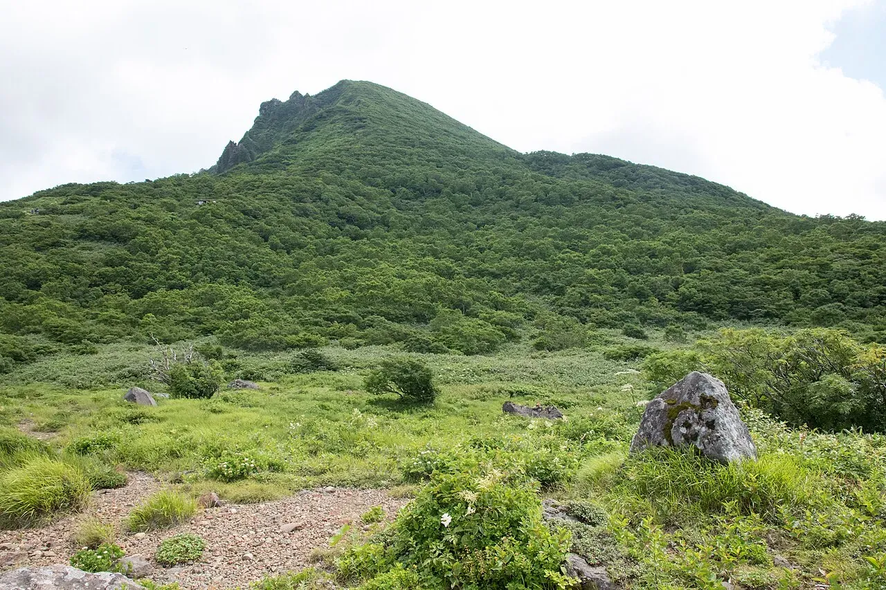
Photo: Σ64, Wikimedia Commons (CC BY 3.0). Mt. Bandai seen from the Inawashiro side, November 2015.

Mt. Bandai Hiking Guide: Choosing from Six Trailheads, the Summer Lift, Parking, and Volcano Status in 2026
How to choose a trailhead for Mt. Bandai (1,816 m) in Fukushima. Compares the six trailheads by standard time, parking and public transport, explains the Happodai and Inawashiro routes, the 2026 summer lift, portable toilets, the volcano alert level, and the winter closure of the Bandai Gold Line, based on Fukushima Prefecture, local tourism offices and the Japan Meteorological Agency.
This guide is based on pages from Fukushima Prefecture, the Urabandai Visitor Center, the Inawashiro ski resort and the Japan Meteorological Agency (JMA) (information as of October 2026). Lift operation, road closures and volcano information change, so check the official pages before you go.
Mt. Bandai (磐梯山, Bandai-san, 1,816 m) is an active volcano in Fukushima Prefecture and one of Japan's "100 Famous Mountains". It is also called Aizu-Fuji. Unlike many peaks, it has six different trailheads, and your choice decides the time, the parking and the scenery. That choice is the main planning task.
The short answer
- Easiest to reach by car, shortest day hike: Happodai. About 2 h 15 min up and 1 h 40 min down. The Urabandai Visitor Center calls it the easiest and most popular route.
- Biggest parking lot, a summer lift, and a hot spring afterward: Inawashiro (at the Inawashiro ski resort). About 2 h up with the lift, 3 h 30 min without it.
- Close to the crater wall: Urabandai. About 3 h 50 min up.
- Without a car: possible for some trailheads, but Happodai and Okinajima have no bus at all.
Basic facts
| Item | Details |
|---|---|
| Height | 1,816 m. The mountain has three peaks: Bandai (1,816 m), Akahaniyama (1,430 m) and Kushigamine (1,636 m) |
| Location | Inawashiro Town, Bandai Town and Kitashiobara Village, Fukushima |
| Designation | One of the 100 Famous Mountains. Bandai-Asahi National Park (includes a special protection zone) |
| Best season | Late May to late October (Urabandai Tourism Association). The mountain opens in late May |
| Volcano alert level | Level 1, "active volcano, be aware" (JMA, checked October 10, 2026) |
The south side of the mountain is called Omote-Bandai and the north side is Ura-Bandai.
Trailheads, times and parking
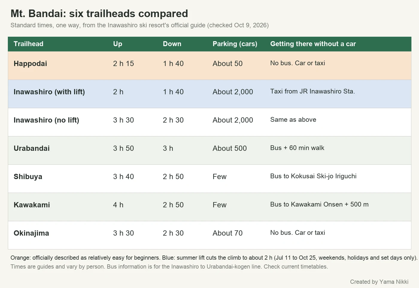
These are the standard times from the Inawashiro ski resort's guide. They are guides only and vary by person.
| Trailhead | Up | Down | Parking and access |
|---|---|---|---|
| Happodai | About 2 h 15 min | About 1 h 40 min | About 50 cars, often full. No bus. Car or taxi |
| Inawashiro, with lift | About 2 h | About 1 h 40 min | About 2,000 cars. Taxi from JR Inawashiro Station about 1,500 yen (3.5 km) |
| Inawashiro, no lift | About 3 h 30 min | About 2 h 30 min | Same as above |
| Urabandai (via Nakanoyu) | About 3 h 50 min | About 3 h | About 500 cars at the Urabandai ski area. Bus, then 60 min walk |
| Shibuya | About 3 h 40 min | About 2 h 50 min | Few spaces. Bus stop "Kokusai Ski-jo Iriguchi" |
| Kawakami | About 4 h | About 2 h 50 min | Few spaces. Bus stop "Kawakami Onsen", then about 500 m |
| Okinajima | About 3 h 30 min | About 2 h 30 min | About 70 cars. No bus |
Happodai: the usual day-hike route
The Urabandai Visitor Center describes the Happodai route as about 3.5 km one way, about 2 h 10 min to the top, and "the easiest and most popular course" on the mountain. The ski resort says it is relatively easy for beginners, and also that it has little variety in scenery. Note that the visitor center rates its difficulty "advanced", and the final section above Kobo-shimizu is steep. Do not treat it as a casual stroll.
- Happodai lot to Nakanoyu-ato: a beech forest that was not affected by the eruption.
- Nakanoyu-ato to Kobo-shimizu: a ridge walk with views of the Urabandai lakes and Mt. Nishi-Azuma, with wildflowers below Kobo-shimizu.
- Kobo-shimizu to the summit: steep. The visitor center suggests taking a break at Kobo-shimizu first.

Parking at Happodai
The Happodai lot is on the Bandai Gold Line and has toilets. Fukushima Prefecture asks drivers not to park on the road. If the lot is full, use the nearby Happodai No. 2 lot or the Koganedaira lot. The Urabandai Tourism Association says roadside parking has caused accidents.
Inawashiro: lift, wetland and hot spring
The Inawashiro trailhead is at the Inawashiro ski resort. It is the only route that passes Numanotaira, a wetland surrounded by the three peaks, and the only one with a day-use hot spring (Villa Inawashiro) at the trailhead. Parking is about 2,000 cars.
Summer lift, 2026
- Dates: July 11 to October 25, 2026, on weekends, holidays and set days only. Daily from July 18 to August 31.
- Effect: about 20 minutes to 1,100 m, then about 2 hours to the summit. Riders can use the lift on the way down too.
- Hours: Base No. 1 quad 7:30 to 15:00 (last ride up 14:30). Sky No. 6 pair 7:30 to 14:40 (last ride up 14:10). Hours may change in bad weather.
- Fares (one way, adult): 800 yen for one lift, or 1,600 yen to ride both. Elementary school children pay 600 yen and 1,200 yen (tax included).
- Hot spring: Villa Inawashiro, adults 1,000 yen, 14:00 to 24:00, last entry 23:30.
After October 25 the lift does not run, so use the no-lift times (about 3 h 30 min up, 2 h 30 min down).

Urabandai, Shibuya, Kawakami and Okinajima
- Urabandai: starts at the Urabandai ski area lot and climbs below the crater wall. By public transport, take the bus from JR Inawashiro Station to Urabandai-kogen Station, then walk about 60 minutes to the ski area.
- Shibuya: a dense forest route. Get off at "Kokusai Ski-jo Iriguchi".
- Kawakami: passes through forest to a rough crater. Get off at "Kawakami Onsen"; the trailhead sign is about 500 m on.
- Okinajima: a steep rocky climb for confident hikers. No bus.
Volcano and the 1888 eruption
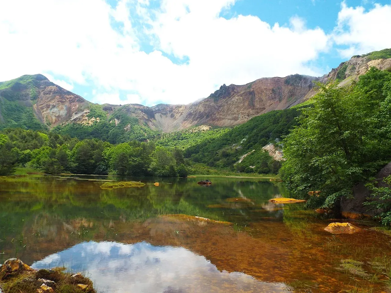
In 1888 a major eruption collapsed the mountain's north side and killed more than 470 people, according to the Bandai Charter quoted on the ski resort's page. The eruption created many lakes, including the Goshikinuma ponds.
JMA lists Mt. Bandai at Level 1 (active volcano, be aware). It notes fumaroles and volcanic gas near the north crater and Numanotaira, and asks visitors to carry a helmet and follow local authority instructions there. Its September 2026 monthly report says volcanic earthquakes have been somewhat frequent since November 2022, with no other notable change and no sign of an eruption.
Fukushima Prefecture asks hikers to:
- not approach or stop at places with volcanic gas warning signs,
- leave quickly if a warning siren sounds, after checking that it is safe,
- not lean on or step beyond the ropes on steep sections.
Toilets and huts
- There are no toilets on the trail or at the summit. Bring a portable toilet. Prefecture guidance puts a portable-toilet booth at Kobo-shimizu.
- The Urabandai Tourism Association says portable toilets are sold at the shops of the Kobo-shimizu hut and the Okabe hut. Disposal boxes are at the Inawashiro and Happodai trailheads and at the Urabandai ski area lot (Urabandai Tourism Association).
- I could not find official opening dates for the two huts, so do not rely on them for food or water.
- Mobile phone coverage is poor in places, such as between the Happodai trailhead and Kobo-shimizu and parts of Numanotaira.
What to bring
The prefecture and the ski resort advise not hiking in light clothing and carrying a map and compass. Bring sturdy boots, rain gear, a headlamp, a bear bell (the ski resort asks hikers to carry one), a portable toilet and warm clothing, since the summit is at 1,816 m. Fukushima Prefecture also asks hikers not to bring pets and not to camp. See our bear safety guide and Japan hiking basics.
Winter road closure: the Bandai Gold Line
Happodai is reached by the Bandai Gold Line, a toll-free scenic road that closes in winter. Fukushima Prefecture's usual pattern is:
- Night closures: late October to mid-November, and late April to early May.
- Full-day closures: mid-November to late April.
- Dates change with the weather. Contact the Inawashiro Civil Engineering Office, +81-242-62-3102 (Japanese).
The Urabandai Visitor Center reported that last winter's full closure ran from 17:00 on November 14, 2025 to 10:00 on April 21, 2026. I could not find an official 2026 start date for the autumn closure, so check before driving up in late October or later.
Getting there
- By car (Inawashiro): Tohoku Expressway to Inawashiro-Bandaikogen IC, or Route 115 and Prefectural Route 7, then to the Inawashiro ski resort. For car navigation, enter "Inawashiro Ski Resort" or the address 7105 Hayama, Inawashiro, Fukushima.
- Without a car: to Happodai, a taxi from JR Inawashiro Station is about 8,000 yen (26.5 km), and from JR Bandai-machi Station about 4,500 yen (15 km), according to the ski resort. There is no bus to Happodai. On the Urabandai side, the Aizu Bus from Inawashiro Station to Urabandai-kogen Station stops near the other trailheads. Taxi fares are estimates.
FAQ
Is Mt. Bandai suitable for beginners? The ski resort calls Happodai relatively easy for beginners, but the visitor center rates it advanced and the top section is steep. Expect about 4 hours of walking, not counting breaks.
Can I get there by public transport only? Not to Happodai or Okinajima. A day hike by car is the realistic option.
What else is nearby? Nekoma-dake (1,404 m), reached from the same Happodai trailhead, is about 1 h 50 min on foot according to the Urabandai Tourism Association.
References
- Inawashiro ski resort: Mt. Bandai trailheads, times and summer lift (Japanese)
- Urabandai Visitor Center: Course No. 20, Mt. Bandai (Happodai) (Japanese)
- Urabandai Tourism Association: Hiking (Japanese)
- Fukushima Prefecture: Climbing Mt. Bandai (Japanese)
- Fukushima Prefecture: Bandai Gold Line and other scenic roads (winter closures) (Japanese)
- Urabandai Visitor Center: Scenic road information (Japanese)
- JMA: Mt. Bandai volcanic activity (Japanese)
- JMA: Monthly volcanic activity report for Mt. Bandai, September 2026 (PDF) (Japanese)
Pages marked Japanese are the official sources. Last checked October 10, 2026.
Related articles
- Japan Hiking Basics for Visitors: Climbing Plans, Emergency Numbers, Rescue Costs, Toilets and Trash
- Bear Safety for Hikers in Japan: Season, Where to Check Sightings, Bells, Spray, and What to Do If You Meet One
- Mt. Nasu (Chausudake) Hiking Guide: With or Without the Ropeway, Asahidake, and Autumn Traffic in 2026
- Kusatsu-Shirane's Yugama Crater Lake Reopens October 13, 2026: Hours, Free Parking, Rules, and What to Expect