
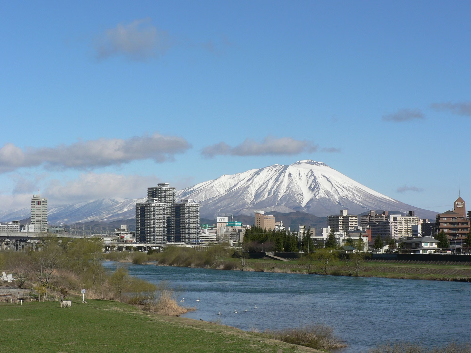
Photo by yisris via Wikimedia Commons (CC BY-SA 2.0)
Mt. Iwate Hiking Guide (2026): Comparing Eastern Trailheads (Umagaeshi & Yakehashiri) & Ongoing Western Trail Closures Under Volcanic Alert Level 1
Complete 2026 hiking guide to Mt. Iwate (2,038 m), Iwate Prefecture's highest peak and one of the 100 Famous Japanese Mountains: comparing the four open eastern routes (Umagaeshi, Yakehashiri, Uwabou, and Onomisaka), ongoing western trail closures even after the August 2026 downgrade to Volcanic Alert Level 1, 8th Station refuge hut dates, and Amihari lift operations.
Current Status in Autumn 2026: Volcanic Alert Level 1, Yet Western Trails Remain Closed
Rising to 2,038 m above the Morioka basin, Mt. Iwate (岩手山) is the highest peak in Iwate Prefecture, one of the 100 Famous Japanese Mountains (日本百名山), and a centerpiece of Towada-Hachimantai National Park (十和田八幡平国立公園). Known locally as "Nanbu Kata-Fuji" (南部片富士, the "One-Sided Fuji of Nanbu") for its sweeping conical profile seen from Morioka, the volcano is served by seven distinct hiking routes documented by the Ministry of the Environment.
Before planning a climb in autumn 2026, every hiker must understand three critical updates:
- Volcanic Alert Level Downgraded to Level 1 (August 27, 2026): At 11:00 JST on August 27, 2026, the Sendai Regional Headquarters of the Japan Meteorological Agency (JMA) lowered Mt. Iwate from Level 2 (Crater Area Restriction) to Level 1 (Potential for Increased Activity).
- Western Trail Closures Remain in Force: Even under Level 1, the Tohoku Regional Forest Office (
東北森林管理局, notice effective October 1, 2026) continues to prohibit entry on western routes around the Nishi-Iwate volcanic zone—specifically Kenmin-no-Mori Trailhead (県民の森登山口, Nanataki Course), Ubakurayama Junction (姥倉山分岐, Matsukawa/Amihari side), and Inukurayama Junction (犬倉山分岐, Amihari Course). - Use the Four Eastern Trailheads (Led by Umagaeshi / Yanagisawa): In autumn 2026, summit climbs are conducted from the eastern side (
馬返しUmagaeshi,焼走りYakehashiri,上坊Uwabou, and御神坂Onomisaka). According to Takizawa City, the caretaker at the 8th Station Emergency Shelter (八合目避難小屋) is stationed from July 1 to October 16, 2026, and the Onimata Shimizu (鬼又清水) spring at the Umagaeshi trailhead is closed for drinking water from October 13, 2026 until further notice due to water-source construction.
All 7 Routes Compared: Which Trailheads Are Open in Autumn 2026?
The table below summarizes the seven official Ministry of the Environment routes on Mt. Iwate and their current entry status as of October 2026:
| Route / Trailhead | One-Way Standard Time & Distance (MOE) | Sector / Character | October 2026 Status |
|---|---|---|---|
Yanagisawa Course (柳沢コース / Umagaeshi 馬返し) |
4 hr 40 min / 7.2 km (Takizawa City lists ~5.7 km: ~4 hr 30 min up / ~3 hr 30 min down) | Southeast (Takizawa City); historic main pilgrimage route | Open (Main Eastern Standard) — Passes the 8th Station Shelter and Onari Shimizu spring |
Yakehashiri Course (焼走りコース) |
5 hr 10 min / 8.5 km | Northeast (Hachimantai City); 1732 lava flow & komakusa alpine slopes | Open (Popular Eastern Route) — Joins Uwabou route below Hirakasafudo Shelter |
Uwabou Course (上坊コース) |
4 hr 00 min / 6.7 km | East (Hachimantai City); quiet forest & 1822 stone milestone pillars | Open (Shortest & Steepest Eastern Route) |
Onomisaka Course (御神坂コース) |
4 hr 40 min / 7.8 km | South slope (Shizukuishi Town); direct, steep pilgrimage ascent | Open (Strenuous Southern/Eastern Route) |
Nanataki Course (七滝コース / Kenmin-no-Mori) |
5 hr 30 min / 8.2 km | West-Northwest (Hachimantai City) | Closed (Entry Prohibited at Kenmin-no-Mori Trailhead) |
Matsukawa Course (松川コース) |
6 hr 30 min / 8.9 km | West (Matsukawa Onsen side) | Closed toward Summit (Ubakurayama Junction Restricted) |
Amihari Course (網張コース) |
5 hr 10 min / 7.3 km (+ 2.3 km lift) | Southwest (Shizukuishi Town / Amihari Onsen) | Closed toward Mt. Iwate Summit (Inukurayama Junction Restricted) — Lift remains open for viewpoints & Mt. Mitsuishi |
Quick Guide to Choosing an Open Eastern Route
- First-time summit climb on Mt. Iwate: Choose Umagaeshi (
馬返し/ Yanagisawa Course), the classic main trail with the 8th Station refuge hut and split old/new trails. - Scenery across a historic lava field: Choose Yakehashiri (
焼走りコース), which skirts the dramatic 1732 Yakehashiri Lava Flow (a Special Natural Monument) before climbing the upper volcanic cone. - Shortest distance & quietest trail (for strong climbers): Choose Uwabou (
上坊コース), rated by the Ministry of the Environment as the shortest and steepest route on the mountain.
Mountain Overview
| Item | Details |
|---|---|
| Summit Elevation | 2,038 m (Yakushidake main peak) |
| Location | Takizawa City, Hachimantai City & Shizukuishi Town, Iwate Prefecture |
| Designations | 100 Famous Japanese Mountains (日本百名山), Towada-Hachimantai National Park, JMA Continuously Monitored Active Volcano |
| Local Nickname | Nanbu Kata-Fuji (南部片富士) |
| Open Summit Trailheads (Autumn 2026) | Umagaeshi (馬返し), Yakehashiri (焼走り), Uwabou (上坊), Onomisaka (御神坂) |
| Main Climbing Season | Official summer climbing season opens July 1; snow-free hiking typically runs through mid-October |

Route 1: Umagaeshi / Yanagisawa Course (馬返し・柳沢コース)
Starting from Umagaeshi (馬返し, elevation 633 m) in Takizawa City, the Yanagisawa Course has served for centuries as the front pilgrimage trail (表参道) to the summit of Mt. Iwate.
Step-by-Step Course Progression
- Umagaeshi Trailhead (633 m): Fill out and drop your climber registration card (
登山者カード) in the trailhead box as requested by Takizawa City. - 2.5th Station Junction (
2.5合目): The trail splits into the rocky, open Old Trail (旧道) and the forested, gentler New Trail (新道). Takizawa City recommends taking the New Trail up to the 4th Station and switching to the Old Trail above that point. - 7th Station (
7合目): The Old and New Trails reunite below the upper cone. - 8th Station Emergency Shelter (
八合目避難小屋) & Onari Shimizu (御成清水): Take a rest at the hut plaza before the final volcanic gravel climb. - Summit Rim (
お鉢/ Yakushidake, 2,038 m): Roughly 1 hour above the 8th Station along the crater rim to the highest point.
Ministry of the Environment Section Time Splits (Yanagisawa Course)
| Section | Ascent Time | Descent Time |
|---|---|---|
| Umagaeshi Trailhead → 2.5th Station Junction | 1 hr 10 min | 50 min |
| 2.5th Station Junction → 7th Station | 2 hr 20 min | 1 hr 40 min |
| 7th Station → Summit Area | 1 hr 10 min | 50 min |
| Total One-Way | 4 hr 40 min | 3 hr 20 min |
8th Station Emergency Shelter (八合目避難小屋) — 2026 Operations
According to Takizawa City's 2026 (Reiwa 8) schedule, the resident caretaker period runs from July 1 to October 16, 2026:
| Facility Item | Official Details (Takizawa City) |
|---|---|
| Capacity | Approx. 100 people |
| Restrooms | Flush toilets available during season |
| Lighting | Fluorescent lighting until 20:00 while caretaker is present; solar-charged LED lighting thereafter |
| Water Source | Outdoor spring Onari Shimizu (御成清水) — subject to drying up in late summer/autumn and shut off in winter to prevent freezing |
| Overnight Cooperation Fee | Adults 2,000 yen / High school (18 & under) 1,500 yen / Junior high (15 & under) 1,000 yen / Elementary (12 & under) free |
| Reservations | Required online for groups of 4 or more; not required for 1–3 hikers |
After October 16, plan on the shelter being unstaffed and carry all water you need from the trailhead in case Onari Shimizu is dry or shut off.
Access to Umagaeshi Trailhead & Water Warning
- By Car: Approx. 15 minutes (~8 km) from Takizawa IC (
滝沢IC) on the Tohoku Expressway. Free trailhead parking and restrooms are available at Umagaeshi. - By Train + Taxi: Approx. 20 minutes (~11 km) by taxi from Takizawa Station (
滝沢駅) on the IGR Iwate Galaxy Railway. (As noted by Takizawa City, there is no regular route bus serving the Umagaeshi trailhead.) - Onimata Shimizu Water Closure (Oct 13, 2026–): The trailhead spring Onimata Shimizu (
鬼又清水) is closed for drinking water from October 13, 2026 until further notice due to water-source work. Bring full water bottles before arriving at the trailhead.
Route 2: Yakehashiri Course (焼走りコース)
Starting beside the Yakehashiri Lava Flow (焼走り熔岩流) in Hachimantai City, the Yakehashiri Course (5 hr 10 min one way / 8.5 km per the Ministry of the Environment) is the second classic eastern trail up Mt. Iwate.
- Highlights: Views over the barren black basalt lava flow erupted in 1732 (Kyoho 16), summer komakusa (
コマクサ, dicentra) colonies on the volcanic gravel slopes, and sweeping eastern Tohoku vistas. - Shelter along the route: After merging with the Uwabou Course, the trail passes the Hirakasafudo Emergency Shelter (
平笠不動避難小屋), which has a toilet for rest stops but no drinking water source. - Access: Reached by car from Nishine IC (
西根IC) on the Tohoku Expressway.

Routes 3 & 4: Uwabou (上坊) & Onomisaka (御神坂) Courses
- Uwabou Course (
上坊コース, 4 hr 00 min one way / 6.7 km): Begins near Uwabou Shrine. Although much of the lower trail stays inside the forest with limited views, it is the shortest and steepest route to the summit and sees far fewer hikers, passing historic stone milestone pillars erected in 1822 (Bunsei 5) between the 2nd and 8.5th stations. - Onomisaka Course (
御神坂コース, 4 hr 40 min one way / 7.8 km): Climbs almost straight up the southern flank along a steep historic pilgrimage path preserving Edo-period place names such as Zori-nugiba ("straw-sandal removal spot"). A stone emergency shelter sits at the 9th Station (no water source; use the 8th Station shelter on the Yanagisawa side if needed).
Why Western Trails & the Amihari Summit Link Remain Closed
Ongoing Forest Road & Trail Restrictions in Nishi-Iwate
Even though JMA lowered Mt. Iwate's Volcanic Alert Level to Level 1 on August 27, 2026, JMA's advisory notes that sudden emissions of volcanic ash, volcanic gas, or hydrothermal water remain possible inside the assumed Nishi-Iwate crater zone, with elevated geothermal heat and volcanic gas concentrations particularly around Daijigokudani (大地獄谷).
Consequently, the Tohoku Regional Forest Office (notice effective October 1, 2026) maintains entry closures at three western points:
- Kenmin-no-Mori Trailhead (
県民の森登山口, Hachimantai City) — Nanataki Course entrance - Ubakurayama Junction (
姥倉山分岐, Hachimantai City) — Junction linking the Matsukawa and Amihari routes toward Nishi-Iwate - Inukurayama Junction (
犬倉山分岐, Shizukuishi Town) — Junction along the Amihari ridge route
Amihari "Tenku no Lift" (網張温泉「天空のリフト」) in 2026
Because Inukurayama Junction is closed, you cannot use the Amihari Onsen chairlifts to climb to the summit of Mt. Iwate in autumn 2026. However, the lifts at Kyukamura Iwate Amihari Onsen remain open for scenic riding, Inukura Viewpoint (犬倉展望台), and hikes toward Mt. Mitsuishi (三ツ石山):
| Item | 2026 Official Schedule & Fares (Kyukamura Iwate Amihari Onsen) |
|---|---|
| Operating Period | June 1 – November 3, 2026 |
| Lift #1 (to Tenku-no-Oka) | Operates daily in principle (hours vary between weekdays and weekends/holidays) |
| Lifts #1–#3 (to Inukura Viewpoint) | Limited autumn dates (Sept 19–27, Oct 1–4, Oct 10–12, etc.) |
| One-Way Adult Fares | 1 lift: 800 yen / 2 lifts: 1,200 yen / 3 lifts: 1,600 yen (Elementary school children half price) |
| Round-Trip Adult Fares | 1 lift: 1,200 yen / 2 lifts: 1,600 yen / 3 lifts: 2,100 yen |
Summit Crater Rim (お鉢巡り) & 360-Degree Views
At the top of the upper volcanic cone, the trail circles the summit crater rim (お鉢), lined with stone Buddha statues and the inner shrine (奥の院) of Iwatesan Shrine. On a clear day, the 2,038 m summit rewards climbers with a 360-degree panorama stretching from Mt. Iwaki and the Hakkoda Mountains in the north to Mt. Hayachine in the east and Mt. Chokai to the southwest.
Because the crater rim is completely exposed above treeline, winds are strong and visibility drops rapidly in fog. If dense clouds or gale-force winds hit the rim, skip the full crater-rim loop and descend promptly via your ascent route.


Seasonal Safety & Gear Checklist for Mt. Iwate
Takizawa City urges hikers to carry a climbing helmet, headlamp, and cotton towel (手ぬぐい, for covering the mouth/nose in case of volcanic ash or gas) in addition to standard alpine gear:
- Helmet & headlamp (recommended by Takizawa City for rockfall and volcanic preparedness)
- Full rainwear (jacket + pants), warm fleece/down mid-layer, windproof gloves, and knit cap (layering guide and autumn hypothermia prevention)
- Extra drinking water & high-energy snacks (with Onimata Shimizu under construction from Oct 13 and Onari Shimizu prone to drying up or winter shutoff)
- Rubber tip caps on trekking poles (requested by Takizawa City to protect alpine vegetation and trail surfaces)
- Bear bell and bear deterrent spray for the lower forest approaches
References
- Takizawa City Official — Mt. Iwate Climbing Information, 8th Station Shelter & Onimata Shimizu Notice (
岩手山|滝沢市) - Ministry of the Environment (Towada-Hachimantai National Park) — The 7 Climbing Trails of Mt. Iwate (
岩手山7つの登山道) - Ministry of the Environment — Yanagisawa Course (Umagaeshi)
- Ministry of the Environment — Yakehashiri Course
- Ministry of the Environment — Uwabou Course
- Ministry of the Environment — Onomisaka Course
- Ministry of the Environment — Amihari Course
- Tohoku Regional Forest Office — Entry Restrictions on Mt. Iwate (
岩手山への入山規制について, Oct 1, 2026 update) - Japan Meteorological Agency — Volcanic Activity Status of Mt. Iwate (
火山活動の状況) - Iwate Prefecture — Trailhead Signage Following Partial Lifting of Mt. Iwate Restrictions
- Kyukamura Iwate Amihari Onsen — Tenku no Lift 2026 Schedule & Fares
- Iwate Prefecture Event Guide — Amihari Onsen Tenku no Lift Operations