

Photo: 雷太, Wikimedia Commons (CC BY 2.0) / Upper rocky slopes and autumn grasses on Mt. Iwaki in October

Mt. Iwaki Hiking Guide: Tsugaru Iwaki Skyline & Chairlift from the 8th Station, Dake and Hyakuzawa Trails, and Autumn Closures
Complete hiking guide to Mt. Iwaki (1,625 m), Aomori Prefecture's highest peak and one of Japan's 100 Famous Mountains. Covers the Tsugaru Iwaki Skyline toll road and chairlift route (40 minutes from the 9th Station), full climbs via the Dake Onsen and Hyakuzawa trails, the 13:00 departure cutoff, 2026 autumn closure dates, and Yayoi Trail bear closures.
Key Takeaway: Driving to the 8th Station vs. Climbing from the Base Are Two Completely Different Hikes
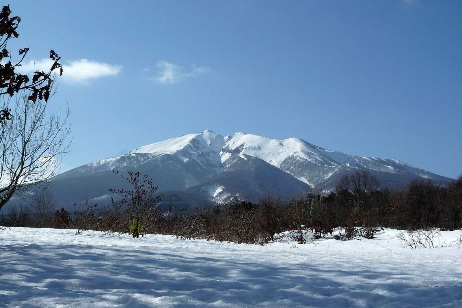
Rising as a sweeping, isolated volcanic cone above the Tsugaru Plain, Mt. Iwaki (Iwaki-san) is introduced by Aomori Prefecture's official tourism site (Amazing AOMORI) as the highest mountain in Aomori Prefecture. Listed among the 100 Famous Japanese Mountains (Nihon Hyakumeizan) and affectionately called O-Iwaki-san or Tsugaru Fuji, its summit elevation is 1,625 m on the official Mt. Iwaki Climbing Map (PDF) published by the Mt. Iwaki Tourism Association (1,624 m triangulation point in the JMA Volcano Catalog PDF).
What makes Mt. Iwaki unique is that a paved toll road (Tsugaru Iwaki Skyline) climbs all the way to the 8th Station, and a chairlift carries hikers from the 8th Station to the 9th Station:
- Short Summit Climb: Drive or take the shuttle bus up the Tsugaru Iwaki Skyline to the 8th Station → Ride the chairlift (~10 min) to the 9th Station → Hike approx. 40 minutes one-way up the rocky trail to the summit.
- Full Base-to-Summit Climb: Hike from Dake Onsen via the Dake Course (~4 hours one-way) or from Iwakiyama Shrine via the Hyakuzawa Course (~5 hours one-way).
- Up by Chairlift, Down on Foot: Recommended by Amazing AOMORI, but only possible if you ride the shuttle bus to the 8th Station—you cannot leave a private car parked at the 8th Station past 16:30.
On a clear day, the summit panorama takes in Mt. Hakkoda, Gongenzaki and Lake Jusan on the Tsugaru Peninsula, Shichiri Nagahama Beach, and even Cape Matsumae in Hokkaido (Amazing AOMORI).
Essential Late-Autumn 2026 Notices
Before heading to Mt. Iwaki in late October or November, check these five official operational rules:
- Tsugaru Iwaki Skyline closes after November 15, 2026 (Sun): Scheduled operating dates are April 23 to November 15, 2026, subject to early closure or full-day suspension whenever snow falls (in 2025, an early snowfall on October 20 closed both the toll road and chairlift for the entire day; see Tsugaru Iwaki Skyline Operating Info and Mt. Iwaki Tourism Association Snow Closure Notice).
- Iwaki-san Chairlift runs until "early November" (Closed Oct 27 & 28, 2026): The lift is scheduled to close in early November depending on snowfall, and is closed on Tuesday, October 27 and Wednesday, October 28, 2026 (Tsugaru Iwaki Skyline Operating Info).
- Dake Onsen–8th Station Shuttle Bus ends October 31, 2026: In November, there is no public bus access to the 8th Station.
- No Summit Departures from the 8th Station After 13:00: The Skyline operator explicitly asks hikers to refrain from starting up from the 8th Station after 1:00 PM.
- Yayoi Trail Closed Since September 1, 2025 Due to Bear Activity: Both the new and old Yayoi trails remain closed until further notice (Mt. Iwaki Tourism Association Trail Info).
Comparing the 5 Hiking Trails and the Skyline + Chairlift Route
All walking times published by the Mt. Iwaki Tourism Association are one-way ascent times (not round-trip times):
| Route | Starting Point | One-Way Ascent Time | Official Notes & Characteristics |
|---|---|---|---|
| Skyline + Chairlift | 8th Station (Skyline terminal) → Chairlift to 9th Station | Lift ~10 min + Walk ~40 min | Steep, rocky boulder trail from the 9th Station to the summit |
| Dake Course | Dake Onsen (torii gate above Dake Onsen public parking lot) | ~4 hours | Rated for general hikers; frequently used for school climbs. Watch for rockfall above Homei Hut |
| Hyakuzawa Course | Iwakiyama Shrine precincts (Hyakuzawa) | ~5 hours | Intermediate-to-advanced main route; snow lingers in Osawa gorge in June–July; watch for rockfall on Omisaka. Detour in effect near shrine until July 25, 2030 |
| Akakura Course | Near Oishi Shrine (Omori, Hirosaki) | ~4 hours 30 min | Historic ascetic route lined with stone Buddhist statues |
| Nagatai Course | Aomori Spring Ski Resort (Ajigasawa Town) | ~4 hours 30 min | Western approach from the Ajigasawa side |
| Yayoi Course | Yayoi Ikoi-no-Hiroba | ~5 hours | CLOSED since September 1, 2025 until further notice due to frequent bear sightings |
Because Mt. Iwaki is an isolated coastal peak where weather shifts rapidly, the Mt. Iwaki Tourism Association recommends hiking with a guide or experienced support. For local trail inquiries, contact Iwaki Sanpo-kan (Iwaki Trail Center / Japanese Red Cross Mt. Iwaki Patrol Team, Tel: 0172-83-2093).
Taking the Tsugaru Iwaki Skyline and Chairlift (40 Minutes from 9th Station)
Tsugaru Iwaki Skyline (Toll Road to the 8th Station)
The Tsugaru Iwaki Skyline is a 9.8 km paved mountain toll road with 69 hairpin curves climbing from near Haguro Onsen (past Dake Onsen) to the 8th Station. Because it is a motor-vehicle-only road, pedestrians and bicycles are strictly prohibited, and stopping or parking outside designated pullouts is banned.
| 2026 Tsugaru Iwaki Skyline Schedule | Details |
|---|---|
| Operating Period | April 23 (Thu) – November 15 (Sun), 2026 (subject to snowfall closures) |
| Gate Hours | Open 08:00 – Close 17:00 (last entry 16:00) |
| Round-Trip Toll | Standard / compact cars: 2,000 JPY; Kei (mini) cars: 1,700 JPY; Motorcycles: 1,200 JPY |
A rest house is open at the 8th Station terminal (the shop is closed for the 2026 season).
Mt. Iwaki Chairlift (8th Station to 9th Station)
| 2026 Chairlift Schedule | Details |
|---|---|
| Operating Period | Until early November 2026 (subject to snowfall) |
| Operating Hours | 09:00 – 16:30 (last uphill ride 16:00, last downhill ride 16:20) |
| October Closed Days | Tuesday, October 27 & Wednesday, October 28, 2026 |
| Fares | Adults: 1,500 JPY round trip / 1,200 JPY one way; Jr. High & High School: 800 JPY RT / 600 JPY OW; Elementary: 600 JPY RT / 500 JPY OW |
The chairlift ride takes about 10 minutes to the 9th Station (Tori-no-umi), leaving a 40-minute one-way climb over rocky volcanic terrain to the summit (Tsugaru Iwaki Skyline Operating Info).
The 13:00 Cutoff and the 16:30 Police Report Rule
Two safety rules at the 8th Station are strictly enforced:
- Do not start climbing from the 8th Station after 13:00 (1:00 PM).
- Any vehicle still parked at the 8th Station after 16:30 (4:30 PM) is reported to the police as a missing-hiker search case.
Because the last downhill lift departs at 16:20 and the Skyline gates close at 17:00, starting before 13:00 gives you comfortable margin for the round trip. This 16:30 rule also means you cannot park a car at the 8th Station and hike down to the base via the Dake or Hyakuzawa trails.


Climbing from the Base: Dake Course and Hyakuzawa Course
1. Dake Course (From Dake Onsen, ~4 Hours One Way)
Rated by the Mt. Iwaki Tourism Association as the standard general-hiker trail from the base, the Dake Course starts at the torii gate just above the Dake Onsen Public Parking Lot. According to the Mt. Iwaki Climbing Map (PDF), the trail ascends through beech forest and dwarf bamboo (nemagaridake) slopes to Homei Hut (emergency shelter, 1,490 m) near the 9th Station junction, then climbs the rocky upper cone to the summit. Watch carefully for falling rocks above Homei Hut.
2. Hyakuzawa Course (From Iwakiyama Shrine, ~5 Hours One Way)
Starting from the left side of the Iwakiyama Shrine precincts, the Hyakuzawa Course is Mt. Iwaki's classic intermediate-to-advanced shrine ascent, passing Yakidome Hut (emergency shelter, 1,066 m), the alpine pond Tanemaki Nawashiro, and Homei Hut (1,490 m).
- June–July Snow Gorge Warning: The official climbing map warns that the Osawa snow gorge retains deep, steep snow through June and July, requiring crampons and experienced leadership. Watch for rockfall on the steep Omisaka pitch above Yakidome Hut.
- Construction Detour (Sept 14, 2026 – July 25, 2030): Due to shrine construction work, a section of the Hyakuzawa trail between Iwakiyama Shrine and Sakurabayashi Park is closed from September 14, 2026 through July 25, 2030 (scheduled); follow the signed detour route (Mt. Iwaki Tourism Association Detour Notice).


Access: Driving, Parking, and Konan Bus
By Car and Trailhead Parking
From the Tohoku Expressway Owani-Hirosaki IC, driving via the Apple Road takes roughly 40 minutes to the Skyline entrance, or about 35 minutes from JR Hirosaki Station to Iwakiyama Shrine (Tsugaru Iwaki Skyline Access, Amazing AOMORI).
| Trailhead | Official Parking Guidance (Mt. Iwaki Tourism Association) |
|---|---|
| 8th Station | 8th Station terminal parking lot (Skyline toll required) |
| Dake Course | Dake Onsen Public Parking Lot (Dake Onsen Kyodo Chushajo) |
| Hyakuzawa Course | Iwakiyama Shrine Masugata Parking Lot or Hyakuzawa Parking Lot |
| Akakura Course | Open space near the Oishi Shrine torii gate |
| Nagatai Course | Aomori Spring Ski Resort parking lot |
By Bus and Shuttle Bus
Konan Bus operates the Iwakisan Line from Hirosaki Bus Terminal (via JR Hirosaki Station) to Iwakiyama Jinja-mae (Hyakuzawa trailhead) and Dake Onsen-mae. At Dake Onsen, transfer to the seasonal Iwaki Skyline Shuttle Bus to the 8th Station (Tsugaru Iwaki Skyline Access):
- Hirosaki – Dake Onsen: 500 JPY one way (approx. 1 hour)
- Dake Onsen – 8th Station Shuttle Bus: 1,400 JPY one way (approx. 30 minutes; 2026 operating season: April 23 – October 31, 2026)



Bear Warnings and Volcanic Alert Status
- Yayoi Trail Closure & Aomori Bear Alert: The Yayoi Trail has been closed since September 1, 2025 after repeated bear sightings and claw marks on trail posts (Mt. Iwaki Tourism Association Notice). Aomori Prefecture has also issued a prefecture-wide Asian Black Bear Alert (Tsukinowaguma Shutsubotsu Keiho) through November 30, 2026 (Aomori Prefecture Press Release) and publishes sightings on the Kuma-Log Aomori map. Carry a bear bell and bear spray.
- Volcanic Status (JMA Alert Level 1): Mt. Iwaki is an active volcano currently at Forecast / Alert Level 1 (Be mindful that it is an active volcano) (JMA Mt. Iwaki Activity Info). Even in quiet periods, the JMA advises awareness of potential sudden volcanic gas or ash emissions near crater zones.
Reference Links
- Mt. Iwaki Tourism Association — Climbing Trails Guide
- Mt. Iwaki Environmental Conservation Council — Mt. Iwaki Climbing Map (PDF)
- Mt. Iwaki Tourism Association — Partial Closure & Detour on Hyakuzawa Trail
- Mt. Iwaki Tourism Association — Yayoi Trail Bear Closure Notice
- Mt. Iwaki Tourism Association — Seasonal News
- Tsugaru Iwaki Skyline — Operating Hours, Tolls & Chairlift Schedule
- Tsugaru Iwaki Skyline — Access & Bus Information
- Amazing AOMORI (Official Aomori Tourism Site) — Mt. Iwaki
- Japan Meteorological Agency — Volcanic Activity Status for Mt. Iwaki
- Japan Meteorological Agency — Volcano Catalog: 22. Mt. Iwaki (PDF)
- Aomori Prefecture — Asian Black Bear Alert Announcement
- Kuma-Log Aomori — Aomori Bear Sighting Map