

Photo: kuri20001031, Wikimedia Commons (CC BY 2.0)

Mt. Hakkoda (Hakkoda Odake) Hiking Guide: Sukayu Onsen Loop over Kenashitai Wetlands and the Hakkoda Ropeway Route
Complete guide to hiking Mt. Hakkoda (Hakkoda Odake, 1,585 m) in Aomori Prefecture, one of the 100 Famous Japanese Mountains. Compares the classic Sukayu Onsen–Senningantai–Kenashitai loop and the Hakkoda Ropeway course, with volcanic gas warnings, JR bus access, and seasonal foliage tips.
Rising in the heart of Towada-Hachimantai National Park just south of Aomori City, Mt. Hakkoda (八甲田山) is one of the 100 Famous Japanese Mountains (Nihon Hyakumeizan).
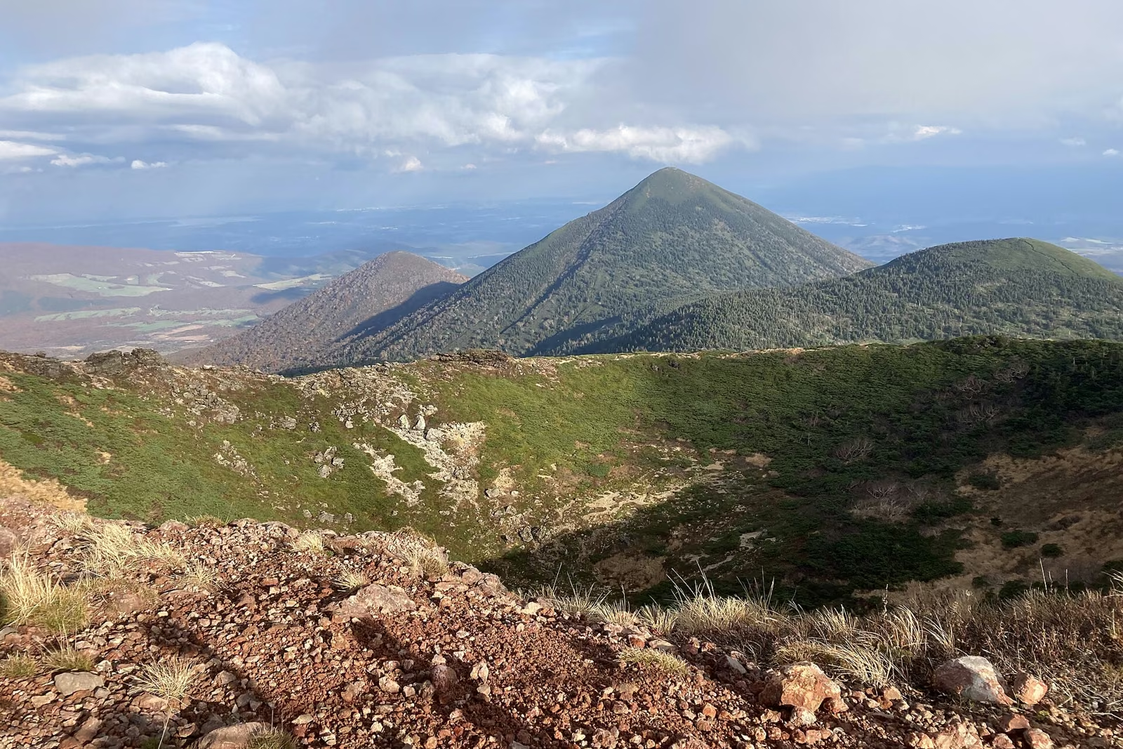
Rather than a single isolated cone, "Mt. Hakkoda" is the collective name for 18 volcanic peaks divided into the Northern Hakkoda (北八甲田) and Southern Hakkoda (南八甲田) groups. The highest peak—and the main summit climbed by hikers—is Hakkoda Odake (八甲田大岳, 1,584.6 m, rounded to 1,585 m) in the Northern Hakkoda group.
What makes Mt. Hakkoda one of northern Japan's signature hikes is the variety packed into a 4.5 to 5-hour loop: steaming volcanic vents above Sukayu Onsen (酸ヶ湯温泉), crater ponds near the 1,585 m summit, wooden boardwalks winding across the sky-high Kenashitai (毛無岱) wetlands, and a historic cedar bathhouse waiting right at the trailhead. You can also combine the hike with the Hakkoda Ropeway (八甲田ロープウェー) starting at 1,324 m.
Overview of Mt. Hakkoda (Hakkoda Odake)
| Item | Details |
|---|---|
| Elevation | 1,585 m (Hakkoda Odake 八甲田大岳, 1,584.6 m; highest peak of the 18 Hakkoda volcanoes) |
| Location | Aomori City & Towada City, Aomori Prefecture (Towada-Hachimantai National Park) |
| Trailhead Elevation | Approx. 900 m (Sukayu Onsen Trailhead) / Approx. 1,324 m (Hakkoda Ropeway Sancho Park Station) |
| Elevation Gain | Approx. 685 m (Sukayu Onsen loop) / Approx. 450 m cumulative (Ropeway → Odake → Sukayu) |
| Standard Walking Time | Approx. 4 hr 30 min – 5 hr (Sukayu Onsen loop) / Approx. 4 hr (Ropeway Sancho Station → Odake → Sukayu Onsen) |
| Distance | Approx. 9.2 km (Sukayu Onsen loop) |
| Difficulty | Beginner to Intermediate |
| Best Hiking Season | Late June to Mid-October (Summer alpine flora: July–August / Peak autumn foliage: late September–mid-October) |
| Restrooms | Sukayu Public Parking Lot (24h during green season), Hakkoda Ropeway Stations, Odake Hinan-goya (大岳避難小屋, emergency shelter toilet at the saddle below the summit) |
| Volcanic Alert Check | Active volcano monitored by the Japan Meteorological Agency (JMA); check volcanic gas warnings before departure |
Highlights of Mt. Hakkoda
1. The Stairway Over Kami- and Shimo-Kenashitai Wetlands
On the eastern flank of Hakkoda Odake stretch the twin alpine marshes of Kami-Kenashitai (上毛無岱) and Shimo-Kenashitai (下毛無岱), connected by a dramatic wooden staircase of roughly 300 steps descending from a cliff-edge viewpoint. In July and August, cotton grass (watasuge) and daylilies (nikko-kisuge) dot the ponds; from late September to early October, the entire wetland basin turns golden orange and crimson (kusamomiji), creating one of Tohoku's most famous autumn vistas.


2. Panoramic Views from the 1,585 m Summit of Hakkoda Odake
From the broad, rocky summit of Hakkoda Odake (1,585 m), clear days reveal a 360-degree panorama across northern Tohoku:
- West: Mt. Iwaki (
岩木山, 1,625 m)—the "Tsugaru Fuji"—rising above the Tsugaru Plain - North: Mutsu Bay (
陸奥湾), Aomori City, the Shimokita and Tsugaru Peninsulas, and on crystal-clear days across the Tsugaru Strait to Hokkaido - South: The undisturbed ridges and marshes of Southern Hakkoda (
南八甲田) and the caldera rim toward Lake Towada (十和田湖) - Below the summit: The circular crater pond Kagamiga-numa (
鏡沼) and the peaks of Idodake (井戸岳) and Akakuradake (赤倉岳)

3. Starting and Finishing at Historic Sukayu Onsen
The main trailhead sits right beside Sukayu Onsen (酸ヶ湯温泉), famous for its Hiba Sennin-buro (ヒバ千人風呂), an all-cypress bathhouse filled with milky, strongly acidic sulfur spring water (pH ~1.7). Stepping straight from the Kenashitai descent into the hot spring is a classic Hakkoda tradition.


Comparing the Three Main Routes on Mt. Hakkoda
| Route | Time | Distance | Elevation Gain | Best For |
|---|---|---|---|---|
1. Sukayu Onsen Classic Loop (酸ヶ湯温泉周回コース) |
Approx. 4 hr 30 min – 5 hr | ~9.2 km | ~685 m | Drivers & classic day hikers. Starts and ends at Sukayu Onsen; covers Jogakura Sulfur Vents, Senningantai, Odake Summit, and both Kenashitai wetlands |
| 2. Ropeway → Odake → Sukayu Onsen Traverse | Approx. 4 hr | ~8.5 km | +380 m / -800 m | Public transit hikers or lower-effort climbs. Starts at 1,324 m via Hakkoda Ropeway, crosses Tamoyachidake & Akakuradake/Idodake to Odake, and descends via Kenashitai to Sukayu Onsen |
3. Hakkoda RopewayGourd Line (ゴードライン, Wetland Walk) |
Approx. 30 – 60 min | ~1.1 – 1.8 km | Minimal | Sightseers & families. Easy boardwalk loop around Tamoyachi Wetland at 1,324 m without climbing Odake |
Route 1: Sukayu Onsen Classic Loop (Counter-Clockwise — Recommended)
Walking the loop counter-clockwise (酸ヶ湯温泉 → 仙人岱 → 八甲田大岳 → 大岳避難小屋 → 上毛無岱 → 下毛無岱 → 酸ヶ湯温泉) is strongly recommended for two reasons: you tackle the steep rocky climb to Hakkoda Odake while your legs are fresh, and you descend the long wooden staircase between Kami-Kenashitai and Shimo-Kenashitai facing forward toward the panoramic wetland view.
Sukayu Onsen Trailhead (~900 m)
  │ Approx. 1 hr 15 min (forest trail → Jigokuyachi sulfur valley → Senningantai)
  ▼
Senningantai Junction (~1,320 m)
  │ Approx. 1 hr 00 min (steep rocky ascent past Kagamiga-numa to summit)
  ▼
Hakkoda Odake Summit (1,585 m)
  │ Approx. 30 min (steep descent to Odake Hinan-goya shelter & toilet)
  ▼
Odake Hinan-goya Saddle (~1,420 m)
  │ Approx. 50 min (boardwalks across Kami-Kenashitai → 300-step staircase → Shimo-Kenashitai)
  ▼
Shimo-Kenashitai (~1,080 m)
  │ Approx. 55 min (forest descent back to Sukayu Onsen)
  ▼
Sukayu Onsen Trailhead (~900 m)
Section 1: Sukayu Onsen to Senningantai (~1,320 m) — Approx. 1 hr 15 min
Start at the trailhead beside Sukayu Onsen (酸ヶ湯温泉登山口) and submit your climbing plan. After climbing through beech (ブナ) and Aomori-todomatsu (アオモリトドマツ, Maries' fir) forest for about 30 minutes, the trees open into Jigokuyachi (地獄谷 / sulfur vent zone), a barren white valley where volcanic gases vent from the rock.
Important Volcanic Gas Rule in Jigokuyachi:
- Volcanic gas (carbon dioxide and hydrogen sulfide) is heavier than air and can pool in low hollows on windless days. Never stop to rest, sit down, or step off the marked trail in the sulfur vent zone—walk through at a steady pace.
Above the sulfur valley, the trail climbs alongside a mountain stream and levels out at the boardwalks of Senningantai (仙人岱, ~1,320 m). (Note: As announced by Aomori Prefecture, the old Senningantai Hütte shelter has been demolished due to aging and there is no toilet at Senningantai, and the nearby Suiren-numa toilet is closed due to water supply failure—always use the Sukayu toilet before starting and the Odake Hinan-goya toilet at the northern saddle.)
Section 2: Senningantai to Hakkoda Odake Summit (1,585 m) — Approx. 1 hr
From Senningantai, the trail climbs steeply up rock steps through dwarf Siberian pine (ハイマツ). Near the top of the ridge lies the round volcanic pond Kagamiga-numa (鏡沼), followed by a final 10-minute push to the wide summit plateau of Hakkoda Odake (1,585 m).
Section 3: Summit to Odake Hinan-goya Saddle (~1,420 m) — Approx. 30 min
Instead of retracing your steps south, descend north from the summit down a steep, rocky trail toward the saddle between Odake and Idodake. Here stands Odake Hinan-goya (大岳避難小屋), a solid emergency shelter with the only mountain toilet on the route.
Section 4: Odake Hinan-goya across Kami- and Shimo-Kenashitai to Sukayu Onsen — Approx. 1 hr 45 min
Turn right (southwest) at the shelter junction to descend to the boardwalks of Kami-Kenashitai (上毛無岱). At the edge of the upper marsh, the trail reaches the famous viewpoint looking straight down the ~300-step wooden staircase into Shimo-Kenashitai (下毛無岱). After crossing the lower marsh boardwalks, re-enter the beech forest for a 50-minute descent back to Sukayu Onsen.
Route 2: Hakkoda Ropeway to Odake and Sukayu Onsen (~4 Hours)
If you arrive by JR Bus from Aomori Station—or want to save roughly 420 m of initial climbing—get off at Ropeway Ekimae (ロープウェー駅前) and ride the Hakkoda Ropeway (10 minutes) to Sancho Park Station (山頂公園駅, 1,324 m).


From Sancho Park Station, follow the trail across Tamoyachi Wetland (田茂萢湿原), climb over the craters of Akakuradake (赤倉岳, 1,548 m) and Idodake (井戸岳, 1,550 m) to Odake Hinan-goya, tag the summit of Hakkoda Odake (1,585 m), and descend via Kenashitai to Sukayu Onsen (~4 hours total). From Sukayu Onsen, you can take the JR Bus Tohoku (みずうみ号) back to Ropeway Ekimae (approx. 10 min) or directly to JR Aomori Station / Shin-Aomori Station.
Access, JR Bus & Parking
By Train and JR Bus (From JR Aomori / Shin-Aomori Station)
- Board the JR Bus Tohoku "Mizuumi-go" (
みずうみ号) bound for Lake Towada from JR Aomori Station (青森駅) or JR Shin-Aomori Station (新青森駅, Tohoku Shinkansen):- To Ropeway Ekimae (
ロープウェー駅前): Approx. 60 min from Aomori Station (~45 min from Shin-Aomori Station) - To Sukayu Onsen (
酸ヶ湯温泉): Approx. 70 min from Aomori Station (~55 min from Shin-Aomori Station)
- To Ropeway Ekimae (
- Check the seasonal timetable on the JR Bus Tohoku Towada Line page before your trip.
By Car & Parking
- Tohoku Expressway Aomori IC (
青森IC) or Kuroishi IC (黒石IC) → National Route 103 (八甲田・十和田ゴールドライン) → approx. 40–50 minutes to Sukayu Public Parking Lot (酸ヶ湯公共駐車場, free, ~150 cars, with public restrooms) or Hakkoda Ropeway Parking (無料駐車場, ~350 cars). - Winter Road Closure Warning: National Route 103 between Sukayu and Yachi Onsen (
酸ヶ湯〜谷地) is closed for the winter from late November to the end of March, and has nighttime gate closures in November and April. Always check Aomori Michi Info before driving in late autumn or spring.
Seasonal Conditions & Snow Warnings
- May through Late June (Lingering Snow Season): Mt. Hakkoda receives some of the heaviest snowfall in the world. Through May and much of June, the trail between Senningantai, Odake, and Kenashitai remains buried under deep snowfields where route-finding is difficult and hikers lose the trail in fog every spring. Beginners should wait until late June or July when the boardwalks and rock trails emerge.
- July to August (Summer Flora): Alpine flowers bloom across Senningantai and Kenashitai, while wooden boardwalks can be slick after rain.
- Late September to Mid-October (Peak Autumn Foliage): Foliage starts near the 1,585 m summit in late September, reaches Kami- and Shimo-Kenashitai in early October, and descends to Sukayu Onsen by mid-October. Temperatures on the summit frequently approach 0 °C, and the first snowfall (
初冠雪) often arrives by mid-to-late October.
Summary
Mt. Hakkoda (Hakkoda Odake, 1,585 m) delivers a remarkable combination of active volcanic craters, the sky-high boardwalks of Kami- and Shimo-Kenashitai, sweeping views over Mutsu Bay and Mt. Iwaki, and a soak at Sukayu Onsen right at the finish line. Check JMA volcanic alerts and JR Bus / Hakkoda Ropeway operating status before departure, pack full rain and wind protection, and enjoy one of northern Tohoku's signature Hyakumeizan hikes.
Reference Links
- Ministry of the Environment — Towada-Hachimantai National Park (Hakkoda & Towada Area)
- Ministry of the Environment — Towada-Hachimantai National Park Safe Hiking Guide
- Aomori Prefecture Nature Conservation Division — Northern Hakkoda Climbing Guide (Sukayu Onsen Trailhead)
- Aomori Prefecture — Hakkoda Area Facility & Trail Advisories
- Aomori Prefecture Official Tourism Site (Amazing AOMORI) — Mt. Hakkoda
- Aomori City Tourism Site — Hiking in the Hakkoda Mountains
- Hakkoda Ropeway Official Website
- Sukayu Onsen Official Website
- JR Bus Tohoku — Aomori / Shin-Aomori to Hakkoda & Lake Towada Timetable
- Aomori Michi Info — Prefectural Road Regulation Information
- Japan Meteorological Agency (JMA) — Mt. Hakkoda Volcanic Activity Information