
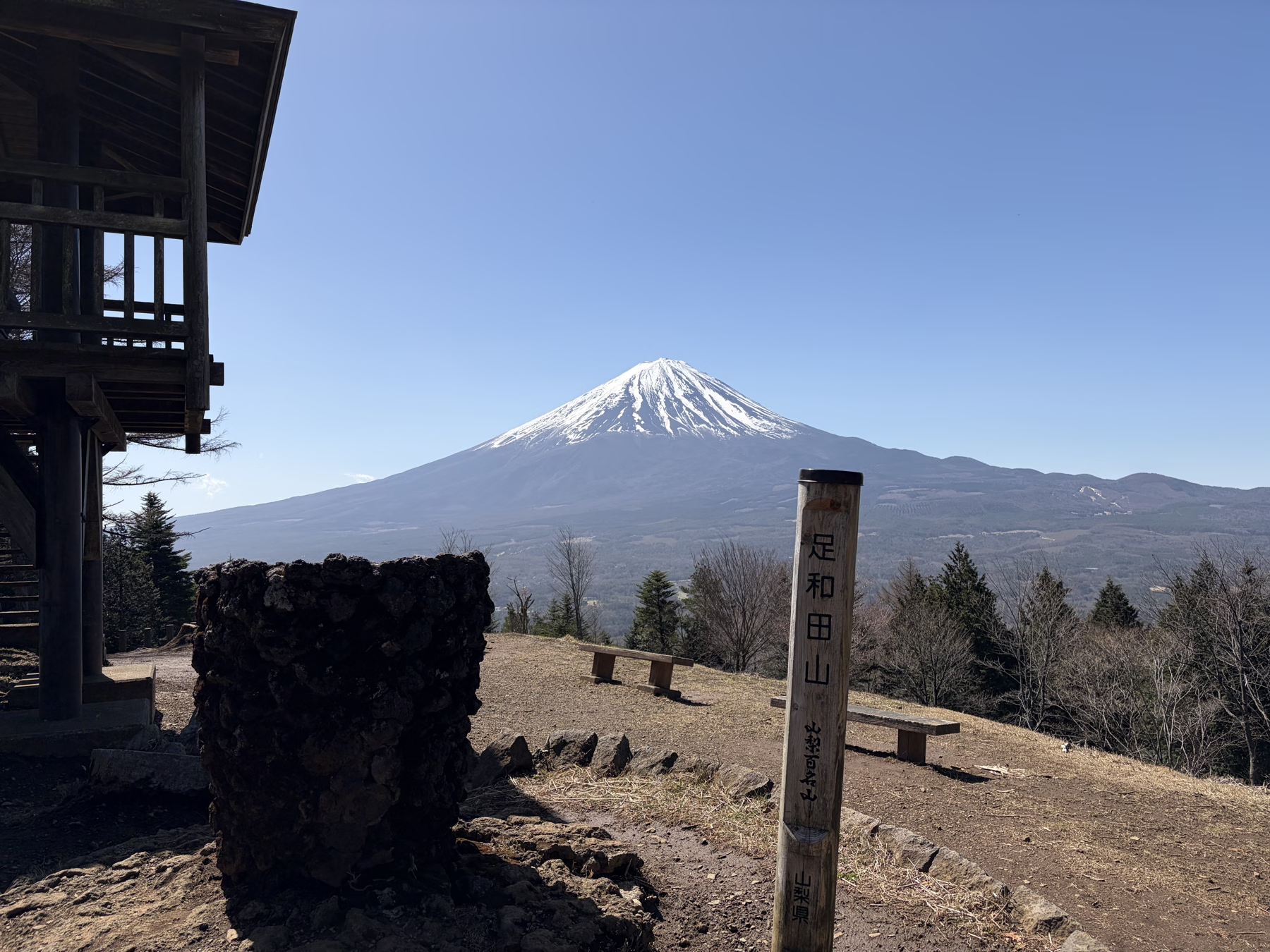
Photo by Yama-Nikki
Mt. Ashiwada (Gokodai) Hiking Report: Panoramic Ridge Walk Overlooking Mt. Fuji, Lake Saiko, and Aokigahara from Koyodai
Early-April hiking report and official trail guide for Mt. Ashiwada (Gokodai, 1,355 m) in Fujikawaguchiko and Narusawa, Yamanashi Prefecture. Covers the Tokai Nature Trail ridge walk from Koyodai via Sankodai to Gokodai, fork choices (steep vs. gentle bypass), parking at Koyodai Resthouse, and views of Mt. Fuji.
Mt. Ashiwada (足和田山, 1,355 m)—whose summit is also known as Gokodai (五湖台, "Five Lakes Terrace")—rises along the ridge between Lake Kawaguchiko and Lake Saiko in Fujikawaguchiko Town and Narusawa Village, Yamanashi Prefecture. Selected as one of the 100 Famous Mountains of Yamanashi (Yamanashi Hyakumeizan), it offers a gentle, family-friendly ridge walk along a model section of the Tokai Nature Trail (東海自然歩道) with sweeping views of Mt. Fuji, Lake Saiko, Lake Shojiko, Lake Motosuko, and the vast Aokigahara Jukai ("Sea of Trees") forest below.
(Note: As Yamanashi Prefecture's official tourism guide points out, although the summit is called "Gokodai" because the mountain stands near the center of the Fuji Five Lakes area, all five lakes cannot be seen simultaneously from the top.)
This article combines my early-April hike report—when crisp spring air gave us razor-sharp views of snow-clad Mt. Fuji and cherry blossoms were just starting to open around the foothills—with current official trail and access information from Narusawa Village and Yamanashi Prefecture.
Mountain Overview & Official Trail Times
| Item | Details |
|---|---|
| Mountain | Mt. Ashiwada / Gokodai (足和田山 / 五湖台, 1,355 m) |
| Location | Fujikawaguchiko Town & Narusawa Village, Minamitsuru District, Yamanashi Prefecture |
| Official Walking Time (One Way) | Koyodai (紅葉台) → Sankodai (三湖台): ~15–20 min Sankodai (三湖台) → Gokodai / Mt. Ashiwada Summit (五湖台): ~60 min (Total one way from Koyodai to Gokodai: ~1h 15m–1h 20m; round trip ~2h 30m–3h 00m) |
| Trail Corridor | Part of the Tokai Nature Trail (東海自然歩道) (1,697.2 km long-distance national trail linking Tokyo and Osaka) |
| Parking & Restrooms | Koyodai Resthouse (紅葉台レストハウス) at the Koyodai trailhead |
| Summit Facilities | Log observation deck, benches, and picnic tables at Gokodai (no mountain hut) |
| Map Location | View Mt. Ashiwada (Gokodai) on Google Maps |
Public Transit & Alternative Bus Trailheads (Yamanashi Prefecture Official Guide)
If you are traveling without a car from Kawaguchiko Station (河口湖駅) on the Fujikyuko Line, Yamanashi Prefecture's official guide lists three bus-accessible trailheads for climbing Mt. Ashiwada from the lakeside:
- Michi-no-Eki Katsuyama (道の駅かつやま) bus stop: 19 min by bus from Kawaguchiko Station + ~125 min on foot
- Ippon-gi (一本木) bus stop: 20 min by bus from Kawaguchiko Station + ~85 min on foot
- Kenashiyama Tozanguchi (毛無山登山口) bus stop: 24 min by bus from Kawaguchiko Station + ~105 min on foot
- By Car from Chuo Expressway: ~20 min from Kawaguchiko IC (plus ~120 min on foot if climbing from the base, or drive up the forest track to Koyodai Resthouse for the shorter ridge walk).
GPS Route Log
Hike Report: Koyodai → Sankodai → Mt. Ashiwada (Gokodai)
1. Approach Road & Parking at Koyodai Resthouse
For this hike, I parked at Koyodai Resthouse (紅葉台レストハウス) (Google Maps), which sits high on the western ridge and provides the shortest approach to Sankodai and Gokodai.
Be aware that the final ~10 minutes of the drive up to Koyodai Resthouse runs along a narrow, unpaved gravel track. Passing oncoming vehicles requires care, so take it slow—especially if you are driving a wide SUV or are unfamiliar with unpaved mountain lanes.

The parking area in front of Koyodai Resthouse is on private resthouse grounds. Rather than treating it as a free public lot, it is good trail etiquette to buy a drink or souvenir inside, or visit the rooftop observation deck (300 yen), which actually commands an even more unobstructed 360-degree panorama of Mt. Fuji and the Aokigahara forest than the wooded summit of Gokodai itself. When I thanked the staff for letting me park there after descending, they were genuinely appreciative.

2. Trail Conditions & Choosing Between Steep and Gentle Forks
From Koyodai Resthouse through Sankodai to the summit of Mt. Ashiwada (Gokodai), the ridge trail is wide, clearly signed, and free of exposed knife-edge drop-offs. However, because several sections are laced with exposed tree roots and eroded wooden steps, sturdy hiking boots or trekking shoes are much safer than flat sneakers.
Along the ridge between Sankodai and Gokodai, you will encounter roughly four trail forks where the path splits into two parallel options:
- Left fork: Steeper direct climb over steps and roots
- Right fork: Gentler contouring bypass path (maki-michi)
Both forks rejoin just ahead. If you want a brisk workout, take the left fork; if you are hiking with family or beginners—or want to save your knees on the return—the right-hand gentle path is much easier on the legs.


Watch your footing on the wooden staircase sections. In several places, soil has washed out from behind the timber risers, leaving uneven step heights and exposed pegs. Often it is easier to step carefully alongside the eroded timbers or use trekking poles for balance on the descent.

As you walk east along the ridge, glimpses of Lake Kawaguchiko appear through the deciduous trees to your left (north).

3. Detour to Sankodai (三湖台) — Overlooking Three Lakes & the Sea of Trees
Only 15–20 minutes on foot from Koyodai, the wide open lawn of Sankodai (三湖台, "Three Lakes Terrace") is a must-visit viewpoint on either the outbound or return leg. True to its name, Sankodai looks out over Lake Saiko, Lake Shojiko, and Lake Motosuko, together with the unbroken green carpet of Aokigahara Jukai (青木ヶ原樹海) stretching across the northwestern lava plateau of Mt. Fuji.

4. Summit of Mt. Ashiwada / Gokodai (五湖台, 1,355 m)
About 1 hour of pleasant forest walking past Sankodai, you arrive at the broad summit clearing of Mt. Ashiwada (Gokodai, 1,355 m). A log-built observation deck, benches, and picnic tables are set up in the plaza. On a clear day, Mt. Fuji towers directly ahead across the waters of Lake Saiko and Lake Shojiko, making an ideal spot for a summit lunch and trail snacks.
Key Takeaways for Planning Your Hike
- Beginner-Friendly Ridge Walk: Walking from Koyodai → Sankodai (15–20 min) → Gokodai (60 min) takes roughly 1 hour 15–20 minutes one way along a gentle section of the Tokai Nature Trail.
- Two Distinct Viewpoints: Combine the dramatic Mt. Fuji + Aokigahara Jukai panorama at Koyodai / Sankodai with the Mt. Fuji + Lake Saiko / Shojiko view from the log deck at Gokodai.
- Footwear & Clothing: Wear hiking boots for the tree roots and eroded wooden steps, and pack layered clothing for chilly breezes at 1,355 m in spring and autumn.