

Mt. Yoneyama Hiking Report (Odaira Course): Sea of Japan & Sado Views, Trail Conditions, and Yoneyama Hiking Base (2026)
First-hand Golden Week hiking report on Mt. Yoneyama (992 m, one of Japan's 300 Famous Mountains) via the Odaira Course in Kashiwazaki, Niigata: steep rope-assisted climbs, Ninoji rest area, Ganbare Rock, Sea of Japan and Sado Island views, summit bio-toilet season, and the new Yoneyama Hiking Base.
Introduction
Straddling the border between Kashiwazaki City and Kakizaki Ward of Joetsu City in Niigata Prefecture, Mt. Yoneyama (米山, 992 m) is one of Japan's 300 Famous Mountains (Nihon Sanbyakumeizan) and one of the Three Mountains of Kariwa (Kariwa Sanzan). Although its elevation is just under 1,000 meters (officially revised from 993 m to 992 m on April 1, 2025 per Kashiwazaki City's Mt. Yoneyama Overview), it rises as a prominent independent cone directly above the Sea of Japan coast, offering 360-degree views over Kashiwazaki, the Sea of Japan, Sado Island, and the Echigo peaks.
This report covers a round-trip Golden Week hike on April 30, 2026 up the classic Odaira Course (大平コース) from the Kashiwazaki side (trailhead elevation 323.1 m, elevation gain approx. 670 m, official standard ascent time approx. 2 hours 30 minutes excluding breaks), along with the latest 2026 facility updates for the summit bio-toilet and the newly opened Yoneyama Hiking Base (米山ハイキングベース) at the Odaira trailhead.
1. Mt. Yoneyama & Odaira Course Overview
| Item | Official Details |
|---|---|
| Location | Kashiwazaki City & Kakizaki Ward, Joetsu City, Niigata Prefecture |
| Elevation | 992 m (First-class triangulation station; revised April 1, 2025) |
| Route Walked | Odaira Course (大平コース) round-trip |
| Trailhead Elevation | 323.1 m (Lat 37.294749, Lon 138.462976) |
| Official Standard Ascent Time | Approx. 2 hours 30 minutes one-way from trailhead to summit (excluding rest stops) |
| Access to Odaira Trailhead | Approx. 15 min by car (8.3 km) from Yoneyama IC on the Hokuriku Expressway; or approx. 1 hour on foot (4.2 km) from JR Shin-etsu Main Line Yoneyama Station |
| Trailhead Rest Facility & Parking | Yoneyama Hiking Base (643 Odaira, Kashiwazaki; free, open year-round with restrooms, changing rooms, Wi-Fi, AED, and foot wash). Parking Lot 1: 15 standard cars (free, 15-min walk to trailhead). Parking Lot 2: 15 standard cars / 3 large buses (free, 5-min walk to Yoneyama Hiking Base; closed to cars on days when a large bus reservation is booked) |
| Summit Facilities | Yoneyama Yakushido Hall (米山薬師堂), unmanned Summit Emergency Shelter Hut (山頂避難小屋), and seasonal Summit Bio-Toilet (open May 8 – mid-November 2026; dismantled during winter/early spring—still closed on April 30, 2026) |
2026 Facility Update: Yoneyama Hiking Base & Summit Bio-Toilet
- During our April 30, 2026 hike: Construction on the large-bus parking lot at Odaira was still wrapping up (with full closures on specific workdays in late April/early May), and the collapsible summit bio-toilet was still in its winter dismantled state, making the trailhead toilet the last restroom before the climb.
- Current 2026 Status (Kashiwazaki City Official Notice): The new Yoneyama Hiking Base rest house and Parking Lots 1 & 2 (15 standard cars each, free) are now completed and open year-round. In addition, the Mt. Yoneyama Summit Bio-Toilet was reassembled and is open from May 8 to mid-November 2026 (scheduled).
2. Route Map and Key Waypoints
| Waypoint | Highlights & Notes |
|---|---|
| Odaira Parking Area (323.1 m) | Start of the walk; use restrooms before departing |
| Initial Climb & Forest Road | Steep wooded ascent from the parking area, followed by a short paved forest-road breather |
| Mt. Yoneyama Trailhead Sign | Bear warning signs and start of the main mountain path (also the soil-bag pickup point for the voluntary Mt. Yoneyama Soil-Carrying Conservation Campaign held mid-May to early November) |
| Ninoji Clearing (~650 m) | Open rest area with a direct view of Mt. Yoneyama's upper cone |
| Peak 711 m & Beech Ridge | About 20 minutes of gentler ridge walking with benches and views |
| Ganbare Rock (ガンバレ岩) | Landmark boulder on the upper beech-forest climb before the summit push |
| Mt. Yoneyama Summit (992 m) | Summit post, Yoneyama Yakushido Hall, emergency shelter hut, and panoramic views of the Sea of Japan and Sado Island |
3. Trail Report: Step by Step on the Odaira Course (April 30, 2026)
Odaira Parking Area to the Mountain Trailhead
Reached in about 15 minutes by car from Yoneyama IC on the Hokuriku Expressway, the Odaira parking area had a temporary toilet available on April 30, 2026 (now supplemented by the permanent year-round Yoneyama Hiking Base).

From the parking area, a directional sign points hikers toward the trailhead. Rather than easing in gradually, the path immediately climbs a steep dirt-and-root slope through the forest before your legs have fully warmed up.
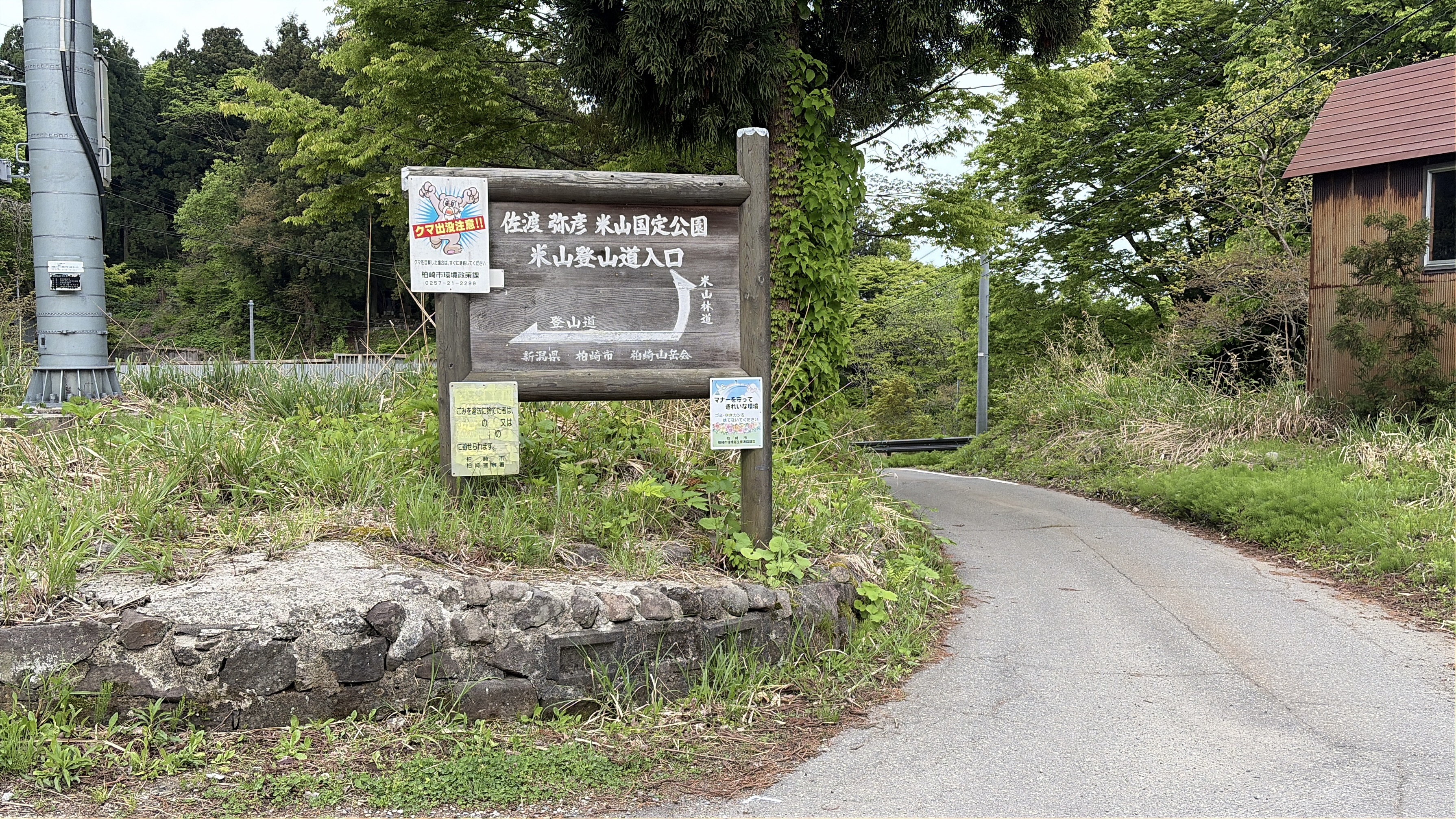

Topping out on this first pitch brings you onto a paved forest road lined with cedar trees, offering a brief flat stretch to catch your breath.

Walking about 5 minutes along the forest road leads to the main Mt. Yoneyama trailhead sign and bear warning boards. Make sure your bear bell is active before entering the forest.


Trailhead to the Ninoji Clearing (~650 m)
As soon as you step past the trailhead sign, another sustained steep climb begins. Fixed ropes assist on high steps, and the dirt surface is laced with tree roots and fallen leaves that require deliberate foot placement on both the ascent and descent.


Finishing this steep forest climb brings you out onto Ninoji (二ノ字) at around 650 m elevation—an open clearing where the upper pyramid of Mt. Yoneyama comes into full view. It is the best spot on the lower half of the mountain to stop for water and energy snacks.

Ninoji (~650 m) via the Ridge and Ganbare Rock to the Upper Snow Line
Beyond Ninoji, the grade eases into a pleasant ridge walk for roughly 20 minutes around Peak 711 m. Low shrubs overhang the trail at head height in several places, so watch above your head as well as your footing.

After the ridge breather, the trail pitches steeply upward again through narrow rocky and rooty terrain with fixed ropes.

On April 30, 2026, a fallen tree partially blocked one section of the upper trail—passable with care, but requiring hikers to duck branches and watch their balance, especially on the return descent.

Continuing up the beech slope brings you to the landmark boulder "Ganbare Rock" (頑張れ石 / ガンバレ岩), whose painted message ("Hang in there!") marks the start of the final push.

Approaching the summit in late April, patches of compact spring snow appeared first along the sides of the path and then across the trail tread itself. While firm enough to walk on that morning, lingering spring snow on steep slopes can cause slips or post-holing as daytime temperatures rise.


Mt. Yoneyama Summit (992 m) and Descent
Emerging from the snow-patched upper trail brings you onto the spacious summit plaza of Mt. Yoneyama (992 m), crowned by its wooden summit post, Yoneyama Yakushido Hall (counted among the Three Great Yakushi shrines of Japan), and the unmanned summit shelter hut.

Looking northwest across the Sea of Japan, the coastline of Kashiwazaki and the silhouette of Sado Island across the water were clearly visible—a rewarding contrast to the steep forest climb below.

We descended by the same Odaira Course, taking extra care on the lingering snow patches, the fallen-tree bypass, and the steep root-and-rope sections below Ninoji.
4. Practical Safety Tips for Hiking the Odaira Course
- Don't underestimate a 992 m coastal peak: Starting from 323.1 m, the Odaira Course climbs nearly 670 m with steep pitches right from the start. Wear supportive hiking boots and carry rainwear, a warm layer for the windy summit, and plenty of water.
- Check the seasonal summit toilet dates: The Mt. Yoneyama Summit Bio-Toilet operates from May 8 to mid-November 2026 and is dismantled from mid-November through early May. During late April / Golden Week or late autumn, always use the restrooms at Yoneyama Hiking Base before starting.
- Prepare for lingering snow in late April / Golden Week: Even when fresh green leaves are out on the lower slopes, snow patches remain near the 992 m summit in late April and early May; carry light traction (chain spikes) if hiking in spring.
- Bear safety: Carry a bear bell and check Kashiwazaki City's bear alerts before heading out.
Official References & Related Guides
- Kashiwazaki City Official Portal: Mt. Yoneyama Top Page
- Kashiwazaki City: Odaira Course Guide
- Kashiwazaki City: Highlights of Mt. Yoneyama (992 m)
- Kashiwazaki City: Yoneyama Hiking Base (Odaira Trailhead Rest Facility & Parking Lots 1 & 2)
- Kashiwazaki City: Mt. Yoneyama Summit Bio-Toilet Operating Season (May 8 – Mid-Nov 2026)
- Kashiwazaki City: Mt. Yoneyama Soil-Carrying Conservation Campaign