

Photo: Alpsdake, Wikimedia Commons (CC BY-SA 3.0)

Mt. Yakedake Hiking Guide: The Only Active Volcano in the Northern Alps via Shin-Nakanoyu and Kamikochi
Complete guide to hiking Mt. Yakedake (2,455 m, North Peak 2,444 m), the only active volcano in the Northern Alps and one of the 100 Famous Japanese Mountains. Covers the Shin-Nakanoyu Route, the Kamikochi Route ladders, JMA volcanic alert checks, and helmet safety.
Rising to 2,455 m on the border of Nagano and Gifu Prefectures, Mt. Yakedake (焼岳) is one of the 100 Famous Japanese Mountains (Nihon Hyakumeizan) and the only active volcano in the Northern Alps (Hida Mountains).
Standing at the southern gateway to Kamikochi (上高地), Mt. Yakedake is famous for the plumes of volcanic steam rising from its upper flanks, the emerald-green crater lake inside its summit basin, and its front-row view of the Hotaka Range (Mt. Oku-Hotakadake, Mt. Mae-Hotakadake, Mt. Nishi-Hotakadake) and Mt. Kasagatake across the Azusa River valley. Look back toward the valley floor and you can also see Taisho Pond (大正池), which was formed in 1915 when a major eruption of Mt. Yakedake sent mudflows damming the Azusa River.
Despite its dramatic alpine scenery, the standard Shin-Nakanoyu Route (新中の湯ルート) can be completed in about 4.5 to 5.5 hours round trip—making Mt. Yakedake one of the most accessible gateways to the Northern Alps. Because it is an active volcano, however, checking the latest Japan Meteorological Agency (JMA) Volcanic Alert Level and carrying a climbing helmet are mandatory before you set out.

Overview of Mt. Yakedake
| Item | Details |
|---|---|
| Elevation | 2,455 m (South Peak — closed to entry); North Peak (北峰, 2,444 m) is the highest point open to hikers |
| Location | Matsumoto City, Nagano Prefecture / Takayama City, Gifu Prefecture |
| Trailhead Elevation | Approx. 1,610 m (Shin-Nakanoyu Trailhead) / Approx. 1,500 m (Kamikochi Trailhead) |
| Elevation Gain | Approx. 835 m (Shin-Nakanoyu Route) / Approx. 945 m (Kamikochi Route) |
| Standard Walking Time | Approx. 4 hr 30 min – 5 hr 30 min (Shin-Nakanoyu round trip) / Approx. 6 hr – 7 hr (Kamikochi round trip) |
| Nagano Trail Grade | Shin-Nakanoyu Route: Stamina 2 / Technical Difficulty B Kamikochi Route: Stamina 3 / Technical Difficulty C (long steel ladders) |
| Best Season | Early June to Mid-October (Mid-June–August for fresh greenery; late September–mid-October for autumn foliage) |
| Restrooms | Shin-Nakanoyu Trailhead: No restroom (use the public restrooms at Hirayu Bus Terminal, Sawando Parking, or Kamikochi Bus Terminal before starting); Yakedake-goya Hut (paid mountain toilet when open) |
| Mountain Hut | Yakedake-goya (焼岳小屋, approx. 2,070 m on the Kamikochi side) |
| Volcanic Alert Check | Always check JMA Volcanic Warnings before climbing; entry is prohibited at Alert Level 2 or higher |
North Peak (2,444 m) vs. South Peak (2,455 m)
Mt. Yakedake has twin summit peaks:
- South Peak (
南峰, 2,455 m): The geographical high point, which is permanently closed to entry due to rockfall and structural collapse hazards. - North Peak (
北峰, 2,444 m): The actual summit for hikers, where the summit marker stands and where both the Shin-Nakanoyu and Kamikochi routes converge.
All climbs of Mt. Yakedake target the North Peak (2,444 m).
Highlights of Mt. Yakedake
1. Live Volcanic Landscapes: Fumaroles and an Emerald Crater Lake
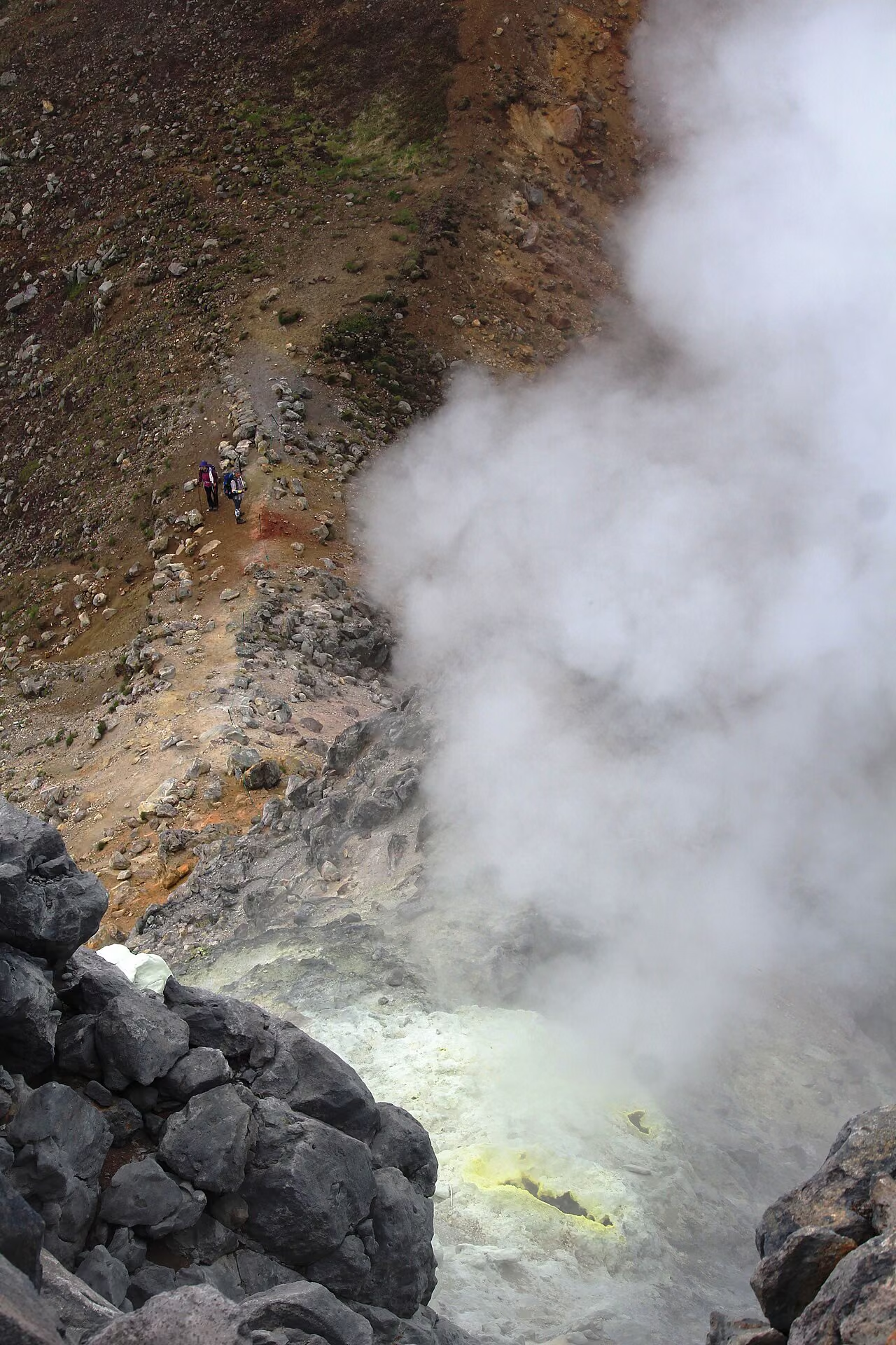
Above the treeline at around 2,000 m, the forest gives way to pale volcanic rock, sulfur-stained vents, and steaming fumaroles (噴気孔) emitting a faint smell of hydrogen sulfide. Near the saddle between the North and South Peaks lies Shoga-ike (正賀池), a vivid emerald-green crater lake tucked inside the volcanic basin.

2. Front-Row Views of the Hotaka Range, Kamikochi, Mt. Kasagatake & Mt. Norikuradake
From the North Peak (2,444 m), you look directly across at the towering rock walls of the Hotaka Range (穂高連峰) just to the north, with the green valley of Kamikochi and the winding Azusa River 950 m directly below your feet. To the west stands the graceful pyramid of Mt. Kasagatake (笠ヶ岳), and to the south rises the broad volcanic massif of Mt. Norikuradake (乗鞍岳, 3,026 m).
3. The Volcano That Created Taisho Pond in Kamikochi
On June 6, 1915 (Taisho 4), a phreatic eruption on Mt. Yakedake sent a massive mudflow (lahar) down into the Azusa River, damming the valley overnight and submerging the surrounding larch forest to create Taisho Pond (大正池). Looking down on Taisho Pond from the summit—or walking along its shoreline after descending to Kamikochi—connects the mountain's living geology with Kamikochi's most iconic scenery.


Choosing Your Route: Three Approaches Compared
| Route | Round-Trip / Traverse Time | Elevation Gain | Nagano Grade | Key Characteristics |
|---|---|---|---|---|
1. Shin-Nakanoyu Route (新中の湯ルート) |
Approx. 4 hr 30 min – 5 hr 30 min (round trip) | ~835 m | Stamina 2 / Tech B | Most popular day-hike route. Only route accessible by private car; no long vertical ladders |
2. Kamikochi Route (上高地ルート) |
Approx. 6 hr – 7 hr (round trip) | ~945 m | Stamina 3 / Tech C | Starts from Kamikochi; passes Yakedake-goya Hut and climbs a famous ~7 m vertical steel ladder |
| 3. Shin-Nakanoyu → Kamikochi Traverse | Approx. 5 hr – 6 hr (one-way traverse) | +835 m / -945 m | Stamina 3 / Tech C | Best of both sides; requires bus/taxi logistics between Kamikochi and Nakanoyu |
Detailed Guide: Shin-Nakanoyu Route (Standard Day-Hike Route)
Shin-Nakanoyu Trailhead (~1,610 m, National Route 158)
  │ Approx. 1 hr 30 min (steady climb through beech and conifer forest)
  ▼
Hiroba Meadow / Treeline Bench (~2,060 m)
  │ Approx. 1 hr 15 min (open volcanic gravel slope + rocky scramble to saddle)
  ▼
North–South Peak Saddle (~2,350 m) → North Peak Summit (2,444 m)
  │ Approx. 2 hr (retrace route to Shin-Nakanoyu Trailhead)
  ▼
Shin-Nakanoyu Trailhead (~1,610 m)
Section 1: Shin-Nakanoyu Trailhead to Hiroba Meadow (~2,060 m) — Approx. 1 hr 30 min
The Shin-Nakanoyu Trailhead (新中の湯登山口, ~1,610 m) sits right along National Route 158 above the Abo Tunnel portal. There are no toilets or vending machines at this trailhead, so always stop at Hirayu Bus Terminal or Sawando Parking beforehand.
The trail climbs steadily through cool beech, birch, and subalpine conifer forest. Tree roots and damp volcanic soil can be slick after rain, so pace yourself as you gain the first 450 vertical meters.
Section 2: Hiroba Meadow (~2,060 m) to North Peak Summit (2,444 m) — Approx. 1 hr 15 min
Around 2,060 m, the forest opens suddenly at a small rest bench (広場), revealing the pale volcanic dome of Mt. Yakedake directly ahead. Put on your climbing helmet here before entering the open volcanic slope.
From the bench, the path climbs across loose volcanic gravel and pumice before curving around the base of the closed South Peak toward the saddle (鞍部) between the South and North Peaks. From the saddle, you look directly down into the emerald waters of Shoga-ike crater lake and across to steaming fumaroles.
The final stretch from the saddle to the North Peak (2,444 m) is a short, steep rock scramble using hands and feet (三点支持, three-point contact) past active steam vents. Do not linger right beside fumaroles—volcanic gases are denser than air and collect in depressions when wind is light.


Section 3: Descent (North Peak to Shin-Nakanoyu Trailhead) — Approx. 2 hr
Wait for ascending hikers on the narrow rocky steps below the North Peak, avoid kicking loose stones down the volcanic scree slope above the treeline, and use trekking poles once back on the gentler trail to protect your knees.
Kamikochi Route Notes (Technical Difficulty C)
If you climb or descend via the Kamikochi Route (上高地ルート) passing Yakedake-goya (焼岳小屋) and Nakanoyu Pass (中尾峠):
- Between the forest zone and Yakedake-goya stands a nearly vertical steel ladder approximately 7 m high, along with shorter ladders and chain-assisted rock steps. Anyone uncomfortable with heights or vertical ladders should use the Shin-Nakanoyu Route instead.
- Remember that Kamikochi is closed to private cars year-round (and closed for the winter from November 16 to mid-April), so you must ride the shuttle bus or taxi from Sawando Parking (
沢渡駐車場, Nagano side) or Akandana Parking (あかんだな駐車場, Gifu/Hirayu side), and catch the last bus out of Kamikochi in the afternoon.
Access and Parking
1. Shin-Nakanoyu Trailhead (By Car or Bus)
- By Car:
- From the Nagano side: Nagano Expressway Matsumoto IC (
松本IC) → National Route 158 west (~1 hr). - From the Gifu/Kansai/Chubu side: Chubu Jukan Expressway Takayama IC (
高山IC) → National Route 158 east via Abo Tunnel (~45 min).
- From the Nagano side: Nagano Expressway Matsumoto IC (
- Parking at Shin-Nakanoyu Trailhead:
- Free roadside parking pullouts along National Route 158 right at the trailhead (approx. 15–20 cars total).
- No restrooms at the trailhead. On sunny summer and autumn weekends, the pullouts often fill before 5:00–5:30 AM. If full, never park illegally along the highway curve—drive down to Hirayu Bus Terminal or Sawando Parking and take a bus (
Nakanoyubus stop + uphill walk) or taxi (~10–15 min from Hirayu or Sawando) to the trailhead.
2. Kamikochi Trailhead (Public Transit / Shuttle Bus)
- Park at Sawando Parking (
沢渡駐車場) on the Nagano side or Akandana Parking (あかんだな駐車場) near Hirayu Onsen on the Gifu side, or take a highway bus from Matsumoto, Takayama, Shinjuku, Nagoya, or Kyoto/Osaka to Taisho-ike (大正池) or Kamikochi Bus Terminal (上高地バスターミナル), then walk ~30 min along the Azusa River to the Mt. Yakedake Trailhead (焼岳登山口) near Empire Hotel.
Essential Safety Rules: Active Volcano & Helmet
- Check the JMA Volcanic Alert Level Immediately Before Departure:
- Mt. Yakedake is continuously monitored by the Japan Meteorological Agency (JMA).
- At Alert Level 1 (Potential for increased activity), the North Peak trail is open. If the alert is raised to Level 2 (Crater area regulation) or higher, entry within roughly 1 km of the summit crater is strictly prohibited by law.
- Wear a Climbing Helmet Above the Treeline:
- Both Nagano and Gifu Prefectures designate Mt. Yakedake as a helmet-recommended mountain (protecting against both rockfall on the upper scramble and volcanic ballistic ejecta). Emergency rental helmets are also available at surrounding facilities such as Kamikochi Visitor Center and Yakedake-goya.
- Never Stop Near Fumaroles or in Windless Depressions:
- Hydrogen sulfide (
H₂S) and sulfur dioxide (SO₂) gases vent around the upper saddle and North Peak. Pass fumarole zones briskly without sitting down in low hollows.
- Hydrogen sulfide (
Summary
Mt. Yakedake rewards hikers with live volcanic fumaroles, an emerald crater lake, and one of the finest close-up panoramas of the Hotaka Range and Kamikochi—all within a 4.5 to 5.5-hour round-trip day hike via the Shin-Nakanoyu Route. Check the JMA volcanic alert before leaving home, pack a helmet and full alpine rain and warm layers, and enjoy the Northern Alps' only active volcano safely.
Reference Links
- Japan Meteorological Agency (JMA) — Volcanic Warnings and Alert Levels
- Japan Meteorological Agency (JMA) — Mt. Yakedake Volcanic Activity Information
- Nagano Prefecture — Mountain Climbing Safety & Information
- Nagano Prefecture — Nagano Trail Grading System
- Nagano Prefecture — Trail Grading Matrix PDF
- Kamikochi Official Website
- Matsumoto City Official Website