

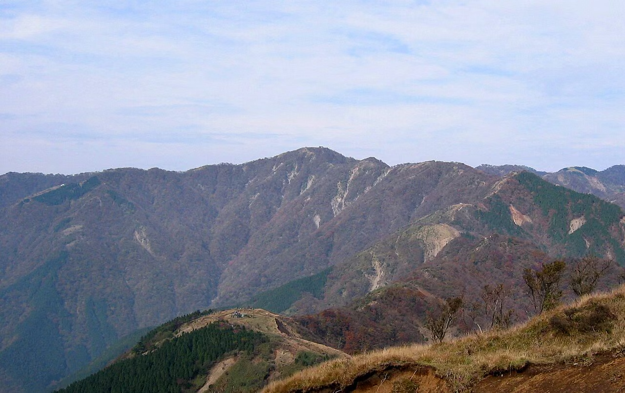
Photo: Σ64, Wikimedia Commons (CC BY 3.0)

Mt. Tanzawa & Mt. Tonodake Hiking Guide: Conquering the Okura Ridge, Yamabiru Leech Prevention, and Access
A complete day-hiking guide to Mt. Tanzawa (1,567 m) and Mt. Tonodake (1,491 m) in Kanagawa Prefecture via the famous Okura Ridge ('Baka-One'). Covers three route options, cumulative elevation gain, land leech (yamabiru) prevention, and bus and parking access from Shibusawa Station.
Rising across northwestern Kanagawa Prefecture within Tanzawa-Oyama Quasi-National Park, the Tanzawa Mountains are one of the Kanto region's premier year-round hiking grounds. Mt. Tanzawa (丹沢山, 1,567 m) represents the entire range in Kyuya Fukada's Nihon Hyakumeizan (100 Famous Japanese Mountains) and sits along the beech-forested Tanzawa Main Ridge (丹沢主脈) roughly midway between Mt. Tonodake (塔ノ岳, 1,491 m) and Mt. Hirugatake (蛭ヶ岳, 1,673 m)—the highest peak of both the Tanzawa range and Kanagawa Prefecture.
Although Mt. Tanzawa stands under 1,600 meters, reaching it from the main southern trailhead at Okura (大倉, 290 m) requires climbing the famous Okura Ridge (大倉尾根)—affectionately nicknamed the "Baka-One" (バカ尾根, "Relentless Ridge") by local hikers for its steady 1,200-meter ascent to Mt. Tonodake—before continuing along the rolling main ridge. A round trip to Mt. Tanzawa covers roughly 19.4 km with 1,380 m of cumulative elevation gain and 8.5 to 9 hours of walking time, making it a serious fitness test on par with Japanese Alps ascents.
This guide breaks down the relationship between Mt. Tonodake, Mt. Tanzawa, and Mt. Hirugatake, compares three classic routes from Okura, explains how to pace the Okura Ridge, details seasonal land leech (yamabiru) prevention, and covers train, bus, and parking access.
Mountain Overview & Basic Data
| Item | Details |
|---|---|
| Mountain Names & Elevations | Mt. Tanzawa (丹沢山): 1,567 m (100 Famous Japanese Mountains representative peak) Mt. Tonodake (塔ノ岳): 1,491 m (highest peak of the Omote-One ridge) Mt. Hirugatake (蛭ヶ岳): 1,673 m (highest peak of the Tanzawa range & Kanagawa Prefecture) |
| Location | Hadano City, Kiyokawa Village, and Yamakita Town, Kanagawa Prefecture |
| Park Designation | Tanzawa-Oyama Quasi-National Park / Kanagawa Prefectural Tanzawa-Oyama Nature Park |
| Main Trailhead | Okura (大倉, elev. 290 m) — adjacent to Kanagawa Prefectural Hadano Togawa Park |
| Standard Walking Time | Mt. Tonodake round-trip: ~6h 00m (~13.5–14.0 km, +1,200 m) Mt. Tanzawa round-trip: ~8h 30m–9h 00m (~19.4 km, +1,380 m) Mt. Nabewari–Mt. Tonodake loop: ~7h 30m–7h 50m (~16.8 km, +1,350 m) |
| Summit Mountain Huts | Sonbutsu Sanso (尊仏山荘) at Mt. Tonodake summit; Miyama Sanso (みやま山荘) at Mt. Tanzawa summit (advance reservation required for overnight stays) |
| Best Seasons | Late October to March (crisp air, clear Mt. Fuji views, no land leeches) and mid-April to May (fresh beech greenery) |
2026 Trail & Summit Advisories
According to the Kanagawa Prefecture Tanzawa-Oyama Park Trail Information page (checked October 24, 2026):
- Mt. Tonodake Summit Post Repainting (until late November 2026): On trails
T03(Tanzawa Main Ridge) andT09(Okura Ridge) at the summit of Mt. Tonodake, the wooden summit marker post is surrounded by scaffolding for repainting work through around late November 2026. The summit area and trails remain open for passage, but the summit marker sign itself is covered during the work. - Yushin–Tonodake Trail (
T23) Closure: The section of the Yushin–Tonodake Trail between Mt. Tonodake and Sonbutsu-no-Dodaira remains closed for safety inspection. Stick to the standard Okura Ridge (T09), Tanzawa Main Ridge (T03), Omote-One (T07), and Nabewari Ridge (T10) routes.
Understanding the Three Core Peaks: Mt. Tonodake, Mt. Tanzawa, and Mt. Hirugatake
Before planning your itinerary, it helps to understand how the three signature peaks along the Tanzawa Main Ridge differ in character and effort:
- Mt. Tonodake (塔ノ岳, 1,491 m) — The 360-Degree Viewpoint: Sitting at the top of the Okura Ridge where the Omote-One and Nabewari ridges converge, Mt. Tonodake has a wide, open summit plaza with sweeping views of Mt. Fuji, Sagami Bay, the Izu Peninsula, Enoshima, and the Tokyo–Yokohama skyline. For first-time Tanzawa hikers or those stepping up from Mt. Takao (599 m) and Mt. Oyama (1,252 m), making Mt. Tonodake your turnaround goal (~6 hours round-trip) offers the best balance of effort and panoramic reward.
- Mt. Tanzawa (丹沢山, 1,567 m) — Quiet Beech Forests & Hyakumeizan Goal: Located 2.5 km (~90 minutes outbound, ~75 minutes return) north of Mt. Tonodake along the Tanzawa Main Ridge, Mt. Tanzawa is surrounded by tranquil beech (Fagus crenata) and sasa bamboo forests, with Mt. Fuji framed across the ridge openings. Because it adds roughly 2.5 to 3 hours of round-trip walking and several intermediate ups and downs (including Hinokiboramaru and Ryugabamba), hikers aiming for Mt. Tanzawa as a day hike should turn back at Mt. Tonodake if they have not reached Tonodake by 11:00 AM.
- Mt. Hirugatake (蛭ヶ岳, 1,673 m) — Highest Peak in Kanagawa Prefecture: Continuing beyond Mt. Tanzawa along the main ridge via Mt. Fudounomine and Onigaiwa leads to Mt. Hirugatake, the highest summit in Kanagawa Prefecture. A full out-and-back from Okura to Mt. Hirugatake exceeds 25 km and 11–12 hours, so most hikers tackle Hirugatake as a two-day hut traverse staying at Sonbutsu Sanso, Miyama Sanso, or Hirugatake Sanso.

Comparing the 3 Best Routes from Okura
All three classic routes below start and finish at the Okura (大倉) bus terminal, making logistics equally simple whether you arrive by Odakyu train + bus or park at Hadano Togawa Park.
| Route | Round-Trip Time | Distance | Cumulative Gain | Difficulty | Best For |
|---|---|---|---|---|---|
| 1. Okura Ridge to Mt. Tonodake (Round-Trip) | ~6h 00m | ~13.5–14.0 km | ~1,200 m | Intermediate | First Tanzawa hike; 360° summit views of Mt. Fuji & Sagami Bay |
| 2. Okura Ridge to Mt. Tanzawa (Round-Trip) | ~8h 30m–9h 00m | ~19.4 km | ~1,380 m | Intermediate–Advanced | Bagging the Hyakumeizan summit; quiet beech-ridge walking |
| 3. Mt. Nabewari to Mt. Tonodake Loop | ~7h 30m–7h 50m | ~16.8 km | ~1,350 m | Intermediate | Varied scenery + famous Nabeyaki Udon at Nabewari Sanso |
Route 1 & Route 2: Detailed Guide to the Okura Ridge ("Baka-One") & Mt. Tanzawa
Segment-by-Segment Walking Times (Hadano City Tourism Association Standard)
- Ascent to Mt. Tonodake (~3h 30m–3h 40m): Okura Bus Stop (290 m) → (40 min / 2.2 km) → Zojiba-no-Daira (雑事場ノ平) → (40 min / 1.4 km) → Komadome Chaya (駒止茶屋) → (30 min / 1.0 km) → Ogusadaira (小草平) → (30 min / 0.5 km) → Tenjin-One Junction (天神尾根分岐) → (30 min / 0.6 km) → Hanatate Sanso (花立山荘, ~1,300 m) → (20 min / 0.5 km) → Kinbyashi-no-Atama (金冷シノ頭) → (30 min / 0.55 km) → Mt. Tonodake (塔ノ岳, 1,491 m)
- Extension from Mt. Tonodake to Mt. Tanzawa (~1h 30m outbound / ~1h 15m return): Mt. Tonodake (1,491 m) → (45 min) → Ryugabamba (竜ヶ馬場) → (45 min / 2.5 km total from Tonodake) → Mt. Tanzawa (丹沢山, 1,567 m)
- Descent from Mt. Tonodake to Okura (~2h 20m–2h 30m): Mt. Tonodake → (25 min) → Hanatate Sanso → (45 min) → Ogusadaira → (30 min) → Komadome Chaya → (45 min) → Okura Bus Stop


1. Lower Section: Okura to Komadome Chaya & Ogusadaira
From the Okura bus stop (290 m)—where restrooms, coin lockers, vending machines, and the Hadano Visitor Center are located—follow the paved lane past farmland into a cool cedar and cypress forest. Numbered trail posts (大倉尾根 1 through 49) mark your progress all the way to the summit of Mt. Tonodake.
The initial stretch past Kannon Chaya (観音茶屋) and Zojiba-no-Daira (雑事場ノ平) warms up your legs on gentle forest gradients before steepening onto wooden steps below Komadome Chaya (駒止茶屋) and Horikiri-no-Ie (堀山の家). Keep your stride short and steady here; starting too fast on the lower ridge is the most common cause of leg cramps above 1,000 meters.
2. Upper Section: Tenjin-One Junction to Hanatate Sanso & Mt. Tonodake
Above Ogusadaira (小草平) and the Tenjin-One Junction (天神尾根分岐), the cedar canopy gives way to deciduous broadleaf forest and long staircases of wooden steps and cobblestone erosion-control paths. As you approach Hanatate Sanso (花立山荘, ~1,300 m), look back over your shoulder: the view opens dramatically across the Hadano Basin, Sagami Bay, Enoshima, and on clear days the Boso and Izu Peninsulas.
Above Hanatate Sanso, traverse the narrow ridge past Kinbyashi-no-Atama (金冷シノ頭)—where the Nabewari Ridge joins from the west—and climb the final wooden stairs to the broad summit of Mt. Tonodake (1,491 m).


3. Tanzawa Main Ridge: Mt. Tonodake to Mt. Tanzawa
If you have arrived at Mt. Tonodake with plenty of time and energy in reserve (ideally before 10:30–11:00 AM), take the trail descending north from behind Sonbutsu Sanso onto the Tanzawa Main Ridge (丹沢主脈).
Note that the path drops roughly 100 meters of elevation right after leaving Mt. Tonodake—a descent you will have to climb back up on your return leg! Beyond the initial saddle, the ridge becomes a peaceful wooden boardwalk and dirt path winding through native beech forest and sasa grass past Hinokiboramaru (日高) and the open rest benches at Ryugabamba (竜ヶ馬場), where Mt. Fuji and Mt. Hirugatake come into view. About 90 minutes from Mt. Tonodake, you reach the forested summit of Mt. Tanzawa (1,567 m) and Miyama Sanso (みやま山荘).


Route 3: Mt. Nabewari to Mt. Tonodake Loop (~7h 30m–7h 50m)
If you prefer a loop rather than climbing and descending the Okura Ridge twice, ascend via Mt. Nabewari (鍋割山, 1,272.5 m) and traverse the scenic Nabewari Ridge (鍋割山稜) to Mt. Tonodake before descending the Okura Ridge:
- Course Breakdown: Okura → (1h 30m–1h 45m along the flat Nishiyama Forest Road) → Futamata (二俣) → (50 min across Mizuhizawa stream crossings) → Ushirozawa-Nokkosu (後沢乗越) → (1h 30m steep beech-ridge climb) → Mt. Nabewari (1,272.5 m) → (1h 30m via Komaru, Omaru, and Kinbyashi-no-Atama) → Mt. Tonodake (1,491 m) → (2h 30m via Okura Ridge) → Okura.
- Note on Vehicle Access: Some older maps show parking near Omote-Tanzawa Prefectural Forest, but the Nishiyama Forest Road (西山林道) is closed to general motor vehicles—all hikers walk from Okura.
- Nabewari Sanso (鍋割山荘): Famous for its piping-hot Nabeyaki Udon served at the summit of Mt. Nabewari. Operating days and hours vary by season and weather, so always carry your own trail lunch and stove/snacks as a backup.
Land Leech (Yamabiru) Season, Prevention & First Aid
One of the most important things to know about hiking in the eastern and central Tanzawa Mountains is the presence of land leeches (yamabiru / ヤマビル, Haemadipsa zeylanica japonica). According to Kanagawa Prefecture's official Yamabiru advisory, land leeches are cylindrical (2–5 cm long, stretching to 5–7 cm), live in damp leaf litter along valley floors and lower forest trails, detect carbon dioxide in breath and body heat, and crawl toward hikers at roughly 1 meter per minute.
Activity Calendar by Month
| Season | Months | Yamabiru Risk | Notes |
|---|---|---|---|
| Winter & Early Spring | December – March | None | Leeches are dormant underground; crisp air and best views of Mt. Fuji. |
| Spring | April – May | Low to Moderate | Active on rainy or warm, humid days along lower valley trails. |
| Rainy Season & Summer | June – September | Peak (Very High) | Highest activity during and immediately after rain or fog. |
| Autumn | October – November | Moderate to Low | Subsides as temperatures drop below 10°C in late October–November. |
3-Step Leech Prevention Protocol
- Eliminate Skin Gaps at the Ankles: Wear long trekking pants (never shorts or bare ankles in May–October), tuck pant cuffs or wear long socks plus hiking gaiters (spats), and keep your shirt tucked in.
- Apply Dedicated Leech Repellent Before Stepping onto the Trail: Spray a dedicated leech repellent (such as Hiru-Sagari no Johnny or a high-concentration DEET/icaridin spray) thoroughly around your boot soles, eyelets, socks, and gaiters at the Okura trailhead, and reapply every 1–2 hours if walking through wet grass or rain. (The Hadano Visitor Center at Okura also provides salt and current leech-activity reports.)
- Choose Dry Rest Spots: Along lower forested sections and the Nishiyama Forest Road toward Futamata, avoid sitting on damp logs, moss, or leaf litter; pause briefly standing up on gravel or wooden decks and check your boots for crawling leeches.
What to Do If Bitten
Because leech saliva contains hirudin (both a local anesthetic and a blood anticoagulant), you will not feel the bite, and the small wound will continue bleeding for 30 to 60 minutes after the leech detaches.
- Never yank a feeding leech off by hand: Pulling forcibly can leave its jaws embedded in the skin and cause prolonged itching or infection.
- How to remove it safely: Spray leech repellent, salt water, rubbing alcohol, or vinegar directly onto the leech, or slide a fingernail or plastic card firmly underneath its oral sucker to flick it off.
- Wound care: Squeeze out a small drop of blood from the bite site to help expel residual hirudin, rinse clean with water, and press a sterile gauze pad or thick adhesive bandage over the spot until bleeding stops.
Mountain Toilet Rules & Safety Preparation
3 Rules for Using Tanzawa Mountain Toilets
Public mountain toilets on the ridge (including at Mt. Tonodake and Mt. Tanzawa) operate without municipal water mains or sewage lines, using specialized bio-treatment systems. As requested by the Hadano City Tourism Association and Tanzawa Visitor Center:
- Carry out used toilet paper in a disposal bag (fibers and hygiene products cannot be broken down by the treatment tanks).
- Flush only once to conserve limited tank water.
- Prepare 100-yen coins for the 100 JPY maintenance cooperation donation at each mountain toilet.
Essential Gear & Hydration Checklist
- Footwear: Broken-in mid-cut trekking boots or cushioned trail shoes with grippy lugs (the long wooden steps and cobbles on the Okura Ridge punish thin soles on the descent).
- Trekking Poles (with Rubber Caps): Highly effective for reducing knee impact during the 1,200-meter descent down the Okura Ridge; always keep rubber protective tips on to protect wooden stairs and soil.
- Fluids & Trail Food: Carry 1.5 L of water for Mt. Tonodake (2.0–2.5 L in warm weather or when continuing to Mt. Tanzawa) plus high-energy snacks (gels, rice balls, amino acids) eaten every 60–90 minutes.
- Headlamp & Warm Layer: Even above 1,400 meters in Kanto, summit temperatures are 8–10°C cooler than at Shibusawa Station, and winds on Mt. Tonodake are strong year-round. Always pack a rain shell, fleece or light down jacket, and a headlamp.
- Winter Traction (December–March): After snowfalls or freeze-thaw cycles, packed snow and ice form above Hanatate Sanso and along the north-facing Tanzawa Main Ridge; carry chain spikes or 6-point light crampons.
Trailhead Access & Parking Guide
By Train & Bus (Recommended)
- Train: Take the Odakyu Odawara Line Rapid Express (Kaisoku Kyuko) from Shinjuku Station to Shibusawa Station (渋沢駅) (~75 minutes).
- Bus: From Shibusawa Station North Exit (Boarding Stop 1), take Kanagawa Chuo Kotsu Bus Route
渋02bound for Okura (大倉) to the terminal stop (~15–20 minutes, 3 to 4 buses per hour; extra buses operate on busy weekend mornings). - Facilities at Okura Bus Stop: Public flushing restrooms, boot-washing station, coin lockers, vending machines, Hadano Visitor Center (open 9:00–16:30, closed Dec 29–Jan 3), and trailhead registration post.
By Car & Parking (Kanagawa Prefectural Hadano Togawa Park)
- Expressway Access:
- About 5–10 minutes from Hadano-Tanzawa Smart IC on the Shin-Tomei Expressway (ETC vehicles only)
- About 20 minutes from Hadano-Nakai IC on the Tomei Expressway
- Official Parking Lots (Hadano Togawa Park Access & Parking Guide):
- Okura Parking Lot (大倉駐車場): 150 standard cars (incl. 4 accessible spaces), 10 medium/large vehicles, 10 motorcycles — right by the Okura bus terminal
- Suwamaru Parking Lot (諏訪丸駐車場): 97 standard cars (incl. 2 accessible spaces), 8 motorcycles — convenient for the Okura and Sannoto trailheads
- Mizunashigawa Parking Lot (水無川駐車場): 87 standard cars (incl. 4 accessible spaces)
- Entry Hours: 6:30 AM – 9:00 PM (exit is available 24 hours). On clear autumn and spring weekends, lots often fill soon after the 6:30 AM opening.
- Standard Car Parking Fees (effective July 21, 2025):
- Weekdays (excluding Jul 21–Aug 31 and Dec 29–Jan 3): Under 30 min free; 100 JPY/hr up to a daily maximum of 500 JPY (for 4+ hours).
- Weekends, Public Holidays, Summer (Jul 21–Aug 31), and New Year (Dec 29–Jan 3): Under 30 min free; 200 JPY/hr up to a daily maximum of 800 JPY (for 3+ hours).
- Motorcycles: Free at Okura and Suwamaru parking lots.
Summary
Whether you set your sights on the 360-degree panorama of Mt. Tonodake (1,491 m) or push onward along the quiet beech ridges to bag the Hyakumeizan summit of Mt. Tanzawa (1,567 m), the Okura Ridge delivers one of the most rewarding day hikes within easy reach of Tokyo. Pace yourself steadily on the lower stairs, take full land leech precautions if hiking between April and November, and start early from Okura so you can savor clear morning views of Mt. Fuji and Sagami Bay.
Official References & Trail Resources
- Kanagawa Prefecture — Tanzawa Hiking Guide (丹沢登山)
- Kanagawa Prefecture — Latest Tanzawa-Oyama Trail Conditions & Closures
- Kanagawa Prefecture — Land Leech (Yamabiru) Warning & Countermeasures
- Tanzawa Visitor Center Official Website (Hadano & Nishi-Tanzawa Visitor Centers)
- Kanagawa Prefectural Hadano Togawa Park — Access & Parking Fees
- Hadano City Tourism Association — Climbing Mt. Tanzawa Course Guide
- Hadano City Tourism Association — Climbing Mt. Tonodake Course Guide
- Kanagawa Chuo Kotsu Bus — Route & Timetable Search