

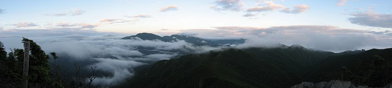
Photo: Σ64, Wikimedia Commons (CC BY-SA 3.0)

Mt. Kobushi (Kobushigatake) Hiking Guide: From Mokubidaira Along the Source of the Chikuma River, or From Nishizawa Valley
A guide to Mt. Kobushi (Kobushigatake, 2,475 m), where Yamanashi, Saitama and Nagano meet in Okuchichibu. The Mokubidaira route past the source of the Chikuma–Shinano River, the steep Tokuchan-shindō from Nishizawa Valley, the Jūmonji-tōge loop, parking, buses and the Kobushi Hut.
This guide is based on Kawakami Village, Yamanashi City, Yamanashi and Nagano Prefectures and the Kobushi Hut, checked October 24, 2026.
Introduction
Mt. Kobushi (甲武信ヶ岳, Kobushigatake; locals in Kawakami say Kobushidake) is a 2,475 m peak where Yamanashi, Saitama and Nagano Prefectures meet. Its name joins the first characters of the old provinces of Kōshū, Bushū and Shinshū, and it is one of Japan's 100 Famous Mountains in the Okuchichibu range.
It is also the watershed for three great rivers: the Fuefuki (Yamanashi City), the Arakawa (Chichibu) and the Chikuma, which becomes the Shinano, Japan's longest river (Kawakami Village). Walking up past the marker for the source of the Chikuma–Shinano gives this mountain a quiet sense of occasion you won't find elsewhere. Kawakami Village says that from the summit you can see the Yatsugatake range to the west, Mt. Fuji to the south and Mt. Ogura and Mt. Asama to the northwest.
The two main day routes are from Mokubidaira on the Nagano side, following the Chikuma River to its source, and from Nishizawa Valley on the Yamanashi side, up the Tokuchan-shindō trail. Both are long, serious days. The first has the story of following a river to its source; the second has the mossy, deep-forest feel typical of Okuchichibu.
Overview
| Item | Details |
|---|---|
| Location | Yamanashi City (Yamanashi), Chichibu (Saitama), Kawakami Village (Nagano) |
| Elevation | 2,475 m |
| Range | Okuchichibu |
| Category | 100 Famous Mountains, Yamanashi 100 Famous Mountains |
| Level | Intermediate; every route is long |
| Main trailheads | Mokubidaira (Nagano side), Nishizawa Valley entrance (Yamanashi side) |
| Hut | Kobushi Hut (staffed), just southeast of the summit |
Routes
1. Mokubidaira route (the classic)
Kawakami Village's times:
Mokubidaira parking → 1 h 40 min → Namedaru falls → 1 h 20 min → Chikuma–Shinano River source marker → 1 h → summit
That is about 4 hours up. You follow the Chikuma River upstream as it shrinks to a trickle, reach the source marker, and then climb steeply to the ridge and the summit. The climb after the source marker is a clear change from the gentle streamside walk, and it comes when you are starting to tire. Most people return the same way.
2. Jūmonji-tōge loop (from Mokubidaira)
Kawakami Village's times for the Jūmonji-tōge side:
Mokubidaira parking → 2 h → Jūmonji-tōge → 40 min → Ōyama → 2 h 40 min → Sanpōyama → 40 min → summit
Nagano Prefecture's 2026 mountain grading lists the loop Mokubidaira → Mt. Kobushi → Jūmonji-tōge → Mokubidaira as fitness level 4, technical grade B, 8.9 h of walking, 15.4 km, 1.37 km of total ascent. It takes much longer than the out-and-back, so choose it only if you have time and energy to spare.
3. Nishizawa Valley route (Tokuchan-shindō)
Nishizawa Valley entrance → Tokuchan-shindō (Towatari ridge) or Chikamaru-shindō → Mt. Tokusa → summit
Yamanashi City and Yamanashi Prefecture grade the route from the Nishizawa Valley entrance via Tokuchan-shindō as fitness level 4, technical grade B. Yamanashi Prefecture's route map marks steep sections: a steep slope with ropes, a stretch where the south side has crumbled away and the sandy path is unclear, a deeply eroded trench, and continuous steep grades where you should take care not to fall. The climb is long and relentless, which also makes it hard on the knees on the way down.


Highlights
The Chikuma–Shinano River source marker
The heart of the Mokubidaira route. A small stream narrows bit by bit until you reach the marker saying this is the source of Japan's longest river. It is a modest spot, but the stillness and the sense of "the start of a long journey" are something special.
The summit
The point where Yamanashi, Saitama and Nagano meet, with a fine summit sign. The ridges of Okuchichibu run off in every direction. Yamanashi City says you can see the Japan Alps, Mt. Fuji and many other Hyakumeizan from the top, though from the towns below the mountain is hidden behind Mt. Tokusa to the south.
Rhododendrons
Yamanashi Prefecture notes the large colonies of rhododendrons along the trails.



Access
Mokubidaira (Kawakami Village, Nagano)
- Go NAGANO (Nagano's official tourism site): about 80 minutes from Sudama IC or 70 minutes from Yachiho-kōgen IC; parking for 60 regular cars
- Toilet at Mokubidaira parking: Kawakami Village says it is usable until early November 2026, then closed for winter
- Public transport is limited; in practice a car is close to essential
Nishizawa Valley entrance (Yamanashi City, Yamanashi)
- Yamanashi City: about 60 minutes by bus from JR Yamanashi-shi Station to the "Nishizawa Keikoku Iriguchi" stop. The city-run Nishizawa Keikoku Line runs daily except January 1 and 2. Check the city's latest timetable for times.
- About 90 minutes by car from Katsunuma IC on the Chūō Expressway (Yamanashi City)
- Parking: city parking (60 cars) and the parking north of the roadside station (200 cars). The Yamanashi City Tourism Association says parking is charged only in the autumn leaf season.
Kobushi Hut
| Item | Details (Kobushi Hut official site) |
|---|---|
| Location | Just below the summit, in Chichibu-Tama-Kai National Park |
| Season | Late April to late November |
| With 2 meals | ¥10,000 (¥11,000 on specified dates) |
| With 1 meal | ¥8,500 (¥9,500) |
| Room only | ¥7,000 (¥8,000) |
| Tent | ¥1,500 |
| Latest news | The hut's blog or Instagram |
Clothing and gear
At 2,475 m, the summit area is cold even in summer, and the shaded Okuchichibu forest gets muddy after rain.
- Quick-dry long-sleeve base layer
- A fleece or light down jacket (essential)
- Rain gear that doubles as a windbreaker (essential)
- Mid-cut hiking boots, and gaiters for mud and streamside sections
- Gloves and a hat for the wind on the ridge
- Plenty of drinks and food, a map app, a power bank and a headlamp
Cautions
- It is long for a day hike. Plan an early start so you are not descending close to sunset.
- Afternoon thunderstorms in summer. Keep your time on the ridge short.
- Hard on the legs going down. Every route has a large height difference; use poles and take your time.
- Late season. The hut closes in late November and the Mokubidaira toilet closes in early November.
Who is it for?
- Hyakumeizan collectors who want to walk in Okuchichibu
- Hikers drawn to the story of tracing a river to its source
- Those who love rhododendrons and the quiet, deep forest of Okuchichibu
- Those ready for a serious day, or a night at the hut
If you want an easy Hyakumeizan with a short climb, you will enjoy this one more after gaining experience on others first.
Summary
Mt. Kobushi has a character nothing else can replace: the source of the Chikuma River, a summit where three prefectures meet, and the deep forest of Okuchichibu. The routes are long and not easy, but tracing the river from Mokubidaira to the top is one of the Hyakumeizan where you are most likely to feel "I'm glad I walked this".
References
- Hiking | Kawakami Village
- Public toilets at Mokubidaira parking | Kawakami Village
- Mokubidaira (Mt. Kobushi trailhead) | Go NAGANO
- Shinshu mountain grading list 2026 (PDF) | Nagano Prefecture
- Mt. Kobushi from the Nishizawa Valley entrance | Yamanashi City
- Mt. Kobushi from the Nishizawa Valley entrance | Yamanashi City Tourism Association
- City bus operating days and routes | Yamanashi City
- Yamanashi 100 Famous Mountains No. 81 Mt. Kobushi route map (PDF) | Yamanashi Prefecture
- Kobushi Hut (official site)