
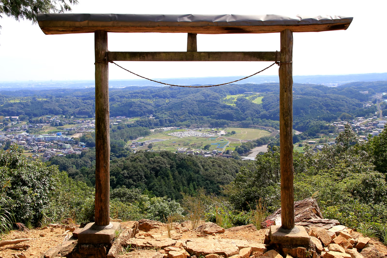
Photo: 京浜にけ, Wikimedia Commons (CC BY-SA 3.0) / Kinchakuda seen through the torii of Kotohira Shrine on Mt. Hiwada

Mt. Hiwada Hiking Guide: Otoko-zaka vs Onna-zaka, Koma Station, Parking and Toilets, and the Ridge Walk to Monomiyama and Gojō Falls
A guide to Mt. Hiwada (305 m) in Hidaka, Saitama: about 25 minutes on foot from Seibu Koma Station, the rocky Otoko-zaka (about 15 min) and gentle Onna-zaka (about 20 min), the view of Kinchakuda from the second torii, a 9.4 km ridge walk via Monomiyama and Gojō Falls, parking, toilets, early sunsets and bear sightings.
This guide is based on Hidaka City, Seibu Railway, the Gojō Falls foundation, Saitama Prefectural Police and the National Astronomical Observatory of Japan, checked October 24, 2026.
Mt. Hiwada (日和田山, Hiwada-san) is a 305 m hill loved as the symbol of Hidaka City in Saitama Prefecture. You can walk to the trailhead from Koma Station on the Seibu Ikebukuro Line, and from the second torii (Kotohira Shrine) halfway up you look down on Kinchakuda, the land enclosed by a big bend of the Koma River, and the town of Hidaka. Hidaka City says you can even see Tokyo Skytree on a clear day.
The key points for planning:
- Koma Station → Hiwada trailhead: about 25 minutes on foot. At the first torii the path splits into the rocky Otoko-zaka ("men's slope", about 15 minutes to the second torii) and the gentle Onna-zaka ("women's slope", about 20 minutes).
- Hidaka City says Otoko-zaka has "steep places where you have to use your hands", and recommends Onna-zaka especially for the descent.
- Continuing via Monomiyama (375.3 m) and Gojō Falls to Musashi-Yokote Station is 9.4 km with a standard walking time of 3 h 25 min on Seibu Railway's hiking map.
- Gojō Falls is a paid facility on private land: open 9:00–14:30, closed every Monday, Tuesday and Wednesday and over New Year (open on public holidays). Entry is ¥200 for adults.
- The 2026 Kinchakuda red spider lily festival ended on October 6. Sunsets come early from October, so start the ridge walk in the morning.
Three ways to walk it
| Option | Route | Distance / time | Good for |
|---|---|---|---|
| Mt. Hiwada only | Koma Stn → trailhead → Otoko-zaka or Onna-zaka → second torii → summit → down by Onna-zaka → Koma Stn | About 1.9 km each way; around 2 h of walking | First hikes, families, a morning-only outing |
| Mt. Hiwada + Kinchakuda | Add a stroll around Kinchakuda (flat land about 500 m across, enclosed by the river) | Add about 1 h | Those who also want flowers and riverside views |
| Ridge walk to Monomiyama and Gojō Falls | Koma Stn → Mt. Hiwada → Takasashiyama → Komataka → Monomiyama → Kitamuki Jizō → Gojō Falls → Musashi-Yokote Stn | 9.4 km, standard 3 h 25 min | Those wanting a solid half day |
The round-trip estimate takes Seibu's section times for the descent (Mt. Hiwada → Koma-Hongō → Koma Station, 45 min in total) and adds a margin for the climb. Kinchakuda's size (about 500 m across, about 22 ha) is from Hidaka City.
Otoko-zaka vs Onna-zaka
The path splits at the first torii and both branches rejoin at the second torii (Kotohira Shrine). Based on Hidaka City:
| Otoko-zaka | Onna-zaka | |
|---|---|---|
| Time to second torii | About 15 min | About 20 min |
| Terrain | Rugged rock; steep spots where you use your hands | Gently sloping path; handrails in places |
| Hidaka City's advice | "Choose your route at your own judgement" | For beginners and those unsure of their fitness; recommended especially for the descent |
| Best use | Climbing up on dry days only | Up and down; after rain, with children, when crowded |
Otoko-zaka is shorter but you keep putting your hands on rock. On wet days, or when people are queued ahead and behind, there is no need to force it: the view from the second torii is the same either way. The Onna-zaka handrails appear in the list of works under Hidaka City's "holy land of school excursions" project.
Rock climbing on the Otoko-iwa and Onna-iwa crags near Otoko-zaka is prohibited. Hidaka City cites fatal accidents and says "never climb them"; this also appears in Saitama Prefectural Police's mountain information.
From Koma Station to the second torii and the summit
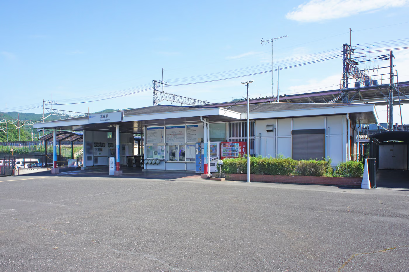

From Koma Station, follow signs for Kinchakuda and Mt. Hiwada through the residential area, cross the national road and enter the Koma-Hongō village. Hidaka City gives about 25 minutes on foot from the station to the trailhead.
A short climb through the trees brings you to the first torii and the Otoko-zaka / Onna-zaka junction. Climb either to the second torii and the view opens up over Kinchakuda and Hidaka. Hidaka City's guide map singles out the view near the second torii as "especially recommended", more than the summit. On a clear day you can see the Shinjuku skyscrapers and Tokyo Skytree.


A rocky path from the second torii leads to the summit, where a hōkyōintō stone pagoda stands and you can look out over Hidaka between the trees. Decide here whether to turn back or continue to Monomiyama. Go down by Onna-zaka, as Hidaka City recommends.
Extending the walk to Monomiyama and Gojō Falls
West from the summit, the ridge continues over Takasashiyama and Komataka to Monomiyama. Seibu Railway's hiking course "Road to the waterfall and the peaceful Koma mountain village" describes it in the direction from Musashi-Yokote Station to Koma Station. Distances and standard times from the map:
| Section (Seibu map direction) | Distance | Standard time | Notes |
|---|---|---|---|
| Musashi-Yokote Stn → Gojō Falls | 2.1 km | 30 min | Paved road, then a road closed to vehicles |
| Gojō Falls → Tsuchiyama | 1.2 km | 30 min | Climb through cedar woods |
| Tsuchiyama → Kitamuki Jizō | 0.8 km | 20 min | Up onto the ridge |
| Kitamuki Jizō → Monomiyama | 1.6 km | 40 min | Easy, flat path through cedar and cypress |
| Monomiyama → Komataka | 0.5 km | 15 min | Down to the village |
| Komataka → Takasashiyama | 0.6 km | 10 min | Toilet and shelter at Komataka |
| Takasashiyama → Mt. Hiwada | 0.7 km | 15 min | Take the trail to the right, not toward the (closed) relay station. Long, slippery descent |
| Mt. Hiwada → Koma-Hongō | 1.0 km | 30 min | Down past Kotohira Shrine |
| Koma-Hongō → Koma Stn | 0.9 km | 15 min | Through the village to the station |
| Total | 9.4 km | 3 h 25 min | 200–300 m of height difference with ups and downs (beginner level) |
Source: Seibu Railway hiking map (PDF)
Starting from Koma Station, read the table from the bottom up. The distance is the same, but the climbs and descents swap: up Mt. Hiwada, the climb back up from Komataka to Monomiyama, and a long descent from Gojō Falls to Musashi-Yokote Station. Allow more than the standard times.


Three things to know for the ridge walk:
- Komataka is one of the few places with a rest stop and toilet. It is a quiet mountain village, and Seibu says you may see Mt. Fuji beyond the hills in good conditions.
- Kitamuki Jizō is a junction. One way goes to Gojō Falls and Musashi-Yokote Station, the other to Higashi-Agano Station. If Gojō Falls is closed or you won't make its hours, you can descend to Higashi-Agano instead.
- Check Gojō Falls' rules on its official site. The Gojō Falls foundation lists opening hours of 9:00–14:30, closure every Monday, Tuesday and Wednesday and over New Year, and closure in bad weather such as rain, snow or typhoons; it is open on public holidays. Entry is ¥200 for adults (high-school age and up) and ¥100 for children (elementary school age and up). There is no toilet at the falls. Seibu's page still has the older "closed Mondays and Tuesdays", so go by the falls' own site.
Walking from Koma Station, you reach Gojō Falls after Monomiyama nearly 3 hours into the walk even by Seibu's standard times reversed, and longer with breaks. To make the 14:30 closing, aim to leave Koma Station by about 10:00 at the latest.
Mt. Hiwada from mid-October into winter


Kinchakuda after the spider lilies
The 2026 Kinchakuda red spider lily festival ran from September 21 to October 6, with paid entry ending on September 30. The Kinchakuda management office's bloom report was last updated on October 7 to say the blooming "has ended".
According to Hidaka City, once the flowers finish, thin leaves start growing around October, turning the colony green through the winter. The leaves wither around February, and the flowers return at the autumn equinox in September. The red carpet has to wait until next year, but the office says cosmos can be seen from around early October. The colours of Kinchakuda seen from the second torii are special to this season.
Early sunsets: plan back from your finish time
Sunset times in Saitama City from the National Astronomical Observatory of Japan (Hidaka is only 1–2 minutes later):
| Date (2026) | Sunset (Saitama) |
|---|---|
| October 16 | 17:05 |
| November 1 | 16:46 |
| November 15 | 16:35 |
| December 1 | 16:28 |
Even on a low hill, it gets dark in the woods before sunset. Start the ridge walk in the morning, and even for Mt. Hiwada alone, plan to begin your descent in the 14:00 hour.
Fallen leaves, frost and clear winter views
From November, leaves pile up on the ridges with their mixed woods and hide stones and roots. Winter mornings can be slippery with frost. Take extra care on the Otoko-zaka rocks and on the descent from Takasashiyama to Mt. Hiwada, which Seibu's map marks as slippery.
On the other hand, the clear winter air gives long views. Because the hill is low, the morning chill lifts quickly, and it is a quiet time to walk.
Access, parking and toilets
By train
Hidaka City gives about 50 minutes from Ikebukuro to Hannō and about 10 minutes from Hannō to Koma. From Koma Station it is about 25 minutes on foot to the trailhead. Musashi-Yokote Station, the end of the ridge walk, is on the Seibu Chichibu Line, so check return times on Seibu's timetable in advance.
From Komagawa Station on the JR Hachikō and Kawagoe lines, a Kokusai Kogyo bus takes about 10 minutes to the Kinchakuda stop, then it is about 10 minutes on foot to the trailhead (about 55 minutes on foot from Komagawa Station).
By car and parking
| Parking | Fee / hours | Notes |
|---|---|---|
| Kinchakuda parking (listed by Hidaka City) | Regular car ¥500, motorcycle ¥100; 7:00–17:00 | Not available December 29 – January 3 |
| Private lots near the trailhead | As posted on site | Few spaces; fill quickly on holidays |
| Gojō Falls free parking | 10 cars (no large buses) | For falls visitors |
Hidaka City gives directions from Sayama-Hidaka IC and Ken-Ō Tsurugashima IC on the Ken-Ō Expressway and Tsurugashima IC on the Kan-Etsu, and says Kinchakuda parking can be used. If you finish the ridge walk at Musashi-Yokote, take the train back to Koma to collect your car.
Toilets
| Place | Toilet |
|---|---|
| Koma Station | Yes |
| Kinchakuda | Yes (including a log-cabin toilet near the Doremifa Bridge) |
| Mt. Hiwada trail and summit | No |
| Komataka | Yes (public toilet and shelter) |
| Gojō Falls | No (the official site suggests bringing a portable toilet) |
| Musashi-Yokote Station | Yes |
Accidents on a low hill, and wildlife
Falls are common: wear stiff-soled shoes
Saitama Prefectural Police say of Mt. Hiwada that "it is a popular low mountain, but mountain accidents happen repeatedly", most of them falls and illness such as heatstroke. Sneakers have soft soles that slip and give poor grip, so hiking boots with stiff soles help, and high-cut boots also help prevent sprained ankles.
Bear sightings have been reported
Hidaka City's "Beware of wild animals" page (updated June 11, 2026) lists a sighting of a bear-like animal in Koma-Hongō (near Monomiyama) on June 7, 2026 (no bear signs found). On November 15, 2025, signs thought to be from a bear were found on a persimmon tree about 100 m southeast of Musashi-Yokote Station. The city asks hikers to carry bells, a radio or something else that makes noise, and to take care at dawn and dusk.
Check Hidaka City's latest sightings before you go and bring a bear bell. For the longer ridge walk, consider bear spray too. Hunting season also begins on November 15.
Clothing and gear
Mt. Hiwada is low, but from mid-October mornings and evenings are cold, and sweat chills you during breaks at the second torii or the summit. Dress in layers and bring:
- Shoes: light hiking boots or trekking shoes with stiff soles (as the police recommend)
- Outer layers: rain gear that doubles as a windbreaker, and a thin fleece
- Hands: grippy gloves for the Otoko-zaka rocks and leafy slopes
- Water and snacks: there are almost no shops on the mountain, so buy at the station or in the village (about 1 L for the ridge walk)
- A headlamp in case the ridge walk runs late
- Coins for the Gojō Falls entry and parking
- A portable toilet for the ridge walk, since Gojō Falls has none
- A map app and a power bank
FAQ
Q. Can beginners and children climb it?
A. Hidaka City describes Onna-zaka as suited to "beginners and those not confident in their fitness", and publishes an "excursion guide map" (with furigana) centred on Kinchakuda and Mt. Hiwada. For a first visit, going up and down by Onna-zaka is the safest choice.
Q. Can I go down Otoko-zaka?
A. Hidaka City "recommends Onna-zaka especially for the descent". Use Otoko-zaka for climbing only.
Q. Is there a view from the top of Monomiyama?
A. The top of Monomiyama is wooded; it is more a place to rest on a bench than a viewpoint. For views, the second torii on Mt. Hiwada is best.
Q. What if Mt. Hiwada alone isn't enough?
A. Besides the ridge walk to Monomiyama and Gojō Falls, the same Okumusashi area has higher hills such as Mt. Izu-ga-take (851 m) and Mt. Bōnoore (969 m).
References
- Mt. Hiwada | Hidaka City
- Kinchakuda, home to five million red spider lilies | Hidaka City
- Kinchakuda red spider lily festival 2026 | Hidaka City
- Hidaka excursion guide map | Hidaka City
- Beware of wild animals | Hidaka City
- Bloom report | Kinchakuda official site
- Autumn at Kinchakuda | Kinchakuda official site
- Road to the waterfall and the peaceful Koma mountain village | Seibu Railway hiking courses
- Fees and opening hours | Gojō Falls
- Mountain information | Saitama Prefectural Police
- Sunrise and sunset, Saitama, November 2026 | NAOJ Ephemeris Computation Office