

Photo: Yama-Nikki (Taken August 5, 2026 — Bamboo-grass ridge on the Mt. Azumaya–Nekodake loop)
Mt. Azumaya & Mt. Nekodake Loop Hike Report (Aug 2026): Sugadaira Ranch via Naka-Azumaya
First-hand August 2026 hiking report of the Mt. Azumaya (2,354 m, Hyakumeizan) and Mt. Nekodake (2,207 m) loop from Sugadaira Ranch on the Nagano–Gunma border—covering GPS split times, bamboo-grass ridges, sea-of-clouds views, parking fees (¥200), and post-hike soft-serve ice cream.
On Wednesday, August 5, 2026, I hiked the clockwise loop over Mt. Azumaya (四阿山, Azumayasan, 2,354 m)—one of Japan's 100 Famous Mountains (Nihon Hyakumeizan)—and neighboring Mt. Nekodake (根子岳, 2,207 m) starting and ending at the Sugadaira Ranch Trailhead (菅平牧場登山口) in Ueda City, Nagano Prefecture.
Because I arrived at the trailhead parking lot around 5:00 AM and set off at 5:16 AM, I was able to climb in the cool morning air before the midsummer sun heated up the open ridges, watch a dramatic sea of clouds roll across the valleys from Ko-Azumaya and the summit, and finish back at the ranch by 8:38 AM—just in time for a fresh ranch soft-serve ice cream when the stand opened at 9:00 AM.
Hike Summary & Actual GPS Split Times (August 5, 2026)
| Item | Recorded Details |
|---|---|
| Date | Wednesday, August 5, 2026 (Day Hike) |
| Route | Sugadaira Ranch Trailhead (Clockwise Loop) → Stream Crossing → Ko-Azumaya → Naka-Azumaya → Mt. Azumaya (2,354 m) → Osukima Saddle (大スキマ) → Mt. Nekodake (2,207 m) → Sugadaira Ranch |
| Total Distance | 12.5 km (Yamareco GPS log) |
| Cumulative Elevation Gain / Loss | +1,092 m / -1,092 m |
| Total Time | 3 hr 22 min (Start 5:16 → Finish 8:38; fast solo pace ~0.5–0.6× standard time; standard map time is ~6 hr 30 min) |
| Nagano Trail Grade | Physical Fitness 4, Technical Difficulty B (Nagano Trail Grading) |
| Observed Weather (JMA Sugadaira AMeDAS, 1,253 m) | 5:00 AM 19.1°C → 6:00 AM 20.8°C → 7:00 AM 23.8°C → 8:00 AM 25.9°C → 9:00 AM 27.1°C, light breeze 1.2–2.2 m/s, 0.0 mm rain (JMA Sugadaira Hourly Data for Aug 5, 2026) |
Waypoint Split Table
| Waypoint | Time | Elapsed | Notes |
|---|---|---|---|
| Sugadaira Ranch Parking (菅平牧場駐車場, ~1,590 m) | 05:16 | 0:00 | Departed along the pasture edge toward the Mt. Azumaya trailhead |
| Ko-Azumaya (小四阿, 1,917 m) | 06:00 | 0:44 | First open viewpoint; sea of clouds visible below |
| Naka-Azumaya (中四阿, 2,106 m) | 06:26 | 1:10 | Sweeping open bamboo-grass ridge leading toward the main peak |
| nekodake / Azumaya Junction | 06:51 | 1:35 | Merged with the trail coming up from Mt. Nekodake |
| Torii Pass Junction (鳥居峠分岐) | 06:57 | 1:41 | Below the final wooden staircase to the summit |
| Mt. Azumaya Summit (四阿山, 2,354 m) | 07:02–07:06 | 1:46 | Visited both Yamaga Shrine Okumiya shrines (Shinshu & Kozuke crests) |
| Nekodake Junction (Return) | 07:14 | 1:58 | Turned north toward the Osukima saddle and Mt. Nekodake |
| Mt. Nekodake Summit (根子岳, 2,207 m) | 07:58 | 2:42 | Climbed out of the deep Osukima saddle through chest-high bamboo grass |
| East Gazebo (東あずまや) | 08:23 | 3:07 | Gentle pasture-side descent with views of cattle grazing |
| Sugadaira Ranch Parking (Finish) | 08:38 | 3:22 | Returned to parking lot; Milk House opened at 9:00 AM |
Trail Report: Step by Step Along the Loop
1. Sugadaira Ranch Trailhead to Ko-Azumaya & Naka-Azumaya (05:16–06:26)
I chose to walk the loop clockwise (climbing Mt. Azumaya first via Naka-Azumaya, then crossing to Mt. Nekodake and descending the broad ranch trail). Walking clockwise lets you tackle the longer forest and ridge climb to 2,354 m while your legs are freshest, and saves the gentle, open pasture descent from Mt. Nekodake for the end.
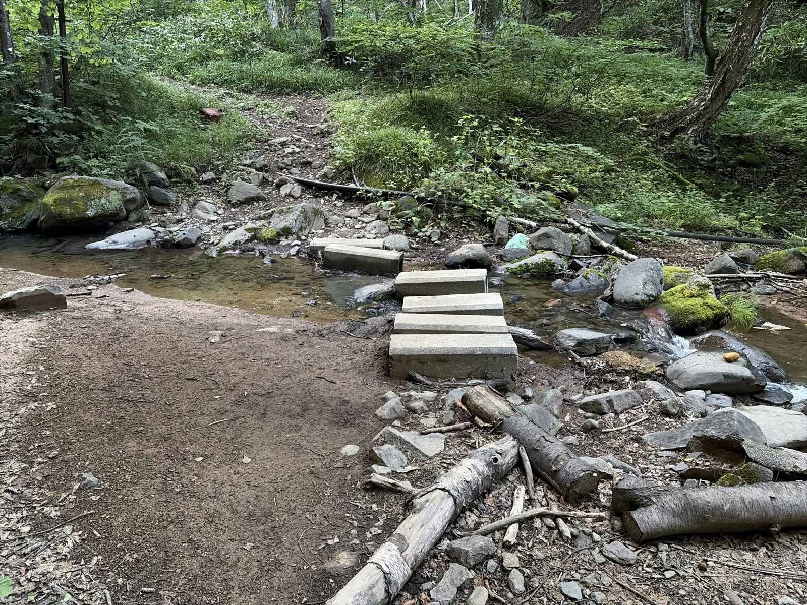
After passing the wooden gate above the parking lot, the trail enters a cool birch and deciduous forest and crosses a small stream on stepping stones. From there, a steady climb over tree roots brings you out onto the first rocky prominence at Ko-Azumaya (小四阿, 1,917 m) at 6:00 AM.


Above Ko-Azumaya, the trees give way to open kumazasa (bamboo grass) slopes. Even in early August, a cool breeze drifted across the ridge, and the morning sunlight illuminated the green carpet leading up to Naka-Azumaya (中四阿, 2,106 m).


2. Wooden Stairs to the Summit of Mt. Azumaya (2,354 m) (06:26–07:06)
Past Naka-Azumaya, the trail merges with the path coming from Mt. Nekodake (6:51 AM) and then the Palcall Tsumagoi / Torii Pass route (6:57 AM). A long flight of well-maintained wooden stairs leads up the final pitch to the narrow ridge summit of Mt. Azumaya (2,354 m).


Because Mt. Azumaya straddles the historic border of Shinano Province (Nagano) and Kozuke Province (Gunma), the summit area houses two okumiya (inner shrines) of Yamaga Shrine (山家神社)—one facing the Shinshu side and one facing the Kozuke side (Tsumagoi Village Mt. Azumaya Guide PDF).
3. Crossing the "Osukima" Saddle to Mt. Nekodake (2,207 m) (07:06–07:58)
From the junction below Mt. Azumaya, I turned toward Mt. Nekodake (根子岳, 2,207 m)—famous as one of Japan's 100 Flower Mountains (Hana no Hyakumeizan).

- Watch Out for the "Osukima" (大スキマ) Saddle & Bamboo Grass: Although Mt. Nekodake looks close from Mt. Azumaya, you first drop sharply down eroded rock and tree roots into a deep saddle called Osukima before climbing roughly 170 meters back up to Mt. Nekodake. In mid-summer, the bamboo grass (kumazasa) in this saddle grows dense and brushes against your legs and arms; wearing long trekking pants (or tights with gaiters) and long sleeves is essential to prevent grass cuts, morning dew soak, and ticks.

4. Gentle Descent Along Sugadaira Ranch & Post-Hike Soft-Serve Ice Cream (07:58–08:38)
From the summit of Mt. Nekodake, a wide, open ridge trail descends gently along the fence line of Sugadaira Ranch (菅平牧場) past the East Gazebo (Higashi Azumaya), returning to the parking lot at 8:38 AM.
Right beside the parking lot stands Sugadaira Ranch Milk House (牛乳屋 / 売店), which opens at 9:00 AM during the green season (late April to mid-October, closed Wednesdays outside peak summer; check Sugadaira Highland Official Guide and Ueda Tourism Association). Rewarding yourself with their rich ranch soft-serve ice cream (¥400) and fresh milk right after finishing the loop is one of the best traditions of hiking from Sugadaira!
Practical Logistics: Sugadaira Ranch Access, Parking Fee & Trailhead Notes (2026 Verified)
| Item | Official 2026 Details | Source |
|---|---|---|
| Road Access | Joshin-Etsu Expressway Ueda-Sugadaira IC → Route 144 & 406 (~35–40 min) or Suzaka-Nagano-Higashi IC (~35 min) | Sugadaira Highland Official Site |
| Sugadaira Ranch Road Maintenance Fee (Parking) | ¥200 per passenger car (collected at the ranch toll booth during operating hours; if you enter before the booth opens in the early morning, pay upon exit or follow posted instructions) | Sugadaira Ranch Fee Schedule |
| Restrooms & Water | Flush restrooms with toilet paper and a boot-washing station are available at the Sugadaira Ranch parking lot. There are NO water sources, restrooms, or mountain huts anywhere along the loop. | Joshin'etsu Kogen National Park Official Guide |
| Alternative Trailhead Note (Torii Pass Forestry Road) | If you are considering the Gunma side, check the Tsumagoi Tourism Association Torii Pass Rindo Notice before driving, as forestry roads can have seasonal or rain-related closures. | Tsumagoi Tourism Association |