

Photo: STA3816, Wikimedia Commons (CC BY-SA 3.0)
5 Day-Hikeable 100 Famous Mountains in Kyushu: Difficulty, Routes & Access Guide
Five of Kyushu's six 100 Famous Mountains (Nihon Hyakumeizan)—Mt. Kuju, Mt. Aso, Mt. Kirishima (Karakuni-dake), Mt. Kaimondake, and Mt. Sobo—can be climbed on a day hike. Compare round-trip times, elevation gain, volcanic alert checks, and trailhead access from Fukuoka, Kumamoto, and Kagoshima.
Information checked October 24, 2026 against official notices from the Ministry of the Environment (Aso-Kuju National Park and Yakushima World Heritage Conservation Center), the Japan Meteorological Agency (Volcanic Activity Information), Kokonoe Town, Aso City, the Ebino Eco-Museum Center, and Ibusuki City.
Six of Japan's 100 Famous Mountains (Nihon Hyakumeizan) stand in Kyushu: Mt. Kuju, Mt. Aso, Mt. Sobo, Mt. Kirishima (Karakuni-dake), Mt. Kaimondake, and Mt. Miyanoura-dake (on Yakushima Island).
Except for Miyanoura-dake—which requires traveling to Yakushima Island—all five mainland Kyushu Hyakumeizan can be climbed on a single-day hike. High-elevation pass roads allow hikers to start above 1,000 meters on several peaks, keeping round-trip walking times between 3 and 5.5 hours while delivering expansive volcanic calderas, crater lakes, and coastal panoramas.
Comparison of Kyushu's 5 Day-Hikeable 100 Famous Mountains
| Mountain | Prefecture | Highest Point | Main Day-Hike Trailhead | Round-Trip Time | Elevation Gain | Level |
|---|---|---|---|---|---|---|
| Mt. Kuju (Kuju Range) | Oita | 1,791 m (Nakadake) / 1,787 m (Kuju-san) | Makinoto Pass (1,330 m) | ~4.5–5 hr | ~460 m | Beginner |
| Mt. Aso | Kumamoto | 1,592 m (Takadake) | Sensuikyo (~900 m) / Sunasenri | ~4–4.5 hr | ~690 m | Beginner–Intermediate |
| Mt. Kirishima (Karakuni-dake) | Miyazaki / Kagoshima | 1,700 m | Ebino Plateau (1,200 m) | ~3–3.5 hr | ~500 m | Beginner |
| Mt. Kaimondake | Kagoshima | 924 m | Kaimon Sanroku Fureai Park (~140 m) | ~4.5–5 hr | ~780 m | Beginner–Intermediate |
| Mt. Sobo | Oita / Miyazaki | 1,756 m | Kitadani Trailhead (~1,100 m) | ~4.5–5.5 hr | ~650 m | Intermediate |
Note: Mt. Kuju, Mt. Aso, Mt. Kirishima, and Mt. Kaimondake are active volcanoes monitored by the Japan Meteorological Agency (JMA). Always check current Volcanic Alert Levels and local crater restrictions before departing.
1. Mt. Kuju (九重山 / 1,791 m, Oita) — The "Roof of Kyushu"
Why Hike Mt. Kuju
Mt. Kuju (九重山, Kuju-san) is the collective name for the volcanic mountain range in central Oita Prefecture. Its main peak is Kuju-san (久住山, 1,787 m), while nearby Nakadake (中岳, 1,791 m) is the highest point on mainland Kyushu. Because the Makinoto Pass Trailhead (牧ノ戸峠) sits at 1,330 meters on the Yamanami Highway, hikers gain the open alpine ridge quickly with modest elevation gain.
In late May to mid-June, the slopes turn bright pink with Miyama-kirishima (Kyushu azaleas); in mid-to-late October, autumn foliage colors the valleys; and in mid-to-late November, rime ice (muhyo) decorates the upper ridges.
Main Day-Hike Routes
- Makinoto Pass Route (牧ノ戸峠コース — Most Popular)
- Course: Makinoto Pass (1,330 m) → Kutsukake-yama (1,503 m) → Ogi-ga-hana Junction → Kuju-wakare → Kuju-san (1,787 m) → (optional: Nakadake 1,791 m, +30 min each way) → return the same way
- Round-Trip Time: ~4.5–5 hours
- Distance / Elevation Gain: ~9–10 km / ~460 m
- Highlights: The first 20–30 minutes follow a paved footpath to a viewpoint, followed by rocky ridge walking past Kutsukake-yama and a wide gentle plateau leading to Kuju-wakare (where a public toilet facility is located).
- Chojabaru Route (長者原コース)
- Course: Chojabaru Trailhead (~1,030 m) → Tadewara Marsh (Ramsar wetland boardwalk) → Amagaike → Bogatsuru Marsh → Kuju-san / Nakadake
- Round-Trip Time: ~6–7 hours
- Highlights: Passes through the flat basin of Bogatsuru and close to Hokkein Onsen Sanso (法華院温泉山荘), Kyushu's highest hot-spring mountain lodge.
Access & Parking
- By Car: ~1.5 hours from Fukuoka via the Oita Expressway Kokonoe IC (九重IC) and Prefectural Route 40 / Route 11 (Yamanami Highway) to Makinoto Pass. Free parking, toilets, and a shop are available at Makinoto Pass, though the lot often fills before 6:00 AM on weekends during the May–June azalea and October foliage peaks.
- Official Information:
2. Mt. Aso (阿蘇山 / 1,592 m, Kumamoto) — Dynamic Caldera & Crater Landscapes
Why Hike Mt. Aso
Surrounded by one of the world's largest caldera rims (gairinzan), the central cones of Mt. Aso (Aso Gogaku) reach their highest point at Takadake (高岳, 1,592 m) alongside the active Nakadake (中岳, 1,506 m). Barren lava ridges and black volcanic ash plains create an otherworldly volcanic landscape.
Mandatory Volcanic Alert Check
Nakadake's First Crater (第一火口) is an active crater that emits volcanic gases (including sulfur dioxide, $\text{SO}_2$).
- Volcanic Alert Level 1: Crater viewing area is generally open (subject to real-time volcanic gas restrictions), and trails to Nakadake and Takadake are open.
- Volcanic Alert Level 2 or Higher: Entry within roughly 1 km of the Nakadake crater is prohibited, and trail access changes depending on the restricted zone.
- Always check the Aso City Mt. Aso Trail & Crater Regulation Page and the JMA Aso-san Volcanic Activity Information (503) immediately before your hike.
Main Day-Hike Routes
- Sensuikyo Route (仙酔峡ルート)
- Course: Sensuikyo Parking (~900 m) → Sensuikyo Tail Ridge (Baka-one) → Takadake (1,592 m) → Nakadake (1,506 m) → return via Sensuikyo
- Round-Trip Time: ~4–4.5 hours
- Elevation Gain: ~690 m
- Cautions: The former Sensuikyo Ropeway is permanently closed and dismantled. The Baka-one ridge ascends ~600 m relentlessly over steep volcanic rock with painted yellow circle markers and zero shade—carry extra water and sun protection on warm days.
- Sunasenri Route (砂千里ヶ浜ルート)
- Course: Aso Sanjo Terminal → Sunasenri-ga-hama volcanic ash plain → South Ridge → Nakadake → Takadake → return the same way
- Round-Trip Time: ~4 hours
- Cautions: Only accessible when volcanic alert and gas conditions permit entry via the Aso Sanjo side.
Access & Parking
- By Car: ~2 hours from Fukuoka via the Kyushu Expressway Kumamoto IC and Route 57 to Sensuikyo (free parking, ~100 spaces, toilets) or the Aso Panorama Line to Aso Sanjo Terminal.
- By Public Transit: From JR Aso Station (阿蘇駅) on the Hohi Main Line, take the Sanko Bus to Aso Sanjo Terminal (阿蘇山上ターミナル) (~35 minutes).
3. Mt. Kirishima / Karakuni-dake (霧島山・韓国岳 / 1,700 m, Miyazaki & Kagoshima)
Why Hike Karakuni-dake
Mt. Kirishima (霧島山) is a volcanic cluster straddling the border of Miyazaki and Kagoshima prefectures. Its highest peak, Karakuni-dake (韓国岳, 1,700 m), is the easiest Hyakumeizan in Kyushu to climb on a day hike: starting from Ebino Plateau (えびの高原) at 1,200 meters, hikers reach the summit in roughly 1.5 to 2 hours.
From the summit rim, you look straight down into a dramatic crater 900 meters wide and 300 meters deep, with views across Onami Pond (大浪池), Shinmoedake (新燃岳), and Takachiho-no-mine (高千穂峰).
Main Day-Hike Routes
- Ebino Plateau Route (えびの高原コース — Shortest & Most Popular)
- Course: Ebino Plateau Trailhead (1,200 m) → Io-yama Flank → 5th Station Viewpoint → Karakuni-dake Summit (1,700 m) → return the same way
- Round-Trip Time: ~3–3.5 hours
- Distance / Elevation Gain: ~6 km / ~500 m
- Highlights: Well-maintained stone paths and wooden stairs climb steadily to the crater rim with unobstructed views above the treeline from the 5th station upward.
- Onami Pond Route (大浪池コース)
- Course: Onami-ike Trailhead → Onami Pond Crater Rim → Karakuni-dake Summit → return via Onami Pond or loop back to Ebino Plateau
- Round-Trip Time: ~4–4.5 hours
- Highlights: Combines a walk along the emerald-green crater lake of Onami Pond with a steeper wooden-stair climb up the southern flank of Karakuni-dake.
Volcanic Precautions & Access
- Volcanic Alerts: Io-yama (adjacent to Ebino Plateau) and Shinmoedake are active volcanic centers in the Kirishima range. Check road and trail restrictions with the Ebino Eco-Museum Center and the JMA Kirishima-yama Volcanic Activity Page (505) before setting out.
- By Car: ~25–30 minutes from the Kyushu Expressway Ebino IC or Kobayashi IC (~2.5–3 hours from Fukuoka). Paid parking, restrooms, and the visitor center are located at Ebino Plateau.
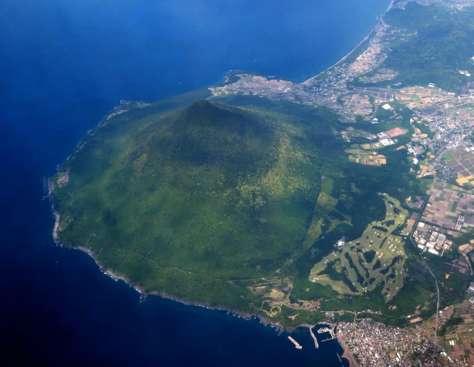
4. Mt. Kaimondake (開聞岳 / 924 m, Kagoshima) — The Spiral Trail up "Satsuma Fuji"
Why Hike Mt. Kaimondake
Rising 924 meters directly from the coast at the southern tip of the Satsuma Peninsula, Mt. Kaimondake (開聞岳) is one of the lowest peaks in the 100 Famous Mountains, yet hikers climb nearly its entire height from the 2nd station (~140 m). Because no surrounding ridges block the view, the summit offers a 360-degree panorama encompassing the East China Sea, Nagasaki-bana Cape, Lake Ikeda, Sakurajima, Kirishima, and—on clear days—Yakushima and the Tokara Islands.
Thanks to its southern coastal location and sub-1,000 m elevation, snow is rare, making Kaimondake an ideal late-autumn, winter, and early-spring climb (midsummer is very hot and humid inside the coastal forest).
Spiral Climbing Route (らせん状登山道)
- Course: Kaimon Sanroku Fureai Park (2nd Station Trailhead, ~140 m) → 5th Station Viewpoint → 7th Station (Sennin Cave) → 9th Station → Kaimondake Summit (924 m) → return the same way
- Round-Trip Time: ~4.5–5 hours (~2.5–3 hours up, ~2 hours down)
- Distance / Elevation Gain: ~8 km / ~780 m
- Trail Features:
- 2nd to 5th Station: Shaded forest trail spiraling gently around the cone. The 5th station has a rest bench and an open view over the peninsula.
- 5th to Summit: Volcanic boulders, wet tree roots, wooden stairs, ladders, and fixed ropes become frequent above the 7th station. Wear trekking shoes with solid grip and bring gloves for the rocky sections.
Access & Parking
- By Public Transit (Train-Accessible!): Walk ~15–20 minutes from JR Kaimon Station (開聞駅) on the JR Ibusuki-Makurazaki Line (~1 hour 20 minutes from Kagoshima-Chuo Station) to the 2nd Station trailhead at Kaimon Sanroku Fureai Park.
- By Car: ~1 hour from Kagoshima City (Taniyama IC) or ~3.5–4 hours from Fukuoka via the Kyushu Expressway and Ibusuki Skyline. Free parking and restrooms are available at Kaimon Sanroku Fureai Park (かいもん山麓ふれあい公園).
- Official Information:
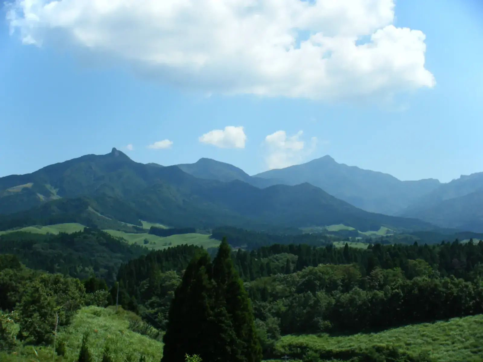
5. Mt. Sobo (祖母山 / 1,756 m, Oita & Miyazaki) — Rugged Peak in a UNESCO Biosphere Reserve
Why Hike Mt. Sobo
Standing on the border of Oita and Miyazaki prefectures, Mt. Sobo (祖母山, 1,756 m) is the highest peak in Miyazaki Prefecture and the centerpiece of the Sobo, Katamuki and Okue Biosphere Reserve (UNESCO Eco-Park). Unlike the volcanic grasslands of Kuju and Aso, Sobo is an ancient uplifted granitic and volcanic massif cloaked in primeval beech, hemlock (tsuga), and akebono-tsutsuji (pentaphyllum rhododendron, blooming in early May), with steep rocky crags near the top.
Main Day-Hike Routes
- Kitadani Trailhead Route (北谷登山口コース — Miyazaki / Takachiho Side, Shortest for Day Hikers)
- Course: Kitadani Trailhead (~1,100 m) → Wind Hole (Kaza-ana) → Kunimidake Pass (国観峠) → 9th Station Emergency Hut → Mt. Sobo Summit (1,756 m) → return via Sengendaira (千間平) ridge → Kitadani Trailhead
- Round-Trip Time: ~4.5–5.5 hours
- Distance / Elevation Gain: ~8 km / ~650 m
- Cautions: Between the 9th Station Hut and the summit, the trail climbs steep rock steps, roots, and short ladders. In addition, the final ~4 km approach road to Kitadani Trailhead includes narrow, unpaved sections with protruding stones—drive slowly and avoid low-clearance vehicles.
- Obira Trailhead Route (尾平登山口コース — Oita / Bungo-Ono Side)
- Course: Obira Trailhead (~580 m) → Miyabara Course → 9th Station Hut → Mt. Sobo Summit → return via Miyabara Course (avoid the steep Kurogane Ridge on descent)
- Round-Trip Time: ~6.5–7.5 hours
- Elevation Gain: ~1,180 m (for experienced hikers with an early morning start).
Access & Parking
- By Car: ~2.5–3 hours from Fukuoka via the Kyushu Expressway Kumamoto IC or Mifune IC, Route 265 / Route 325 through Takamori and Takachiho to Kitadani Trailhead (free parking, ~20–30 spaces, toilet at trailhead). No public buses serve the trailhead directly.
Why Miyanoura-dake (Yakushima, 1,936 m) Requires an Overnight Trip
Kyushu's sixth 100 Famous Mountain—and the highest peak in all of Kyushu—is Mt. Miyanoura-dake (宮之浦岳, 1,936 m) in the interior of Yakushima Island (屋久島).
- Even on the standard day-hike route from Yodogawa Trailhead (淀川登山口, 1,360 m), the round trip covers roughly 16 km and 8 to 9 hours of walking.
- Because travelers must reach Yakushima by flight, high-speed jetfoil, or ferry from Kagoshima and then drive ~1 hour up a narrow mountain road to Yodogawa Trailhead, a day trip from mainland Kyushu is not practical; plan at least a 1-night, 2-day (or 2-night, 3-day) itinerary on Yakushima.
- See the Ministry of the Environment — Yakushima World Heritage Conservation Center: Yodogawa Trailhead to Miyanoura-dake Route Guide for official course times and trail rules.
Recommended Multi-Peak Itineraries in Kyushu
Because pairs of Kyushu's Hyakumeizan sit close together, traveling hikers often combine them over a weekend:
- Northern Kyushu Golden Pair (1 Night, 2 Days from Fukuoka or Kumamoto)
- Day 1: Hike Mt. Kuju from Makinoto Pass (~4.5–5 hr), soak in Kurokawa Onsen or筋湯温泉 (Sujiyu Onsen).
- Day 2: Drive the Yamanami Highway to Mt. Aso (~1 hr drive) and climb Takadake & Nakadake (~4–4.5 hr).
- Southern Kyushu Volcanic Pair (1 Night, 2 Days from Kagoshima Airport)
- Day 1: Climb Mt. Kirishima (Karakuni-dake) from Ebino Plateau (~3–3.5 hr) and stay in Kirishima Onsen or Ibusuki Onsen.
- Day 2: Climb Mt. Kaimondake (~4.5–5 hr) and soak in Ibusuki's famous sand baths (sunamushi onsen).
Reference Links
- Kokonoe Town — Kuju Mountain Range Climbing Route Guide
- Ministry of the Environment — Aso-Kuju National Park / Chojabaru Visitor Center Information
- Aso City — Mt. Aso Trail Map & Crater Regulation Information
- Ebino Eco-Museum Center (Kirishima-Kinkowan National Park)
- Ibusuki City Official Tourism Site (Ibusuki Kanko Net) — Mt. Kaimondake
- Ministry of the Environment — Yakushima World Heritage Conservation Center: Yodogawa to Miyanoura-dake Route
- Japan Meteorological Agency — Kuju-san Volcanic Activity Information (502)
- Japan Meteorological Agency — Aso-san Volcanic Activity Information (503)
- Japan Meteorological Agency — Kirishima-yama Volcanic Activity Information (505)
- Japan Meteorological Agency — Kaimondake Volcanic Activity Information (509)